List of lakes of Washington
This is a list of natural lakes and reservoirs located fully or partially in the U.S. state of Washington. Natural lakes that have been altered with a dam, such as Lake Chelan, are included as lakes, not reservoirs. Swimming, fishing, and/or boating are permitted in some of these lakes, but not all.
-
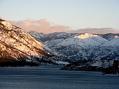 Lake Chelan
 -
 Lake Washington
 -
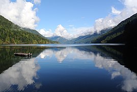 Lake Crescent
 -
 Palmer Lake
 -
 Lake Quinault


Map all coordinates using OpenStreetMap
Download coordinates as:
- KML
- GPX (all coordinates)
- GPX (primary coordinates)
- GPX (secondary coordinates)
Natural lakes
Currently included in this table are all natural and enhanced lakes with a surface area of more than 1,000 acres or a volume of more than 25,000 acre feet as well as smaller lakes (down to 100 acres) with a Wikipedia page.
| Name | County(s) | Elev. (ft) | Area (acres) | Volume (acre ft) | Depth (max)(ft) | Outflow | Basin | Coordinates | Notes | Reference |
|---|---|---|---|---|---|---|---|---|---|---|
| Lake Chelan | Chelan | 1,102 | 33,000 | 15,800,000 | 1,486 | Chelan River | Columbia / Chelan | 48°01′37″N 120°20′17″W / 48.027°N 120.338°W / 48.027; -120.338 (Lake Chelan) | [note 1] | [1][2][3][4][5] |
| Lake Washington | King | 17 | 22,000 | 2,400,000 | 214 | Lake Washington Ship Canal | Lake Washington | 47°37′19″N 122°15′22″W / 47.622°N 122.256°W / 47.622; -122.256 (Lake Washington) | [note 2] | [1][3][4][5] |
| Lake Ozette | Clallam | 33 | 7,400 | 960,000 | 331 | Ozette River | Ozette River | 48°05′42″N 124°38′13″W / 48.095°N 124.637°W / 48.095; -124.637 (Lake Ozette) | [note 3] | [1][3][6][5] |
| Moses Lake | Grant | 1,050 | 6,800 | 130,000 | 38 | Crab Creek | Columbia / Crab Creek | 47°07′26″N 119°20′20″W / 47.124°N 119.339°W / 47.124; -119.339 (Moses Lake) | [note 4] | [1][3][6][5] |
| Osoyoos Lake | Okanogan / B.C.‡ | 911 | 5,800 | 270,000 | 208 | Okanogan River | Columbia / Okanogan | 49°00′00″N 119°26′38″W / 49°N 119.444°W / 49; -119.444 (Osoyoos Lake) | [note 5] | [1][7][3][5] |
| Lake Crescent | Clallam | 584 | 5,100 | 1,500,000 | 624 | Lyre River | Lyre River | 48°03′36″N 123°49′41″W / 48.06°N 123.828°W / 48.06; -123.828 (Lake Crescent) | [note 6] | [8][3][5] |
| Lake Whatcom | Whatcom | 312 | 4,900 | 770,000 | 328 | Whatcom Creek | Bellingham Bay | 48°44′02″N 122°19′52″W / 48.734°N 122.331°W / 48.734; -122.331 (Lake Whatcom) | [note 7] | [1][3][6][4][5] |
| Lake Sammamish | King | 30 | 4,900 | 284,000 | 105 | Sammamish River | Lake Washington | 47°35′38″N 122°05′53″W / 47.594°N 122.098°W / 47.594; -122.098 (Lake Sammamish) | [1][6][4][5] | |
| Cle Elum Lake | Kittitas | 2,227 | 4,800 | 520,000 | 260 | Cle Elum River | Columbia / Yakima | 47°16′01″N 121°05′38″W / 47.267°N 121.094°W / 47.267; -121.094 (Cle Elum Lake) | [note 8] | [1][9][5] |
| Baker Lake | Whatcom | 705 | 4,800 | 285,000 | Baker River | Skagit River | 48°45′54″N 121°32′34″W / 48.765°N 121.542778°W / 48.765; -121.542778 (Baker Lake) | |||
| Kachess Lake | Kittitas | 2,258 | 4,500 | 550,000 | 410 | Kachess River | Columbia / Yakima | 47°19′01″N 121°14′17″W / 47.317°N 121.238°W / 47.317; -121.238 (Kachess Lake) | [note 9] | [1][3][5] |
| Lake Cushman | Mason | 739 | 4,010 | 115 | Skokomish River | 47°28′48″N 123°15′0″W | ||||
| Lake Quinault | Grays Harbor | 186 | 3,550 | 496,000 | 240 | Quinault River | Quinault River | 47°28′26″N 123°52′16″W / 47.474°N 123.871°W / 47.474; -123.871 (Lake Quinault) | [4][5] | |
| Omak Lake | Okanogan | 958 | 3,250 | 700,000 | 325 | None | Columbia Basin | 48°16′37″N 119°23′56″W / 48.277°N 119.399°W / 48.277; -119.399 (Omak Lake) | [note 10] | [1][3][6] |
| Keechelus Lake | Kittitas | 2,521 | 2,600 | 250,000 | 310 | Yakima River | Columbia / Yakima | 47°19′37″N 121°21′07″W / 47.327°N 121.352°W / 47.327; -121.352 (Keechelus Lake) | [note 11] | [1][10][5] |
| Spirit Lake | Skamania | 3,440 | 2,600 | 212,000 | 110 | North Fork Toutle River | Columbia / Cowlitz | 46°16′08″N 122°08′28″W / 46.269°N 122.141°W / 46.269; -122.141 (Spirit Lake) | [note 12] | [11][12] |
| Lake Wenatchee | Chelan | 1,872 | 2,500 | 360,000 | 244 | Wenatchee River | Columbia / Wenatchee | 47°49′23″N 120°46′41″W / 47.823°N 120.778°W / 47.823; -120.778 (Lake Wenatchee) | [1][13][6][5] | |
| Lake Tapps | Pierce | 546 | 2,430 | 47,000 [14] | 90 | White River | Puyallup River | 47°12′50″N 122°10′08″W / 47.214°N 122.169°W / 47.214; -122.169 (Lake Tapps) | [note 13] | [15][6][4][5][12] |
| Silver Lake | Cowlitz | 489 | 2,300 | 13,000 | 10 | Outlet Creek | Columbia / Cowlitz | 46°17′24″N 122°47′56″W / 46.29°N 122.799°W / 46.29; -122.799 (Silver Lake) | [note 14] | [1][3][6][5] |
| Vancouver Lake | Clark | 8 | 2,300 | 6,900 | 15 | Lake River | Columbia Basin | 45°40′26″N 122°43′05″W / 45.674°N 122.718°W / 45.674; -122.718 (Vancouver Lake) | [3][4][5][12] | |
| Rock Lake | Whitman | 1,728 | 2,200 | 380,000 | 350 | Rock Creek | Columbia / Snake | 47°10′55″N 117°40′48″W / 47.182°N 117.68°W / 47.182; -117.68 (Rock Lake) | [note 15] | [1][16][3][6][4][5] |
| Palmer Lake | Okanogan | 1,150 | 2,100 | 110,000 | 79 | Palmer Creek | Columbia / Okanogan | 48°53′35″N 119°37′08″W / 48.893°N 119.619°W / 48.893; -119.619 (Palmer Lake) | [3][6] | |
| Twin Lakes | Ferry | 2,572 | 1,900 | 33,000 | 50 | Stranger Creek | Columbia Basin | 48°16′34″N 118°22′48″W / 48.276°N 118.38°W / 48.276; -118.38 (Twin Lakes) | [note 16] | [17] |
| Chester Morse Lake | King | 1,562 | 1,830 | 94,000 | 130 | Cedar River | Lake Washington | 47°23′13″N 121°42′11″W / 47.387°N 121.703°W / 47.387; -121.703 (Chester Morse Lake) | [note 17] | [3][6][12] |
| Sprague Lake | Adams / Lincoln | 1,882 | 1,800 | 19,000 | 20 | Cow Creek | Columbia / Snake | 47°15′36″N 118°03′58″W / 47.26°N 118.066°W / 47.26; -118.066 (Sprague Lake) | [1][3][6][4] | |
| Lenore Lake | Grant | 1,078 | 1,400 | 20,000 | 27 | Soap Lake | Columbia / Crab Creek | 47°29′13″N 119°31′01″W / 47.487°N 119.517°W / 47.487; -119.517 (Lenore Lake) | [1][3][6][4] | |
| Deer Lake | Stevens | 2,482 | 1,150 | 60,000 | 80 | Sheep Creek | Columbia / Colville | 48°06′43″N 117°35′13″W / 48.112°N 117.587°W / 48.112; -117.587 (Deer Lake) | [1][3][6][4][5] | |
| American Lake | Pierce | 238 | 1,100 | 60,000 | 90 | Sequalitchew Creek | 47°07′30″N 122°33′43″W / 47.125°N 122.562°W / 47.125; -122.562 (American Lake) | [1][3][6][4][5] | ||
| Loon Lake | Stevens | 2,385 | 1,100 | 51,000 | 105 | Sheep Creek | Columbia / Colville | 48°02′42″N 117°37′19″W / 48.045°N 117.622°W / 48.045; -117.622 (Loon Lake) | [1][18][6][4][5] | |
| Newman Lake | Spokane | 2,130 | 1,100 | 23,000 | 30 | Newman Lake Peat Dike | 47°46′37″N 117°06′04″W / 47.777°N 117.101°W / 47.777; -117.101 (Newman Lake) | [1][19][3][6][4][5] | ||
| Lake Stevens | Snohomish | 214 | 1,000 | 65,000 | 160 | Catherine Creek | Snohomish River | 48°00′14″N 122°05′06″W / 48.004°N 122.085°W / 48.004; -122.085 (Lake Stevens) | [1][20][6][4] | |
| Mason Lake | Mason | 197 | 1,000 | 49,000 | 90 | Sherwood Creek | Puget Sound | 47°20′06″N 122°57′29″W / 47.335°N 122.958°W / 47.335; -122.958 (Mason Lake) | [1][3][6][4][5] | |
| Curlew Lake | Ferry | 2,354 | 920 | 40,000 | 130 | Curlew Creek | Columbia / Kettle | 48°44′02″N 118°39′58″W / 48.734°N 118.666°W / 48.734; -118.666 (Curlew Lake) | [1][6][5] | |
| Soap Lake | Grant | 1,074 | 850 | 29,000 | 95 | None | Columbia / Crab Creek | 47°24′22″N 119°29′49″W / 47.406°N 119.497°W / 47.406; -119.497 (Soap Lake) | [1][4] | |
| Lake Cavanaugh | Skagit | 1,012 | 830 | 36,000 | 80 | Lake Creek | Stillaguamish River | 48°19′16″N 122°00′36″W / 48.321°N 122.01°W / 48.321; -122.01 (Lake Cavanaugh) | [1][3][6][4][5] | |
| Lake Samish | Whatcom | 274 | 810 | 33,100 | 160 | Friday Creek | Bellingham Bay | 48°39′54″N 122°23′06″W / 48.665°N 122.385°W / 48.665; -122.385 (Lake Samish) | [1][6][4] | |
| Coldwater Lake | Cowlitz / Skamania | 2,494 | 770 | 58,500 | 200 | Coldwater Creek | Columbia / Cowlitz | 46°18′11″N 122°14′24″W / 46.303°N 122.24°W / 46.303; -122.24 (Coldwater Lake) | [11][3][5] | |
| Bead Lake | Pend Oreille | 2,833 | 720 | 77,000 | 180 | None | Columbia / Pend Oreille | 48°17′53″N 117°06′47″W / 48.298°N 117.113°W / 48.298; -117.113 (Bead Lake) | [1][21][3][6] | |
| Lake Union | King | 17 | 580 | 20,000 | 50 | Fremont Cut | Lake Washington | 47°38′28″N 122°20′06″W / 47.641°N 122.335°W / 47.641; -122.335 (Lake Union) | [note 18] | [1][22][5][12] |
| Buffalo Lake | Okanogan | 2,402 | 540 | 33,700 | 121 | None | Columbia Basin | 48°03′50″N 118°53′17″W / 48.064°N 118.888°W / 48.064; -118.888 (Buffalo Lake) | [1][3][6] | |
| Lake Goodwin | Snohomish | 328 | 540 | 13,000 | 50 | Tulalip Creek | Puget Sound | 48°08′31″N 122°17′46″W / 48.142°N 122.296°W / 48.142; -122.296 (Lake Goodwin) | [1][23][6][4] | |
| Summit Lake | Thurston | 459 | 510 | 28,000 | 100 | Kennedy Creek | Puget Sound | 47°03′22″N 123°06′11″W / 47.056°N 123.103°W / 47.056; -123.103 (Summit Lake) | [1][24][6][4] | |
| Lake Kapowsin | Pierce | 585 | 510 | 8,300 | 29 | Kapowsin Creek | Puyallup River | 46°58′23″N 122°13′37″W / 46.973°N 122.227°W / 46.973; -122.227 (Lake Kapowsin) | [1][25][6][4][12] | |
| Lake Pleasant | Clallam | 397 | 500 | 16,000 | 50 | Lake Creek to Sol Duc River | Quillayute River | 48°03′50″N 124°19′44″W / 48.064°N 124.329°W / 48.064; -124.329 (Lake Pleasant) | [1][3][6][4] | |
| Packwood Lake | Lewis | 2,857 | 450 | 28,000 | 120 | Lake Creek | Columbia / Cowlitz | 46°35′13″N 121°33′29″W / 46.587°N 121.558°W / 46.587; -121.558 (Packwood Lake) | [1][26][6] | |
| Walupt Lake | Lewis | 3,930 | 380 | 62,000 | 300 | Walupt Creek | Columbia / Cowlitz | 46°25′01″N 121°27′47″W / 46.417°N 121.463°W / 46.417; -121.463 (Lake Walupt) | [1][3][6] | |
| Lake Sutherland | Clallam | 528 | 360 | 21,000 | 86 | Indian Creek | Elwha River | 48°04′44″N 123°42′54″W / 48.079°N 123.715°W / 48.079; -123.715 (Lake Sutherland) | [1][27][3][6][4][5] | |
| Lake Lawrence | Thurston | 429 | 330 | 4,400 | 26 | Deschutes River | Puget Sound | 46°51′07″N 122°34′16″W / 46.852°N 122.571°W / 46.852; -122.571 (Lake Lawrence) | [28][6][4] | |
| Long Lake | Thurston | 160 | 310 | 3,900 | 21 | Woodland Creek | Puget Sound | 47°01′12″N 122°46′30″W / 47.02°N 122.775°W / 47.02; -122.775 (Long Lake) | [3][6][4][12] | |
| Conconully Lake | Okanogan | 2323 | 293 | 110 | Salmon Creek | Okanogan River | 48°33′49″N 119°43′11″W / 48.563477°N 119.719804°W / 48.563477; -119.719804 (Conconully Lake) | [29] | ||
| Lacamas Lake | Clark | 182 | 290 | 7,500 | 65 | Lacamas Creek | Columbia / Washougal | 45°37′01″N 122°25′34″W / 45.617°N 122.426°W / 45.617; -122.426 (Lacamas Lake) | [note 19] | [1][6][4][12] |
| Lake Sawyer | King | 498 | 286 | 58 | Covington Creek | Duwamish | 47°19′59″N 122°02′16″W / 47.333°N 122.0377°W / 47.333; -122.0377 (Lake Sawyer) | [3][30] | ||
| Nahwatzel Lake | Mason | 456 | 270 | 4,600 | 25 | Outlet Creek -> Satsop River | Chehalis River | 47°14′31″N 123°19′59″W / 47.242°N 123.333°W / 47.242; -123.333 (Nahwatzel Lake) | [1][6][4] | |
| Capitol Lake | Thurston | 3 | 270 | 2,400 | 20 | Budd Inlet | Puget Sound | 47°01′59″N 122°54′32″W / 47.033°N 122.909°W / 47.033; -122.909 (Capitol Lake) | [note 20] | [1] |
| Lake Dorothy | King | 3,062 | 260 | ca 15,000? | 160 | Miller River | Snohomish River | 47°34′48″N 121°23′10″W / 47.58°N 121.386°W / 47.58; -121.386 (Lake Dorothy) | [1][31][6][12] | |
| Green Lake | King | 164 | 250 | 3,400 | 30 | Bef. 1916: Ravenna Creek | Lake Washington | 47°40′41″N 122°20′17″W / 47.678°N 122.338°W / 47.678; -122.338 (Green Lake) | [1][3][6][4] | |
| Lake Easton | Kittitas | 2,184 | 205 | 4,000 | 85 | Kachess River | Columbia / Yakima | 47°15′00″N 121°11′56″W / 47.25°N 121.199°W / 47.25; -121.199 (Lake Easton) | [3][6][12] | |
| Angeline Lake | King | 4,613 | 184 | >20,000 | 412 | Angeline Falls, Foss River | Snohomish River | 47°34′16″N 121°18′25″W / 47.571°N 121.307°W / 47.571; -121.307 (Angeline Lake) | [3][32] | |
| Big Heart Lake | King | 4,549 | 176 | >20,000 | 449 | Big Heart Falls, Foss River | Snohomish River | 47°34′44″N 121°19′30″W / 47.579°N 121.325°W / 47.579; -121.325 (Big Heart Lake) | [3][32] | |
| Silver Lake | Whatcom | 6,768 | 162 | ca 25,000? | 522 | Silver Creek | Skagit River | 48°59′17″N 121°13′55″W / 48.988°N 121.232°W / 48.988; -121.232 (Silver Lake) | [33][12] | |
| Blanca Lake | Snohomish | 3,976 | 160 | 25,000 | 250 | Troublesome Creek | Snohomish River | 47°56′28″N 121°20′28″W / 47.941°N 121.341°W / 47.941; -121.341 (Blanca Lake) | [1][34][12] | |
| Snow Lake | King | 4,019 | 153 | 16,500 | 400 | Rock Creek | Snoqualmie River | 47°28′05″N 121°27′22″W / 47.468°N 121.456°W / 47.468; -121.456 (Snow Lake) | [1][35] | |
| Lake Meridian | King | 372 | 150 | 6,100 | 90 | Big Soos Creek | Duwamish River | 47°21′47″N 122°09′11″W / 47.363°N 122.153°W / 47.363; -122.153 (Lake Meridian) | [1][3][6][4] | |
| Lake Padden | Whatcom | 450 | 149 | 4,300 | 59 | Padden Creek | Bellingham Bay | 48°42′11″N 122°27′14″W / 48.703°N 122.454°W / 48.703; -122.454 (Lake Padden) | [1][4][3] | |
| Gravelly Lake | Pierce | 220 | 147 | 6,000 | 57 | None | Chambers Creek | 47°08′53″N 122°31′52″W / 47.148°N 122.531°W / 47.148; -122.531 (Gravelly Lake) | [1][6][4][12] | |
| Chopaka Lake | Okanogan | 2,911 | 140 | 3,700 | 73 | Chopaka Creek | Columbia / Okanogan | 48°55′05″N 119°42′00″W / 48.918°N 119.7°W / 48.918; -119.7 (Chopaka Lake) | [1][31][6][12] | |
| Snoqualmie Lake | King | 3,151 | 130 | ? | ? | Taylor River | Snoqualmie River | 47°34′01″N 121°24′47″W / 47.567°N 121.413°W / 47.567; -121.413 (Snoqualmie Lake) | [36][12] | |
| Berdeen Lake | Whatcom | 5,018 | 126 | ca 10,000? | 212 | Berdeen Falls, Bacon Creek | Skagit River | 48°42′58″N 121°27′54″W / 48.716°N 121.465°W / 48.716; -121.465 (Berdeen Lake) | [37][38] | |
| Mowich Lake | Pierce | 4,929 | 120 | ca 4,000? | 90 | Crater Creek | Puyallup River | 46°56′17″N 121°51′43″W / 46.938°N 121.862°W / 46.938; -121.862 (Mowich Lake) | [6] | |
| Rattlesnake Lake | King | 911 | 108 | 2,700 | 54 | None | Lake Washington | 47°25′48″N 121°46′30″W / 47.43°N 121.775°W / 47.43; -121.775 (Rattlesnake Lake) | [1][3][6][4] | |
| Angle Lake | King | 351 | 103 | 2,600 | 52 | None | Duwamish River | 47°25′41″N 122°17′13″W / 47.428°N 122.287°W / 47.428; -122.287 (Angle Lake) | [1][3][6][4] | |
| Lake Ballinger | Snohomish | 282 | 101 | 1,500 | 35 | McAleer Creek | Lake Washington | 47°46′55″N 122°19′37″W / 47.782°N 122.327°W / 47.782; -122.327 (Lake Ballinger) | [1][3][6][4] | |
| Horseshoe Lake | Kitsap | 273 | 41 | 30 | Burley Creek | Puget Sound | 47°24′30″N 122°39′52″W / 47.408221°N 122.664339°W / 47.408221; -122.664339 (Horseshoe Lake (Kitsap County, Washington)) | [39] | ||
| Battle Ground Lake | Clark | 509 | 25 | 60 | Salmon Creek | Columbia / Salmon Creek | 45°48′16″N 122°29′40″W / 45.80454°N 122.49447°W / 45.80454; -122.49447 (Battle Ground Lake) | [40] | ||
| Round Lake | Clark | Lacamas Creek | Columbia / Washougal | 45°36′07″N 122°24′11″W / 45.6019904°N 122.4031767°W / 45.6019904; -122.4031767 (Round Lake) | ||||||
| Doubtful Lake | Chelan | 48°28′27″N 121°02′52″W / 48.4740347°N 121.0476972°W / 48.4740347; -121.0476972 | ||||||||
| Dagger Lake | Chelan | 48°28′05″N 120°39′18″W / 48.4681455°N 120.6551062°W / 48.4681455; -120.6551062 | ||||||||
| Howard Lake | Chelan | 48°23′19″N 120°50′00″W / 48.388601°N 120.83345°W / 48.388601; -120.83345 | ||||||||
| Green View Lake | Chelan | 48°28′06″N 120°53′37″W / 48.4682456°N 120.8936430°W / 48.4682456; -120.8936430 |
Reservoirs
| Name | County(s) | Coordinates | Total storage (acre feet) | Surface area (acres) | Max depth (feet) | Outflow |
|---|---|---|---|---|---|---|
| Franklin D. Roosevelt Lake | Douglas, Ferry, Stevens, Lincoln, Grant, Okanogan[41] | 47°56′46.2″N 118°55′56″W / 47.946167°N 118.93222°W / 47.946167; -118.93222 (Franklin D. Roosevelt Lake)[42] | 9,386,000 [43] | 79,400 [44] | 400 | Columbia River |
| Lake Umatilla | Klickitat, Sherman (OR)†, Gilliam (OR)†, Morrow (OR)†, Benton, Umatilla (OR)† | 45°43′32″N 120°12′44″W / 45.72556°N 120.21222°W / 45.72556; -120.21222 (Lake Umatilla)[45] | 48,738 | Columbia River | ||
| Riffe Lake | Lewis | 46°27′59″N 122°16′4″W / 46.46639°N 122.26778°W / 46.46639; -122.26778 (Riffe Lake)[46] | 1,686,300 [47] | 11,830 | 360 | Cowlitz River |
| Alder Lake | Pierce, Thurston | 46°46′15″N 122°16′20″W / 46.77083°N 122.27222°W / 46.77083; -122.27222 (Alder Lake)[48] | 3065 | 290 | Nisqually River | |
| Ross Lake | Whatcom, British Columbia‡ | 48°52′6″N 121°1′47″W / 48.86833°N 121.02972°W / 48.86833; -121.02972 (Ross Lake)[49] | 1,435,000 | 11,700 | Skagit River | |
| Lake Wallula | Benton, Walla Walla, Umatilla (OR)† | 45°57′17″N 119°3′53″W / 45.95472°N 119.06472°W / 45.95472; -119.06472 (Lake Wallula)[50] | 1,350,000 [44] | 42,500 [44] | Columbia River | |
| Banks Lake | Grant, Douglas | 47°48′21″N 119°11′31″W / 47.80583°N 119.19194°W / 47.80583; -119.19194 (Banks Lake)[51] | 1,275,000 [52] | 26,877 [53] | 177 [54] | |
| Swift Reservoir | Skamania | 46°3′20″N 122°6′51″W / 46.05556°N 122.11417°W / 46.05556; -122.11417 (Swift Reservoir)[55] | 755,600 [44] | 4,585 [56] | Lewis River | |
| Wanapum Lake | Kittitas, Grant | 46°55′56″N 119°58′24″W / 46.93222°N 119.97333°W / 46.93222; -119.97333 (Wanapum Lake)[57] | 669,700 [44] | 14,590 [58] | Columbia River | |
| Rufus Woods Lake | Douglas, Chelan | 47°59′47″N 119°37′14″W / 47.99639°N 119.62056°W / 47.99639; -119.62056 (Rufus Woods Lake)[59] | 590,199 [60] | 7,800 [44] | Columbia River | |
| Lake Herbert G. West | Walla Walla, Columbia, Whitman, Franklin | 46°34′18″N 118°31′6″W / 46.57167°N 118.51833°W / 46.57167; -118.51833 (Lake Herbert G. West)[61] | 432,000 | 6,590 [62] | Snake River | |
| Merwin Lake | Clark, Cowlitz | 45°58′35″N 122°31′35″W / 45.97639°N 122.52639°W / 45.97639; -122.52639 (Merwin Lake)[63] | 416,000 [64] | 3,836 [65] | 190 | Lewis River |
| Yale Lake | Clark, Cowlitz | 46°0′43″N 122°18′44″W / 46.01194°N 122.31222°W / 46.01194; -122.31222 (Yale Lake)[66] | 401,760 [44] | 3,612 | Lewis River | |
| Potholes Reservoir | Grant | 46°59′59″N 119°17′6″W / 46.99972°N 119.28500°W / 46.99972; -119.28500 (Potholes Reservoir)[67] | 332,200 [68] | 27,800 [69] |
| Key |
|---|
| † denotes that body of water crosses state border |
| ‡ denotes that body of water crosses international border |
See also
 Lakes portal
- List of dams in the Columbia River watershed
- List of dams and reservoirs in the United States#Washington
Notes
- ^ Enhanced with a dam in 1927.
- ^ Excluding Lake Union and connected waters.
- ^ Largest unaltered lake in Washington State
- ^ Enhanced with dams in the early 1900s, 1928 and 1941 for irrigation purposes.
- ^ The Zosel Dam, when built in 1927, unintentionally influenced and now regulates Osoyoos Lake levels.
- ^ Most voluminous unaltered lake in Washington State
- ^ Enhanced with dams in 1937.
- ^ Enhanced with a dam in 1933 for irrigation purposes. Active capacity is 437,000 acre feet.
- ^ Enhanced with a dam in 1912 for irrigation purposes. Active capacity is 239,000 acre feet.
- ^ Saline lake.
- ^ Enhanced with a dam in 1917 for irrigation purposes. Active capacity is 158,000 acre feet.
- ^ The 1980 eruption of Mount St. Helens relocated the lake 300 feet higher. A drainage tunnel was built to prevent a catastrophic breach of the new natural dam.
- ^ Natural lake that was diked in 1911. With islands the surface area is about 2,800 acres.
- ^ Natural lake, but dammed to prevent flooding.
- ^ Largest natural lake in South East Washington.
- ^ North and South Twin Lakes combined. Used as a reservoir for irrigation purposes since 1930.
- ^ Before it was expanded with the Masonry Dam in 1911, this lake was known as "Cedar Lake".
- ^ Surface area and volume exclude the 150 acre Portage Bay as well as the Fremont Cut and Salmon Bay.
- ^ Natural reservoir
- ^ Tidal flats and estuary dammed in 1951. Reduced from an original 320 acres surface area by sedimentation.
References
- ^ a b c d e f g h i j k l m n o p q r s t u v w x y z aa ab ac ad ae af ag ah ai aj ak al am an ao ap aq ar as at au av aw ax Bortleson, G.C., Dion, N.P., McConnell, J.B., and Nelson, L.M. Reconnaissance data on lakes in Washington, State of Washington, Department of Ecology Water-Supply Bulletin, No. 43, v. 1-7, 1976
- ^ Morphometry of Lake Chelan at the Washington Dept. of Ecology website
- ^ a b c d e f g h i j k l m n o p q r s t u v w x y z aa ab ac ad ae af ag ah ai aj ak al Washington Dept. of Fish and Wildlife website
- ^ a b c d e f g h i j k l m n o p q r s t u v w x y z aa ab ac ad ae af ag ah ai Bahls, Kindberg, Wait & Glasgow An assessment of error in state shoreline designation for lakes of Washington, 2006
- ^ a b c d e f g h i j k l m n o p q r s t u v w x y z aa Lakes in Washington at lakelubbers.com
- ^ a b c d e f g h i j k l m n o p q r s t u v w x y z aa ab ac ad ae af ag ah ai aj ak al am an ao ap aq ar as Lakes in Washington at Northwest Fishing Report
- ^ Osoyoos Lake Archived 2015-07-23 at the Wayback Machine at the Washington Dept. of Ecology website
- ^ Ron Judd, Our deep lakes incite curiosity and conjure legends, Seattle Times, August 8, 2014
- ^ Cle Elum Dam at the Bureau of Reclamation website.
- ^ Keechelus Dam at the Bureau of Reclamation website.
- ^ a b Lucas and Weinheimer, Recovery of Fish Populations in Lakes Affected by the May 18, 1980 Eruption of Mount St. Helens, Washington Dept. of Fish and Wildlife
- ^ a b c d e f g h i j k l m n o Conflicting surface area data resolved with area calculator
- ^ Palmer Lake Archived 2015-07-23 at the Wayback Machine at the Washington Dept. of Ecology website
- ^ Number represents usable storage (between 515 and 543 ft elevation); dead storage (and therefore volume) between 455 and 515 feet is unknown.
- ^ Wells & Wells, Water Quality and Fish-bioenergetics Model of Chester Morse Lake and the Cedar River, 2012
- ^ Lenore Lake Archived 2008-09-08 at the Wayback Machine at the Washington Dept. of Ecology website
- ^ Owhi Lake at the Washington State University "Lakes of the Colville Reservation" website
- ^ Curlew Lake Archived 2010-07-30 at the Wayback Machine at the Washington Dept. of Ecology website
- ^ Mason Lake at the Washington Dept. of Ecology website
- ^ Lake Samish Archived 2015-07-23 at the Wayback Machine at the Washington Dept. of Ecology website
- ^ Summit Lake at the Washington Dept. of Ecology website
- ^ Lake Union at kingcounty.gov
- ^ Packwood Lake Drawdown Study Report, 2007 (Table 4.1)
- ^ Lake Sutherland Archived 2015-09-23 at the Wayback Machine at the Washington Dept. of Ecology website
- ^ Walupt Lake at the Washington Dept. of Fish and Wildlife website.
- ^ Long Lake Archived 2015-07-23 at the Wayback Machine at the Washington Dept. of Ecology website
- ^ Nahwatzel Lake Archived 2015-06-11 at the Wayback Machine at the Washington Dept. of Ecology website
- ^ Dorothy Lake at the Washington Dept. of Fish and Wildlife website.
- ^ "Conconully Lake". wdfw.wa.gov. Washington Department of Fish and Wildlife. Retrieved 3 September 2023.
- ^ "Lake Sawyer: King County, Washington". Retrieved 2019-07-24.
- ^ a b Chopaka Lake at the Washington Dept. of Fish and Wildlife website.
- ^ a b Deepest alpine lakes in Washington at nwhikers.net
- ^ North Cascades National Park (N.P.), Mountain Lakes Fishery Management Plan, 2008 (p. 151)
- ^ Blanca Lake at the Washington Dept. of Fish and Wildlife website.
- ^ Snow Lake at the Washington Dept. of Fish and Wildlife website.
- ^ Snoqualmie Lake at the Washington Dept. of Fish and Wildlife website.
- ^ Berdeen Lake at the Washington Dept. of Fish and Wildlife website.
- ^ http://www.watrailblazers.org/issues/tb_eis_response_appendixB.pdf [bare URL PDF]
- ^ "Horseshoe Lake (Kitsap County)". wdfw.wa.gov. Washington Department of Fish and Wildlife. Retrieved 3 September 2023.
- ^ "Battle Ground Lake". Fishing and Shellfishing: Lowland Lakes. Washington Department of Fish and Wildlife. Archived from the original on January 18, 2015. Retrieved February 27, 2015.
- ^ "Geography and Community". Retrieved 2014-04-10.
- ^ "Franklin D Roosevelt Lake". Geographic Names Information System. United States Geological Survey, United States Department of the Interior. 1992-12-31. Retrieved 2014-04-10.
- ^ "Grand Coulee Dam Statistics and Facts" (PDF). USBR. 2012. Archived from the original (PDF) on 2008-05-09. Retrieved 2014-10-31.
- ^ a b c d e f g "Reservoirs in the United States" (PDF). United States Geological Survey. 1966. Retrieved 2014-12-20.
- ^ "Lake Umatilla". Geographic Names Information System. United States Geological Survey, United States Department of the Interior. 1979-09-10. Retrieved 2014-04-11.
- ^ "Riffe Lake". Geographic Names Information System. United States Geological Survey, United States Department of the Interior. 1990-07-01. Retrieved 2014-04-11.
- ^ "Cowlitz River Basin" (PDF). United States Geological Survey. Retrieved 2014-04-11.
- ^ "Alder Lake". Geographic Names Information System. United States Geological Survey, United States Department of the Interior. 1979-09-10. Retrieved 2016-09-06.
- ^ "Ross Lake". Geographic Names Information System. United States Geological Survey, United States Department of the Interior. 1979-09-10. Retrieved 2014-04-11.
- ^ "Lake Wallula". Geographic Names Information System. United States Geological Survey, United States Department of the Interior. 1979-09-10. Retrieved 2014-04-10.
- ^ "Banks Lake". Geographic Names Information System. United States Geological Survey, United States Department of the Interior. 1979-09-10. Retrieved 2014-04-11.
- ^ "The Story of the Columbia Basin Project". National Park Service. 2008-02-01. Retrieved 2014-04-11.
- ^ "Warmwater Fishing Opportunitues in Central Washington 2014-15" (PDF). Washington Department of Fish and Wildlife. Retrieved 2014-04-11.
- ^ "Banks Lake Fish Survey, September 2000" (PDF). Washington Department of Fish and Wildlife. July 2004. Retrieved 2014-04-11.
- ^ "Swift Reservoir". Geographic Names Information System. United States Geological Survey, United States Department of the Interior. 1979-09-10. Retrieved 2014-04-15.
- ^ "Swift Reservoir". Washington Department of Fish and Wildlife. Retrieved 2014-04-15.
- ^ "Wanapum Lake". Geographic Names Information System. United States Geological Survey, United States Department of the Interior. 1979-09-10. Retrieved 2014-04-11.
- ^ "Assessing Native and Introduced Fish Predation on Migrating Juvenile Salmon" (PDF). U.S. Geological Survey. 2012-11-30. Retrieved 2014-04-11.
- ^ "Rufus Woods Lake". Geographic Names Information System. United States Geological Survey, United States Department of the Interior. 1992-12-31. Retrieved 2014-04-14.
- ^ "Sediment Quality Assessment of Lake Rufus Woods and Chief Joseph Dam, 2004" (PDF). US Army Corps of Engineers. June 2009. Retrieved 2014-04-14.
- ^ "Lake Herbert G. West". Geographic Names Information System. United States Geological Survey, United States Department of the Interior. 1992-12-31. Retrieved 2014-04-11.
- ^ "Lower Monumental Lock and Dam". US Army Corps of Engineers. Retrieved 2014-04-11.
- ^ "Merwin Lake". Geographic Names Information System. United States Geological Survey, United States Department of the Interior. 1979-09-10. Retrieved 2014-04-15.
- ^ "Merwin Lake -- Clark County: 1995". State of Washington Department of Ecology. Retrieved 2014-04-15.
- ^ "Lake Merwin". Washington Department of Fish and Wildlife. 2014. Retrieved 2014-04-15.
- ^ "Yale Lake". Geographic Names Information System. United States Geological Survey, United States Department of the Interior. 1979-09-10. Retrieved 2014-04-15.
- ^ "Banks Lake". Geographic Names Information System. United States Geological Survey, United States Department of the Interior. 1979-09-10. Retrieved 2014-04-11.
- ^ "O'Sullivan Dam Details". USBR. 2012-05-17. Retrieved 2014-04-11.
- ^ "Columbia Basin Project Details". USBR. 2013-12-04. Archived from the original on 2015-02-15. Retrieved 2014-04-11.
External links
Wikimedia Commons has media related to Lakes of Washington (state).
- Water Supply Bulletins - index to bulletins focused on lakes.
- v
- t
- e
- Alabama
- Alaska
- Arizona
- Arkansas
- California
- Colorado
- Connecticut
- Delaware
- Florida
- Georgia
- Hawaii
- Idaho
- Illinois
- Indiana
- Iowa
- Kansas
- Kentucky
- Louisiana
- Maine
- Maryland
- Massachusetts
- Michigan
- Minnesota
- Mississippi
- Missouri
- Montana
- Nebraska
- Nevada
- New Hampshire
- New Jersey
- New Mexico
- New York
- North Carolina
- North Dakota
- Ohio
- Oklahoma
- Oregon
- Pennsylvania
- Rhode Island
- South Carolina
- South Dakota
- Tennessee
- Texas
- Utah
- Vermont
- Virginia
- Washington
- West Virginia
- Wisconsin
- Wyoming
 Lakes portal

| Authority control databases: National |
|
|---|


