List of listed buildings in Tranent, East Lothian
This is a list of listed buildings in the parish of Tranent in East Lothian, Scotland.
Map all coordinates using OpenStreetMap
Download coordinates as:
- KML
- GPX (all coordinates)
- GPX (primary coordinates)
- GPX (secondary coordinates)
List
| Name | Location | Date Listed | Grid Ref. [note 1] | Geo-coordinates | Notes | LB Number [note 2] | Image |
|---|---|---|---|---|---|---|---|
| 1-3 (Odd Numbers) Bridge Street, And 2 Church Street, Keepers Arms | 55°56′41″N 2°57′15″W / 55.944803°N 2.954257°W / 55.944803; -2.954257 (1-3 (Odd Numbers) Bridge Street, And 2 Church Street, Keepers Arms) | Category C(S) | 42078 |  Upload Photo | |||
| 121 Church Street | 55°56′50″N 2°57′19″W / 55.947329°N 2.9552°W / 55.947329; -2.9552 (121 Church Street) | Category C(S) | 42083 | Upload Photo | |||
| 110 Church Street With Retaining Walls | 55°56′49″N 2°57′20″W / 55.947003°N 2.955544°W / 55.947003; -2.955544 (110 Church Street With Retaining Walls) | Category B | 42088 | Upload Photo | |||
| Edinburgh Road Bankpark House, With Lodge, Carriage House, Greenhouses, Garden Walls, Gatepiers And Gates | 55°56′48″N 2°57′50″W / 55.946721°N 2.964023°W / 55.946721; -2.964023 (Edinburgh Road Bankpark House, With Lodge, Carriage House, Greenhouses, Garden Walls, Gatepiers And Gates) | Category B | 42092 | Upload Photo | |||
| Edinburgh Road, 1-9 (Inclusive) Viewforth Terrace With Retaining Walls | 55°56′44″N 2°57′36″W / 55.945539°N 2.960023°W / 55.945539; -2.960023 (Edinburgh Road, 1-9 (Inclusive) Viewforth Terrace With Retaining Walls) | Category B | 42093 | Upload Photo | |||
| 10 Fowler Street | 55°56′52″N 2°57′20″W / 55.947721°N 2.955594°W / 55.947721; -2.955594 (10 Fowler Street) | Category B | 42095 | Upload Photo | |||
| St Germains House | 55°57′44″N 2°55′12″W / 55.962234°N 2.920022°W / 55.962234; -2.920022 (St Germains House) | Category B | 19075 |  Upload another image | |||
| Bankton House (Colonel Gardiner's House) With Retaining Walls | 55°57′09″N 2°58′13″W / 55.952395°N 2.97033°W / 55.952395; -2.97033 (Bankton House (Colonel Gardiner's House) With Retaining Walls) | Category B | 17546 | 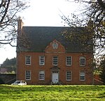 Upload another image | |||
| Bankton House, Colonel Gardiner's Monument | 55°57′13″N 2°58′15″W / 55.953587°N 2.970696°W / 55.953587; -2.970696 (Bankton House, Colonel Gardiner's Monument) | Category B | 17547 |  Upload another image | |||
| 5 Bridge Street | 55°56′41″N 2°57′16″W / 55.944792°N 2.954465°W / 55.944792; -2.954465 (5 Bridge Street) | Category C(S) | 42079 | Upload Photo | |||
| 205 Church Street, Seton Lodge With Retaining Walls, Railings And Gateways | 55°56′57″N 2°57′21″W / 55.949048°N 2.955947°W / 55.949048; -2.955947 (205 Church Street, Seton Lodge With Retaining Walls, Railings And Gateways) | Category B | 42084 |  Upload another image | |||
| 71 High Street | 55°56′37″N 2°57′07″W / 55.943732°N 2.952069°W / 55.943732; -2.952069 (71 High Street) | Category C(S) | 42097 | Upload Photo | |||
| Sanderson's Wynd, Tranent Infant School With Gates And Gatepiers, Retaining Walls And Shelters | 55°56′46″N 2°57′13″W / 55.946219°N 2.953523°W / 55.946219; -2.953523 (Sanderson's Wynd, Tranent Infant School With Gates And Gatepiers, Retaining Walls And Shelters) | Category B | 42099 |  Upload another image | |||
| Elphinstone Tower With Gatepiers And Garden Walls | 55°55′08″N 2°58′39″W / 55.918752°N 2.97741°W / 55.918752; -2.97741 (Elphinstone Tower With Gatepiers And Garden Walls) | Category B | 19069 | Upload Photo | |||
| St Germains Coach House | 55°57′44″N 2°55′14″W / 55.96213°N 2.92066°W / 55.96213; -2.92066 (St Germains Coach House) | Category B | 19072 | 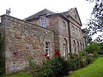 Upload another image | |||
| Seton Collegiate Church, St Mary And Holy Cross, With Retaining Walls And Carved Panels | 55°57′56″N 2°56′01″W / 55.965456°N 2.933587°W / 55.965456; -2.933587 (Seton Collegiate Church, St Mary And Holy Cross, With Retaining Walls And Carved Panels) | Category A | 19077 | Upload Photo | |||
| Seton West Mains Farmhouse With Garden Walls | 55°57′42″N 2°57′09″W / 55.961655°N 2.952461°W / 55.961655; -2.952461 (Seton West Mains Farmhouse With Garden Walls) | Category C(S) | 19082 | Upload Photo | |||
| 12 Church Street | 55°56′43″N 2°57′16″W / 55.945151°N 2.954522°W / 55.945151; -2.954522 (12 Church Street) | Category C(S) | 42087 | Upload Photo | |||
| 244 Church Street, The Manse Stables With Retaining Walls And Gatepiers | 55°56′58″N 2°57′24″W / 55.949358°N 2.956531°W / 55.949358; -2.956531 (244 Church Street, The Manse Stables With Retaining Walls And Gatepiers) | Category B | 42089 | Upload Photo | |||
| Seton Castle (Seton House), With Retaining Terrace And Walls | 55°57′55″N 2°56′06″W / 55.965212°N 2.934959°W / 55.965212; -2.934959 (Seton Castle (Seton House), With Retaining Terrace And Walls) | Category A | 19080 |  Upload another image | |||
| 8-10 (Even Numbers) Church Street | 55°56′42″N 2°57′16″W / 55.945053°N 2.954375°W / 55.945053; -2.954375 (8-10 (Even Numbers) Church Street) | Category C(S) | 42086 | Upload Photo | |||
| High Street, Tranent War Memorial And Railings | 55°56′41″N 2°57′13″W / 55.944592°N 2.953547°W / 55.944592; -2.953547 (High Street, Tranent War Memorial And Railings) | Category B | 42098 | 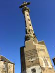 Upload another image | |||
| Tranent Parish Church (Church Of Scotland) With Graveyard Walls, Gatepiers, Gates And Gravestones | 55°56′59″N 2°57′29″W / 55.949733°N 2.958029°W / 55.949733; -2.958029 (Tranent Parish Church (Church Of Scotland) With Graveyard Walls, Gatepiers, Gates And Gravestones) | Category B | 42100 | 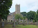 Upload another image | |||
| Fa'side Castle (or Falside Castle), With Outbuilding And Retaining Walls | 55°55′40″N 2°59′51″W / 55.927828°N 2.997516°W / 55.927828; -2.997516 (Fa'side Castle (or Falside Castle), With Outbuilding And Retaining Walls) | Category B | 19070 | 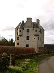 Upload another image | |||
| St Joseph's School With Gates And Gatepiers | 55°57′17″N 2°57′12″W / 55.954737°N 2.95346°W / 55.954737; -2.95346 (St Joseph's School With Gates And Gatepiers) | Category B | 19076 | Upload Photo | |||
| Tranent Mains Farmhouse | 55°57′04″N 2°56′54″W / 55.951119°N 2.948391°W / 55.951119; -2.948391 (Tranent Mains Farmhouse) | Category C(S) | 19083 | Upload Photo | |||
| Elphinstone, Main Street, War Memorial | 55°55′19″N 2°58′06″W / 55.921807°N 2.968349°W / 55.921807; -2.968349 (Elphinstone, Main Street, War Memorial) | Category C(S) | 17551 |  Upload another image | |||
| St Germains, East Lodge With Outbuilding, Quadrant And Gatepiers | 55°57′52″N 2°55′22″W / 55.964468°N 2.922766°W / 55.964468; -2.922766 (St Germains, East Lodge With Outbuilding, Quadrant And Gatepiers) | Category C(S) | 49601 | Upload Photo | |||
| 246 Church Street, With Balustrades And Retaining Walls | 55°56′59″N 2°57′24″W / 55.949716°N 2.9567°W / 55.949716; -2.9567 (246 Church Street, With Balustrades And Retaining Walls) | Category B | 42090 | Upload Photo | |||
| 252 Church Street | 55°57′00″N 2°57′23″W / 55.949916°N 2.956464°W / 55.949916; -2.956464 (252 Church Street) | Category B | 42091 | Upload Photo | |||
| Seton Farmhouse With Retaining Walls | 55°57′51″N 2°56′28″W / 55.964177°N 2.941101°W / 55.964177; -2.941101 (Seton Farmhouse With Retaining Walls) | Category C(S) | 19078 | Upload Photo | |||
| Dovecot Brae, Tranent Dovecot | 55°57′00″N 2°57′29″W / 55.950119°N 2.958055°W / 55.950119; -2.958055 (Dovecot Brae, Tranent Dovecot) | Category B | 17549 | 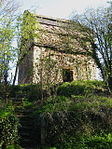 Upload another image | |||
| Elphinstone, Main Street, Chapel | 55°55′16″N 2°58′14″W / 55.921189°N 2.97043°W / 55.921189; -2.97043 (Elphinstone, Main Street, Chapel) | Category C(S) | 17550 | 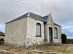 Upload another image | |||
| 23 Bridge Street, Royal Bank Of Scotland | 55°56′41″N 2°57′18″W / 55.944797°N 2.954961°W / 55.944797; -2.954961 (23 Bridge Street, Royal Bank Of Scotland) | Category B | 42080 | Upload Photo | |||
| Church Street, House By Parish Church Hall | 55°56′49″N 2°57′17″W / 55.947027°N 2.954808°W / 55.947027; -2.954808 (Church Street, House By Parish Church Hall) | Category B | 42081 | Upload Photo | |||
| High Street, East Lothian Co-Operative Society Ltd | 55°56′41″N 2°57′14″W / 55.944859°N 2.953874°W / 55.944859; -2.953874 (High Street, East Lothian Co-Operative Society Ltd) | Category C(S) | 42096 | Upload Photo | |||
| St Germains Cottage | 55°57′43″N 2°55′13″W / 55.962052°N 2.920258°W / 55.962052; -2.920258 (St Germains Cottage) | Category C(S) | 19073 | Upload Photo | |||
| Bankton House Garden House/Dovecot | 55°57′08″N 2°58′15″W / 55.952157°N 2.970933°W / 55.952157; -2.970933 (Bankton House Garden House/Dovecot) | Category C(S) | 17548 |  Upload another image | |||
| Church Street, Parish Church Hall (Formerly Wishart Church) With Gates, Railings, Gatepiers And Retaining Walls | 55°56′49″N 2°57′16″W / 55.946939°N 2.954486°W / 55.946939; -2.954486 (Church Street, Parish Church Hall (Formerly Wishart Church) With Gates, Railings, Gatepiers And Retaining Walls) | Category B | 42082 | Upload Photo | |||
| 4-6 (Even Numbers) Church Street | 55°56′42″N 2°57′16″W / 55.944945°N 2.954404°W / 55.944945; -2.954404 (4-6 (Even Numbers) Church Street) | Category C(S) | 42085 | Upload Photo | |||
| 7 Edinburgh Road With Gates And Gatepiers | 55°56′45″N 2°57′40″W / 55.94573°N 2.960973°W / 55.94573; -2.960973 (7 Edinburgh Road With Gates And Gatepiers) | Category C(S) | 42094 | Upload Photo | |||
| St Clements Wells Dovecot | 55°55′52″N 3°00′13″W / 55.931202°N 3.003605°W / 55.931202; -3.003605 (St Clements Wells Dovecot) | Category B | 19071 |  Upload another image | |||
| St Germains Dovecot | 55°57′39″N 2°55′14″W / 55.960702°N 2.920546°W / 55.960702; -2.920546 (St Germains Dovecot) | Category B | 19074 |  Upload another image | |||
| Seton Gardens With Retaining Walls And Gatepiers | 55°57′49″N 2°56′00″W / 55.963734°N 2.933241°W / 55.963734; -2.933241 (Seton Gardens With Retaining Walls And Gatepiers) | Category C(S) | 19079 | Upload Photo | |||
| Seton Mill Kiln And Granary | 55°58′02″N 2°56′10″W / 55.967262°N 2.936017°W / 55.967262; -2.936017 (Seton Mill Kiln And Granary) | Category C(S) | 19081 |  Upload another image |
Key
The scheme for classifying buildings in Scotland is:
- Category A: "buildings of national or international importance, either architectural or historic; or fine, little-altered examples of some particular period, style or building type."[1]
- Category B: "buildings of regional or more than local importance; or major examples of some particular period, style or building type, which may have been altered."[1]
- Category C: "buildings of local importance; lesser examples of any period, style, or building type, as originally constructed or moderately altered; and simple traditional buildings which group well with other listed buildings."[1]
In March 2016 there were 47,288 listed buildings in Scotland. Of these, 8% were Category A, and 50% were Category B, with the remaining 42% being Category C.[2]
See also
Notes
- ^ Sometimes known as OSGB36, the grid reference (where provided) is based on the British national grid reference system used by the Ordnance Survey.
• "Guide to National Grid". Ordnance Survey. Retrieved 12 December 2007.
• "Get-a-map". Ordnance Survey. Retrieved 17 December 2007. - ^ Historic Environment Scotland assign a unique alphanumeric identifier to each designated site in Scotland, for listed buildings this always begins with "LB", for example "LB12345".
References
- All entries, addresses and coordinates are based on data from Historic Scotland. This data falls under the Open Government Licence
- ^ a b c "What is Listing?". Historic Environment Scotland. Retrieved 29 May 2018.
- ^ Scotland's Historic Environment Audit 2016 (PDF). Historic Environment Scotland and the Built Environment Forum Scotland. pp. 15–16. Retrieved 29 May 2018.


