List of national parks of Pakistan
Pakistan has 36 national parks (Urdu: پاکستان کے نیشنل پارک). As of 2012, 25 of these are under supervision of respective provincial governments and remaining are in private care.[1] Only some of these are under the conservation scope of International Union for Conservation of Nature. Protection and conservation of the environment of Pakistan was included in the concurrent constitution of 1973. As a result, Environment Protection Ordinance was enacted in 1983, which was mainly regulated by the Environment and Urban Affairs Division. Later, a new system of 'Modern Protected Areas' legislation began at the provincial level which assigned the protected areas with designations such as national parks, wildlife sanctuaries and game reserves. Further recommendations of the national parks of the Indomalayan realm were highlighted in the IUCN review of 1986.[2] Nevertheless, the development of national parks was mainly carried out by National Conservation Strategy of 1992. Due to more awareness about their importance in conservation of biodiversity, 10 national parks have been established during the time period from 1993 to 2005.[1]
According to the 'Modern Protected Areas' legislation, a national park is a protected area set aside by the government for the protection and conservation of its outstanding scenery and wildlife in a natural state. It is accessible to public for research, education and recreation. In order to promote public use, construction of roads and rest houses is permitted. Use of firearms, polluting water, cleaning of land for cultivation, destruction of wildlife is banned in these areas.[3]
The oldest national park is Lal Suhanra in Bahawalpur District, established in 1972.[4] It is also the only biosphere reserve of Pakistan. Lal Suhanra is the only national park established before the independence of the nation in August 1947. The main purpose of this area was to protect the wildlife of Cholistan Desert.[3] Central Karakoram in Gilgit-Baltistan is currently the largest national park in the country, spanning over a total approximate area of 1,390,100 hectares (3,435,011.9 acres). The smallest national park is the Ayubia, covering a total approximate area of 3,312 hectares (8,184.1 acres).
| National Parks of Pakistan | |
  1  2 3 valley  4 5 6 7  8 9 10  11 12 13 14 15  16 17 18 19  20 21 22 23 24 25 26 27 28 class=notpageimage| Click on a 'mark' to open the article of the respective national park |
|


National parks
| S.No | National park | Established | Area | District(s) | Province | Coordinates |
|---|---|---|---|---|---|---|
| 1 | Himalaya National Park | 2020[5] | 198,900 ha (491,493 acres)[6] | Astore District | Gilgit Baltistan | 35°21′01″N 74°51′32″E / 35.350277777778°N 74.858888888889°E / 35.350277777778; 74.858888888889 (Himalaya National park) |
| 2 | Hundrap-Shandur National Park | 1993[7] | 3,312 ha (8,184 acres)[6] | Gupis-Yasin | Gilgit Baltistan | 33°51′55″N 73°08′20″E / 33.865231°N 73.138768°E / 33.865231; 73.138768 (Shandure-Phander National Park) |
| 3 | Nanga Parbat National Park | 2020[5] | 1,611 ha (3,981 acres)[6] | Astore District | Gilgit Baltistan | 35°21′01″N 74°51′32″E / 35.350277777778°N 74.858888888889°E / 35.350277777778; 74.858888888889 (Nanga National park) |
| 4 | Broghil Valley | 2010[8] | 134,744 ha (332,960 acres)[8] | Chitral | Khyber Pakhtunkhwa | 36°50′28″N 73°20′09″E / 36.841164°N 73.335697°E / 36.841164; 73.335697 (Broghil Valley National Park) |
| 5 | Central Karakoram | 1993[3] | 1,390,100 ha (3,435,012 acres)[1] | Hunza-Nagar and Shigar | Gilgit Baltistan | 36°53′52″N 75°05′37″E / 36.897708°N 75.093545°E / 36.897708; 75.093545 (Central Karakoram National Park) |
| 6 | Chinji | 1987[3] | 6,095 ha (15,061 acres)[1] | Chakwal | Punjab | 33°00′37″N 72°29′31″E / 33.010242°N 72.491940°E / 33.010242; 72.491940 (Chinji National Park) |
| 7 | Chitral Gol | 1984[3] | 7,750 ha (19,151 acres)[1] | Chitral | Khyber Pakhtunkhwa | 35°55′59″N 71°40′14″E / 35.933082°N 71.670693°E / 35.933082; 71.670693 (Chitral Gol National Park) |
| 8 | Deosai | 1993[3] | 358,400 ha (885,626 acres)[1] | Skardu | Gilgit Baltistan | 34°58′21″N 75°23′47″E / 34.972626°N 75.396423°E / 34.972626; 75.396423 (Deosai National Park) |
| 9 | Deva Vatala | 2009[4] | 2,993 ha (7,396 acres)[9] | Bhimber | Azad Kashmir | 32°53′33″N 74°18′11″E / 32.892583°N 74.303172°E / 32.892583; 74.303172 (Deva Vatala National Park) |
| 10 | Gumot | 2004[10] | 27,271 ha (67,388 acres)[9] | Neelum | Azad Kashmir | 35°00′25″N 74°12′01″E / 35.006943°N 74.200287°E / 35.006943; 74.200287 (Gumot National Park) |
| 11 | Musk Deer National Park | 2009[11] | 52,815 ha (130,509 acres)[9] | Neelum | Azad Kashmir | 34°43′53″N 74°47′12″E / 34.731456°N 74.786682°E / 34.731456; 74.786682 (Gurez National Park) |
| 12 | Hazarganji-Chiltan | 1980[3] | 15,555 ha (38,437 acres)[1] | Quetta | Balochistan | 30°17′09″N 67°12′08″E / 30.285695°N 67.202298°E / 30.285695; 67.202298 (Hazarganji-Chiltan National Park) |
| 13 | Hingol | 1988[3] | 165,004 ha (407,734 acres)[1] | Awaran, Gwadar and Lasbela | Balochistan | 25°31′34″N 65°05′10″E / 25.526246°N 65.085996°E / 25.526246; 65.085996 (Hingol National Park) |
| 14 | K2 | — | 233,468 ha (576,912 acres)[12] | Gilgit, Skardu | Gilgit Baltistan | 35°47′17″N 76°10′58″E / 35.788171°N 76.182888°E / 35.788171; 76.182888 (K2 National Park) |
| 15 | Kala Chitta | 2009[4] | 36,965 ha (91,343 acres)[13] | Attock | Punjab | 33°38′34″N 72°24′03″E / 33.642685°N 72.400824°E / 33.642685; 72.400824 (Kala Chitta National Park) |
| 16 | Khunjerab | 1975[3] | 226,913 ha (560,714 acres)[1] | Hunza | Gilgit Baltistan | 36°30′03″N 75°38′37″E / 36.500805°N 75.643616°E / 36.500805; 75.643616 (Khunjerab National Park) |
| 17 | Kirthar | 1974[3] | 308,733 ha (762,896 acres)[1] | Dadu | Sindh | 25°39′29″N 67°32′56″E / 25.658107°N 67.548975°E / 25.658107; 67.548975 (Kirthar National Park) |
| 18 | Lal Suhanra | 1972[4] | 87,426 ha (216,034 acres)[1] | Bahawalpur | Punjab | 29°23′51″N 72°01′33″E / 29.397409°N 72.025811°E / 29.397409; 72.025811 (Lal Suhanra National Park) |
| 19 | Lulusar-Dudipatsar | 2003[3] | 30,375 ha (75,058 acres)[3] | Mansehra | Khyber Pakhtunkhwa | 35°05′27″N 73°55′47″E / 35.090698°N 73.929749°E / 35.090698; 73.929749 (Lulusar-Dudipatsar National Park) |
| 20 | Machiara | 1996[3] | 13,532 ha (33,438 acres)[9] | Muzaffarabad | Azad Kashmir | 34°30′24″N 73°33′55″E / 34.506557°N 73.565140°E / 34.506557; 73.565140 (Machiara National Park) |
| 21 | Manglot National Park | 1990[3] | 710.628 ha (1,756 acres) | Nowshera | Khyber Pakhtunkhwa | 36°06′N 73°14′E / 36.10°N 73.23°E / 36.10; 73.23 (Manglot National Park) |
| 22 | Margalla Hills | 1980[3] | 17,386 ha (42,962 acres)[1] | Islamabad, Rawalpindi | Punjab | 33°45′16″N 72°57′23″E / 33.754317°N 72.956429°E / 33.754317; 72.956429 (Margalla Hills National Park) |
| 23 | Murree Kotli Sattian Kahuta National Park | 2009[8] | 57,581 ha (142,286 acres)[14] | Rawalpindi | Punjab | 33°44′21″N 73°28′17″E / 33.739032°N 73.471344°E / 33.739032; 73.471344 (Murree Kotli Sattian Kahuta National Park) |
| 24 | Pir Lasura | 2005[3] | 5,625 ha (13,900 acres)[1] | Kotli | Azad Kashmir | 33°38′21″N 73°50′48″E / 33.639204°N 73.846664°E / 33.639204; 73.846664 (Pir Lasura National Park) |
| 25 | Poonch River Mahaseer | 2010[8] | 4,500 ha (11,120 acres)[8] | Kotli, Mirpur and Poonch | Azad Kashmir | 33°33′19″N 73°54′58″E / 33.555272°N 73.91599°E / 33.555272; 73.91599 (Poonch River Mahaseer National Park) |
| 26 | Qurumber | 2011[8] | 74,000 ha (182,858 acres)[8] | Ghizer | Gilgit-Baltistan | 36°51′47″N 73°46′52″E / 36.863141°N 73.781038°E / 36.863141; 73.781038 (Qurumber National Park) |
| 27 | Saiful Muluk | 2003[3] | 4,867 ha (12,027 acres)[3] | Mansehra | Khyber Pakhtunkhwa | 34°52′51″N 73°41′54″E / 34.880862°N 73.698349°E / 34.880862; 73.698349 (Saiful Muluk National Park) |
| 28 | Sheikh Badin | 1993[3] | 15,540 ha (38,400 acres)[1] | Dera Ismail Khan | Khyber Pakhtunkhwa | 32°22′56″N 70°56′59″E / 32.382281°N 70.949707°E / 32.382281; 70.949707 (Sheikh Badin National Park) |
| 29 | Toli Pir | 2005[3] | 5,045 ha (12,466 acres)[1] | Poonch | Azad Kashmir | 34°07′15″N 73°37′59″E / 34.12090°N 73.633118°E / 34.12090; 73.633118 (Toli Pir National Park) |
| 30 | Panjal Mastan National Park | 2005[3] | 5,045 ha (12,466 acres)[1] | Bagh District | Azad Kashmir | 34°03′27″N 73°44′17″E / 34.0574°N 73.7381°E / 34.0574; 73.7381 (Panjal Mastan National Park) |
| 31 | Fairy Meadows National Park | 1995[15] | 10,000 ha (24,711 acres)[1] | Diamer District | Gilgit-Baltistan | 35°21′01″N 74°51′32″E / 35.350277777778°N 74.858888888889°E / 35.350277777778; 74.858888888889 (Fairy Meadows National Park) |
| 32 | Salt Range National Park | 2021[16] | 13,700 ha (33,853 acres)[1] | Chakwal District | Punjab | 32°49′56″N 72°36′54″E / 32.8322°N 72.6151°E / 32.8322; 72.6151 (Salt Range National Park) |
| 33 | Tilla Joggian National Park | 2021[17] | 8,840 ha (21,844 acres)[1] | Jhelum District | Punjab | 32°56′33″N 73°43′33″E / 32.9425°N 73.7257°E / 32.9425; 73.7257 (Tilla Joggian National Park) |
| 34 | Koh-e-Sulaiman National Park | 2021[18] | 30,000 ha (74,132 acres)[1] | Dera Ismail Khan | Khyber Pakhtunkhwa | 32°00′00″N 70°17′45″E / 32.0000°N 70.2959°E / 32.0000; 70.2959 (Koh-e-Sulaiman National Park) |
| 35 | Ziarat National Park | 2021[19] | 21,450 ha (53,004 acres)[1] | Ziarat | Balochistan | 30°23′38″N 67°43′01″E / 30.3939°N 67.7169°E / 30.3939; 67.7169 (Ziarat National Park) |
| 36 | Pabbi National Park | Gujrat | Punjab | |||
| 37 | Greater Thar National Park | Sindh | ||||
| 38 | Mianghundi Recreational Park | Quetta | Balochistan | |||
| 39 | Kheri Murat National Park | Attock | Punjab | |||
| 40 | Kundian Forest Park | Mianwali District | Punjab | |||
| 41 | Qazi Nag National Park | Hattian Bala District | Azad Kashmir | |||
| 42 | Thub Patri National Park | Bhimber District | Azad Kashmir |
Pictures
Wikimedia Commons has media related to National parks of Pakistan.
-
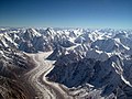 Baltoro glacier is found in Central Karakoram National Park
 -
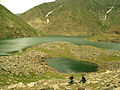
 Plain of Deosai National Park
 -
 Mud volcano in Hingol National Park
 -
-

-

-
-
 Cold water spring of Kirthar National Park


See also
References
- ^ a b c d e f g h i j k l m n o p q r s t u "Review of 'Protected Areas System' in Pakistan: Present status and problems concerning future development (Page 8, 9, 15)" (PDF). dergiler.ankara.edu.tr. Ankara University. 2010. Retrieved September 8, 2010.
- ^ "Pakistan Protected Areas: Meeting Proceedings" (PDF). iucn.pk. IUCN, Pakistan. 1994. Retrieved September 29, 2010.
- ^ a b c d e f g h i j k l m n o p q r s t u "Country Report on Plant Genetic Resources for Food and Agriculture – Pakistan" (PDF). parc.gov.pk. Pakistan Agricultural Research Council. Archived from the original (PDF) on January 18, 2012. Retrieved September 8, 2010.
- ^ a b c d "Canadian Journal of Pure and Applied Sciences, an international journal: Current issue (Number: 4, Volume: 2, June 2010) Online ISSN 1920-3853" (PDF). cjpas.net. SENRA Academic Publishers, Burnaby, British Columbia. 2010. Archived from the original (PDF) on June 16, 2011. Retrieved September 8, 2010.
- ^ a b "PM inaugurates two national parks in Gilgit-Baltistan". Pakistan Today. 2 December 2020. Retrieved 23 September 2022.
- ^ a b c "Improving Sub-Watershed Management and Environmental Awareness in the Ayubia National Park". wwf.panda.org. WWF -Pakistan.
- ^ "Hundrap National Park - Forest, Wildlife & Environment Department Government of Gilgit-Baltistan". 20 January 2022.
- ^ a b c d e f g "List of National Parks in Pakistan". pakwildlife.org. Archived from the original on January 11, 2013. Retrieved December 7, 2012.
- ^ a b c d "Protected areas of AJK". forest.ajk.gov.pk. Government of Azad and Jammu Kashmir. 2009. Archived from the original on September 21, 2010. Retrieved September 7, 2010.
- ^ "(Fourth national report) Biodiversity of Pakistan: Status trends and threats" (PDF). cbd.int. Convention on Biological Diversity, International. Retrieved September 8, 2010.
- ^ "Musk Deer National Park, Guraiz (MDNPG) conflict: Who is responsible?". kashmirnewswatch.com. Kashmir News Watch. Archived from the original on April 15, 2011. Retrieved September 8, 2010.
- ^ "National Parks in Pakistan". wdpa.org. World Database on protected Areas. Retrieved September 8, 2010.[permanent dead link]
- ^ "List of National Parks of Pakistan". pakwildlife.org. Archived from the original on December 31, 2011. Retrieved January 16, 2012.
- ^ "National Assembly Secretariat - "Questions for oral answers and their replies"" (PDF). cybervision.com. April 20, 2011. p. 26. Retrieved December 7, 2012.[permanent dead link]
- ^ Lawrence S. Hamilton (15 June 1995). "New Parks for Pakistan" (PDF). Mountain Protected Areas Update. International Union for Conservation of Nature. p. 3. Archived from the original (PDF) on 28 August 2013. Retrieved 28 August 2013.
- ^ Asghar, Hamid (2021-03-01). "Pakistan offers unique, diverse opportunities for tourism: Imran". Dawn. Retrieved 2022-09-22.
- ^ "Tilla Jogian gets 'national park' status". The Express Tribune. 2022-02-14. Retrieved 2022-09-22.
- ^ "Koh-e-Sulaiman to emerge as Pakistan's first transboundary park". The Express Tribune. 2021-07-02. Retrieved 2022-09-22.
- ^ "Ziarat to be declared national park". The Express Tribune. 2021-08-26. Retrieved 2022-09-22.
- v
- t
- e

- Ayub
- Ayubia
- Broghil Valley
- Central Karakoram
- Chinji
- Chitral Gol
- Deosai
- Deva Vatala
- Fairy Meadows
- Gumot
- Hazarganji-Chiltan
- Hingol
- Kala Chitta
- Kamal Ban
- Khunjerab
- Kirthar
- Lal Suhanra
- Lulusar-Dodipat
- Machiara
- Malakandi
- Margalla Hills
- Nizampur
- Panjal Mastan
- Saiful Muluk
- Shandur
- Sheikh Badin
- Tolipir
- Manglot
- Astola Island
- Chashma Barrage
- Chinna Creek
- Drigh Lake
- Rann of Kutch
- Haleji Lake
- Hawke's Bay Beach
- Hingol River
- Hub Dam
- Indus River Delta
- Jiwani Coastal Wetland
- Jubho Lagoon
- Keti Bandar
- Khanpur Dam
- Keenjhar Lake
- Miani Hor
- Ormara Turtle Beaches
- Rasul Barrage
- Rawal lake
- Sandspit Beach
- Tanda Dam
- Taunsa Barrage
- Thanedar Wala
- Uchhali Complex
Pakistan articles | |||||||||||||||||||
|---|---|---|---|---|---|---|---|---|---|---|---|---|---|---|---|---|---|---|---|
| |||||||||||||||||||
| |||||||||||||||||||
| |||||||||||||||||||
| |||||||||||||||||||
| |||||||||||||||||||
| |||||||||||||||||||


List of national parks of Asia | |
|---|---|
| Sovereign states |
|
| States with limited recognition |
|
| Dependencies and other territories |
|
| |


