List of places on the Victorian Heritage Register in the City of Brimbank
This is a list of places on the Victorian Heritage Register in the City of Brimbank in Victoria, Australia. The Victorian Heritage Register is maintained by the Heritage Council of Victoria.
The Victorian Heritage Register, as of 2020, lists the following 13 state-registered places within the City of Brimbank:[1]
| Place name | Place # | Location | Suburb or Town | Co-ordinates | Built | Stateregistered | Photo |
|---|---|---|---|---|---|---|---|
| Albion Viaduct | H1197 | over the Maribyrnong River | Keilor East and Sunshine North | 37°44′49″S 144°50′47″E / 37.747020°S 144.846520°E / -37.747020; 144.846520 | 1927-29 | 19 September 1996 | 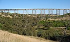 |
| Arundel Road Trestle Bridge | H1952 | over the Maribyrnong River | Keilor | 37°42′14″S 144°49′58″E / 37.703910°S 144.832770°E / -37.703910; 144.832770 | 1906-07 | 13 September 2001 | |
| Black Powder Mill | H2029 | Parklea Ave and Grassy Point Rd | Cairnlea | 37°45′49″S 144°46′41″E / 37.763550°S 144.778040°E / -37.763550; 144.778040 | 1939 | 12 June 2003 | |
| H.V. McKay Memorial Gardens | H1953 | Anderson Rd | Sunshine | 37°47′01″S 144°49′42″E / 37.783660°S 144.828280°E / -37.783660; 144.828280 | 1909 | 13 September 2001 |  |
| H.V. McKay Offices | H1966 | 2 Devonshire Rd | Sunshine | 37°47′06″S 144°49′51″E / 37.785083°S 144.830972°E / -37.785083; 144.830972 | 1909 | 21 March 2002 | |
| Iron Bridge | H1427 | over Maribyrnong River | Keilor and Keilor East | 37°43′26″S 144°50′26″E / 37.723750°S 144.840444°E / -37.723750; 144.840444 | 1868 | 20 August 1982 |  |
| John Darling and Son Flour Mill | H0829 | 74 Sydney St | Albion | 37°46′40″S 144°49′25″E / 37.777770°S 144.823730°E / -37.777770; 144.823730 | 1922 | 23 January 1991 | 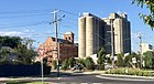 |
| Keilor Hotel | H1974 | 670-674 Old Calder Hwy | Keilor | 37°43′11″S 144°50′11″E / 37.719700°S 144.836380°E / -37.719700; 144.836380 | 1848 | 14 February 2002 | 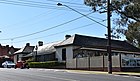 |
| Main Outfall Sewer | H1932 | Cypress Ave | Brooklyn | 37°49′18″S 144°50′33″E / 37.821620°S 144.842470°E / -37.821620; 144.842470 | 1892-94 | 13 September 2001 | |
| Massey Ferguson Complex | H0667 | Devonshire Rd, Hampshire Rd and Harvester Rd | Sunshine | 37°46′55″S 144°49′52″E / 37.781960°S 144.831030°E / -37.781960; 144.831030 | 1927 | 10 February 1988 | |
| Overnewton | H0200 | 51 Overnewton Rd | Keilor | 37°42′17″S 144°49′15″E / 37.704840°S 144.820800°E / -37.704840; 144.820800 | 1849 | 9 October 1974 | 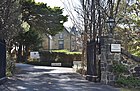 |
| Overnewton Gatehouse | H1947 | 804-804A Old Calder Hwy | Keilor | 37°42′34″S 144°49′13″E / 37.709420°S 144.820400°E / -37.709420; 144.820400 | c. 1859 | 12 July 2001 |  |
| Prefabricated Building | H1971 | 152 Harrick Rd | Keilor Park | 37°43′14″S 144°50′48″E / 37.720540°S 144.846750°E / -37.720540; 144.846750 | c. 1850s | 14 February 2002 |
References
- ^ "Brimbank". Victorian Heritage Database. Heritage Council of Victoria. Retrieved 6 April 2020.
- v
- t
- e
Places listed on the Victorian Heritage Register by local government area
| Greater Melbourne region |
|
|---|
| Barwon South West region |
|
|---|---|
| Gippsland region | |
| Grampians region |
|
| Hume region |
|
| Loddon Mallee region |
|


