List of protected heritage sites in Sankt-Vith
This table shows an overview of the protected heritage sites in the Walloon town Sankt-Vith. This list is part of Belgium's national heritage.
| Object | Year/architect | Town/section | Address | Coordinates | Number | Image |
|---|---|---|---|---|---|---|
| Mother of God Church in Neundorf (nl) (de) | Crombach Sankt Vith | 50°16′03″N 6°05′33″E / 50.267573°N 6.092467°E / 50.267573; 6.092467 | 31033 Info |  | ||
| Old school: the walls and roof, except that part built in 1911, the vaulted cellar, its stairs and spring (nl) (de) | Sankt Vith | 50°18′15″N 6°06′13″E / 50.304237°N 6.103519°E / 50.304237; 6.103519 | 31035 Info |  | ||
| Church St. Aldegundis: tower with its onion-dome and neighboring buildings from the 18th century, the choir with windows, roof, pillars, columns and pilasters (nl) (de) | Sankt Vith | 50°20′06″N 6°02′36″E / 50.334974°N 6.043348°E / 50.334974; 6.043348 | 31037 Info |  | ||
| Maria Chapel (nl) (de) | Sankt Vith | 50°20′15″N 6°02′39″E / 50.337611°N 6.044053°E / 50.337611; 6.044053 | 31038 Info | 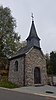 | ||
| Bakery (nl) (de) | Sankt Vith | 50°19′31″N 6°03′36″E / 50.325308°N 6.060021°E / 50.325308; 6.060021 | 31036 Info |  | ||
| Sheep Bridge (Schapenbrug) (nl) (de) | Sankt Vith | 50°19′59″N 6°02′11″E / 50.333134°N 6.036273°E / 50.333134; 6.036273 | 31039 Info |  | ||
| Rodter Buchen (nl) (de) | Sankt Vith | 50°17′20″N 6°03′35″E / 50.288883°N 6.059663°E / 50.288883; 6.059663 | 31050 Info |  | ||
| Saint Anthony's Church tower and choir (nl) (de) | Sankt Vith | 50°15′33″N 6°04′06″E / 50.259251°N 6.068384°E / 50.259251; 6.068384 | 31026 Info | 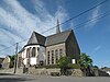 | ||
| St. Lawrence Church and Vrijthof wall in Mackenbach (nl) (de) | Sankt Vith | 50°17′01″N 6°13′45″E / 50.283690°N 6.229179°E / 50.283690; 6.229179 | 31034 Info |  | ||
| Büchelturm tower gate (nl) (de) | Sankt Vith | 50°16′47″N 6°07′29″E / 50.279658°N 6.124843°E / 50.279658; 6.124843 | 31040 Info |  | ||
| Antoniusbaum area (nl) (de) | Sankt Vith | 50°16′48″N 6°11′14″E / 50.279986°N 6.187193°E / 50.279986; 6.187193 | 31049 Info | 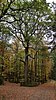 | ||
| Castle Wallerode (walls and roof) (nl) (de) | Recht Sankt Vith | 50°17′49″N 6°09′19″E / 50.296960°N 6.155279°E / 50.296960; 6.155279 | 31003 Info | 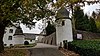 | ||
| St. Bartholomew's Chapel in Wiesenbach with 13 linden trees, cemetery and wall (nl) (de) | Lommersweiler Sankt Vith | Wiesenbach | 50°15′54″N 6°08′29″E / 50.265022°N 6.141518°E / 50.265022; 6.141518 | 30998 Info |  | |
| The Belgian-Prussian border markers 93-111 (several municipalities) (nl) (de) | Sankt Vith | 50°18′31″N 6°00′47″E / 50.308639°N 6.013061°E / 50.308639; 6.013061 | 31215 Info | |||
| Tumulus Schinkelsknopf (nl) (de) | Sankt Vith Sankt Vith | 50°15′12″N 6°06′48″E / 50.253305°N 6.113399°E / 50.253305; 6.113399 | 31299 Info |  | ||
| Burial mound "An bzw. Auf der Lie" (nl) (de) | Sankt Vith | 50°15′55″N 6°06′12″E / 50.265386°N 6.103370°E / 50.265386; 6.103370 | 31490 Info |  |
See also
- Lists of protected heritage sites in the German-speaking Community of Belgium
- List of protected heritage sites in Liège (province)
- Sankt-Vith
Wikimedia Commons has media related to Cultural heritage monuments in Sankt-Vith.
References
- Belgian heritage register: Direction générale opérationnelle - Aménagement du territoire, Logement, Patrimoine et Energie (DG4)[1]
- www.dglive.be
- Geschützte Objekte in St. Vith


