Miankuh-e Moguyi Rural District
Rural district in Chaharmahal and Bakhtiari province, Iran
Rural District in Chaharmahal and Bakhtiari, Iran
Miankuh-e Moguyi Rural District Persian: دهستان ميان كوه موگوئي | |
|---|---|
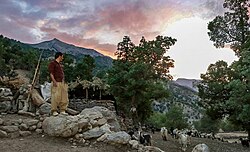 Landscape in the village of Biabeh | |
| 32°41′47″N 49°49′02″E / 32.69639°N 49.81722°E / 32.69639; 49.81722[1] | |
| Country | Iran |
| Province | Chaharmahal and Bakhtiari |
| County | Kuhrang |
| District | Central |
| Capital | Khuyeh |
| Population (2016)[2] | |
| • Total | 3,992 |
| Time zone | UTC+3:30 (IRST) |
Miankuh-e Moguyi Rural District (Persian: دهستان ميان كوه موگوئي) is in the Central District of Kuhrang County, Chaharmahal and Bakhtiari province, Iran.[3] Its capital is the village of Khuyeh.[4]
Demographics
Population
At the time of the 2006 National Census, the rural district's population was 3,781 in 624 households.[5] There were 3,570 inhabitants in 754 households at the following census of 2011.[6] The 2016 census measured the population of the rural district as 3,992 in 917 households. The most populous of its 16 villages was Sar Aqa Seyyed, with 1,698 people.[2]
Gallery
-
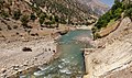 Biabeh village
 -
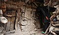 Biabeh village
 -
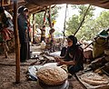 Biabeh village


See also
 Iran portal
References
- ^ OpenStreetMap contributors (30 August 2024). "Miankuh-e Moguyi Rural District (Kuhrang County)" (Map). openstreetmap.org (OpenStreetMap) (in Persian). Retrieved 30 August 2024.
- ^ a b Census of the Islamic Republic of Iran, 1395 (2016): Chaharmahal and Bakhtiari Province. amar.org.ir (Report) (in Persian). The Statistical Center of Iran. Archived from the original (Excel) on 24 May 2019. Retrieved 19 December 2022.
- ^ Habibi, Hassan (c. 2023) [Approved 27 April 1380]. Approval letter regarding the establishment of Kuhrang County. lamtakam.com (Report) (in Persian). Ministry of the Interior, Council of Ministers. Proposal 1.4.42.3141. Archived from the original on 3 December 2023. Retrieved 3 December 2023 – via Lam ta Kam.
- ^ Habibi, Hassan (c. 2018) [Approved 12 December 1371]. Creation of 48 rural districts in several rural areas of the country. qavanin.ir (Report) (in Persian). Ministry of the Interior, Political-Defense Commission of the Government Council. Resolution 93808/T907. Archived from the original on 28 November 2018. Retrieved 2 January 2024 – via Laws and Regulations Portal of the Islamic Republic of Iran.
- ^ Census of the Islamic Republic of Iran, 1385 (2006): Chaharmahal and Bakhtiari Province. amar.org.ir (Report) (in Persian). The Statistical Center of Iran. Archived from the original (Excel) on 20 September 2011. Retrieved 25 September 2022.
- ^ Census of the Islamic Republic of Iran, 1390 (2011): Chaharmahal and Bakhtiari Province. irandataportal.syr.edu (Report) (in Persian). The Statistical Center of Iran. Archived from the original (Excel) on 16 January 2023. Retrieved 19 December 2022 – via Iran Data Portal, Syracuse University.
- v
- t
- e

| Ardal County | |
|---|---|
| Borujen County | |
| Ben County | |
| Falard County | |
| Farsan County | |
| Khanmirza County | |
| Kiar County | |
| Kuhrang County | |
| Lordegan County | |
| Saman County | |
| Shahrekord County |
- Zaneh Hafshejan Fountain Walkway
- Atashgah waterfall
- Kuhrang waterfall
- Shahrekord mirror room
- Emamzadeh Shahsavar
- Zamankhan bridge
- Babaheydar ski resort
- Chelgerd ski resort
- Gerdehkhalak ski resort
- Gandoman lagoon
- Sardab spring
- Suadeh building
- Samsaam al Salteneh castle
- Khan Mosque
- Cheleshtar Museum and castle

 | This Kuhrang County location article is a stub. You can help Wikipedia by expanding it. |
- v
- t
- e


