Millingen aan de Rijn
Town and former municipality in Gelderland, Netherlands

Flag

Coat of arms

Location in Gelderland
(August 2017)
6566
Millingen aan de Rijn (Dutch pronunciation: [ˈmɪlɪŋə(n) aːn də ˈrɛin] ⓘ) is a former municipality and a town in the eastern Netherlands, on thr border with Germany. It merged into the enlarged municipality of Groesbeek on 1 January 2015, renamed Berg en Dal from 1 January 2016.[3]

-
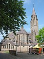 Sint Antonius Church

References
- ^ "Kerncijfers wijken en buurten 2020" [Key figures for neighbourhoods 2020]. StatLine (in Dutch). CBS. 24 July 2020. Retrieved 19 September 2020.
- ^ "Postcodetool for 6566EG". Actueel Hoogtebestand Nederland (in Dutch). Het Waterschapshuis. Archived from the original on 21 September 2013. Retrieved 10 July 2014.
- ^ "Gemeente Berg en Dal". internetgemeentegids.nl (in Dutch). Retrieved 4 July 2024.
External links
 Media related to Millingen aan de Rijn at Wikimedia Commons
Authority control databases | |
|---|---|
| International |
|
| National |
|
 | This Gelderland location article is a stub. You can help Wikipedia by expanding it. |
- v
- t
- e


