Montrose Micropolitan Statistical Area
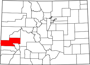
The Montrose Micropolitan Statistical Area is a United States Census Bureau defined Micropolitan Statistical Area located in the Montrose area of the State of Colorado. The Montrose Micropolitan Statistical Area is defined as Montrose County, Colorado. The Micropolitan Statistical Area had a population of 33,432 at the 2000 Census. A July 1, 2009 U.S. Census Bureau estimate placed the population at 41,412.[1]
The Montrose Micropolitan Statistical Area includes the City of Montrose, the Town of Naturita, the Town of Nucla, the Town of Olathe, and the unincorporated areas of Montrose County.
See also
- Montrose County, Colorado
- List of statistical areas in Colorado
- List of United States combined statistical areas
- List of United States metropolitan statistical areas
- List of United States micropolitan statistical areas
- List of United States primary statistical areas
- Core-based statistical area adjacent to the Montrose Micropolitan Statistical Area:
References
- ^ "Table 1. Annual Estimates of the Population of Metropolitan and Micropolitan Statistical Areas: April 1, 2000 to July 1, 2009 (CBSA-EST2009-01)". 2009 Population Estimates. United States Census Bureau, Population Division. 2010-03-23. Archived from the original (CSV) on June 15, 2010. Retrieved 2010-03-28.
External links
Montrose Micropolitan Statistical Area at Wikipedia's sister projects
 Definitions from Wiktionary
 Media from Commons
 News from Wikinews
 Quotations from Wikiquote
 Texts from Wikisource
 Textbooks from Wikibooks
 Resources from Wikiversity
- v
- t
- e
Denver (capital)
- Bibliography
- Index
- Outline
- Climate change
- Colleges
- Coloradans
- Elections
- Federal lands
- Geography
- Government
- Historic places
- History
- Images
- Indian reservations
- Law
- Lists
- Military
- Mountains
- Municipalities
- Museums
- National Forests
- National Parks
- Paleontology
- Prehistoric sites
- Prehistory
- Protected areas
- Railroads
- Rivers
- Slavery
- Statistical areas
- Symbols
- Timeline
- Tourist attractions
- Towns
- Trails
- Transportation
- Wildernesses
- Alamosa
- Arvada
- Aspen
- Aurora
- Black Hawk
- Boulder
- Brighton
- Broomfield
- Brush
- Burlington
- Cañon City
- Castle Pines
- Centennial
- Central City
- Cherry Hills Village
- Colorado Springs
- Commerce City
- Cortez
- Craig
- Cripple Creek
- Dacono
- Delta
- Denver
- Durango
- Edgewater
- Englewood
- Evans
- Federal Heights
- Florence
- Fort Collins
- Fort Lupton
- Fort Morgan
- Fountain
- Fruita
- Glendale
- Glenwood Springs
- Golden
- Grand Junction
- Greeley
- Greenwood Village
- Gunnison
- Holyoke
- Idaho Springs
- La Junta
- Lafayette
- Lakewood
- Lamar
- Las Animas
- Leadville
- Littleton
- Lone Tree
- Longmont
- Louisville
- Loveland
- Manitou Springs
- Monte Vista
- Montrose
- Northglenn
- Ouray
- Pueblo
- Rifle
- Rocky Ford
- Salida
- Sheridan
- Steamboat Springs
- Sterling
- Thornton
- Trinidad
- Victor
- Walsenburg
- Westminster
- Wheat Ridge
- Woodland Park
- Wray
- Yuma
- Adams
- Alamosa
- Arapahoe
- Archuleta
- Baca
- Bent
- Boulder
- Broomfield
- Chaffee
- Cheyenne
- Clear Creek
- Conejos
- Costilla
- Crowley
- Custer
- Delta
- Denver
- Dolores
- Douglas
- Eagle
- El Paso
- Elbert
- Fremont
- Garfield
- Gilpin
- Grand
- Gunnison
- Hinsdale
- Huerfano
- Jackson
- Jefferson
- Kiowa
- Kit Carson
- La Plata
- Lake
- Larimer
- Las Animas
- Lincoln
- Logan
- Mesa
- Mineral
- Moffat
- Montezuma
- Montrose
- Morgan
- Otero
- Ouray
- Park
- Phillips
- Pitkin
- Prowers
- Pueblo
- Rio Blanco
- Rio Grande
- Routt
- Saguache
- San Juan
- San Miguel
- Sedgwick
- Summit
- Teller
- Washington
- Weld
- Yuma
- Central Colorado
- Eastern Plains
- Colorado Mineral Belt
- Colorado Piedmont
- Colorado Plateau
- Colorado Western Slope
- Denver Metropolitan Area
- Four Corners Region
- Front Range Urban Corridor
- High Plains
- North Central Colorado Urban Area
- Northwestern Colorado
- San Luis Valley
- South-Central Colorado
- South Central Colorado Urban Area
- Southern Rocky Mountains
- Southwest Colorado
 Colorado portal
38°28′42″N 107°52′34″W / 38.4783°N 107.8762°W / 38.4783; -107.8762 (Montrose Micropolitan Statistical Area)


