Mount Buller (Victoria)
Mountain in Victoria, Australia

Mount Buller
Location in Victoria
Mount Buller is a mountain in the Victorian Alps of the Great Dividing Range, located in the Australian state of Victoria. It has an elevation of 1,805 metres (5,922 ft) AHD.[1]
Toponym
The British explorer and surveyor Major Sir Thomas Livingstone Mitchell named the mountain after an acquaintance in the Colonial Office, Charles Buller. The Aboriginal name for the mountain is Bulla Bulla meaning "good".[4]
Geography
The summit of Buller can be approached by vehicle via the village coupled with a short 500 metres (1,600 ft) walk. It is also possible to climb the peak from Delatite River level along the Klingsporn walking track. The Klingsporn track was originally a bridle trail used by stockmen taking their cattle up to high ground during the summer months.
The walk begins at Merimbah and is a 8 kilometres (5.0 mi) walk on a well defined track. Mclaughlin Spur offers good views to the summit fire tower and the rocky outcrops that must be traversed. At the summit there is a stone distance dial and a fire tower that is staffed during the summer months.
Climate
Mount Buller has a subantarctic climate. Under the Köppen climate classification scheme, it has a Subpolar oceanic climate (Köppen: Cfc) with cool summers and cold, very snowy winters. On average, Mount Buller receives 67.6 snowy days annually, the second greatest figure for any mainland Australian site.[5]
Due to its far south-western location in the alpine region, Mount Buller is more susceptible to cold airmasses which allow it to record some of the lowest maximum temperatures and daytime readings in the country, despite being considerably lower in elevation than other mountain sites to the north-east. On 05 September 1995, a maximum temperature of just −6.2 °C (20.8 °F) was registered at Mount Buller; the same day at Thredbo Top Station saw a maximum of −6.0 °C (21.2 °F), some 250 metres (820 ft) higher than Buller. On 03 February 2023, at the height of summer, Mount Buller reached a top of just 0.9 °C (33.6 °F).[6]
| Climate data for Mount Buller (1985–2022, rainfall to 1948); 1,707 m AMSL; 37.15° S, 146.44° E | |||||||||||||
|---|---|---|---|---|---|---|---|---|---|---|---|---|---|
| Month | Jan | Feb | Mar | Apr | May | Jun | Jul | Aug | Sep | Oct | Nov | Dec | Year |
| Record high °C (°F) | 30.3 (86.5) | 30.7 (87.3) | 26.0 (78.8) | 21.6 (70.9) | 16.5 (61.7) | 12.7 (54.9) | 15.3 (59.5) | 10.8 (51.4) | 16.7 (62.1) | 21.6 (70.9) | 26.1 (79.0) | 27.7 (81.9) | 30.7 (87.3) |
| Mean daily maximum °C (°F) | 17.6 (63.7) | 17.1 (62.8) | 14.2 (57.6) | 9.9 (49.8) | 6.1 (43.0) | 3.2 (37.8) | 1.4 (34.5) | 2.0 (35.6) | 4.9 (40.8) | 8.7 (47.7) | 12.3 (54.1) | 14.7 (58.5) | 9.3 (48.8) |
| Mean daily minimum °C (°F) | 9.1 (48.4) | 8.8 (47.8) | 6.7 (44.1) | 3.7 (38.7) | 1.0 (33.8) | −1.3 (29.7) | −2.6 (27.3) | −2.5 (27.5) | −0.7 (30.7) | 1.5 (34.7) | 4.6 (40.3) | 6.4 (43.5) | 2.9 (37.2) |
| Record low °C (°F) | −3.5 (25.7) | −2.6 (27.3) | −4.5 (23.9) | −6.9 (19.6) | −6.9 (19.6) | −9.1 (15.6) | −10.2 (13.6) | −8.7 (16.3) | −8.4 (16.9) | −7.6 (18.3) | −5.8 (21.6) | −5.1 (22.8) | −10.2 (13.6) |
| Average precipitation mm (inches) | 79.7 (3.14) | 73.2 (2.88) | 81.6 (3.21) | 111.2 (4.38) | 141.4 (5.57) | 155.6 (6.13) | 165.8 (6.53) | 161.7 (6.37) | 144.0 (5.67) | 145.0 (5.71) | 126.8 (4.99) | 100.1 (3.94) | 1,486.1 (58.52) |
| Average precipitation days | 7.7 | 6.9 | 8.4 | 10.5 | 13.7 | 14.9 | 17.0 | 17.2 | 14.4 | 14.2 | 11.5 | 9.4 | 145.8 |
| Average afternoon relative humidity (%) | 66 | 66 | 69 | 79 | 85 | 89 | 90 | 91 | 87 | 78 | 71 | 68 | 78 |
| Source: [7] | |||||||||||||
Resort
The Mount Buller Alpine Resort is a popular destination in winter for skiers and snowboarders of all abilities who wish to attend for the day. With it only being a 3 hour drive, it is the nearest major downhill ski resort to Melbourne. In the warmer months, it provides a base for day visitors and hikers in the Victorian Alps.
Gallery
-
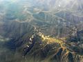 Aerial photo of Mount Buller.

See also
 Australia portal
 Mountains portal


References
- ^ a b "Place Names Search:Mount Buller". Geoscience Australia. Archived from the original on 10 February 2012. Retrieved 8 February 2012.
- ^ "Topographic map of Mount Buller". opentopomap.org. Retrieved 16 April 2023.
- ^ "Mount Buller". Gazetteer of Australia online. Geoscience Australia, Australian Government.
- ^ Blake, Les (1977). Place names of Victoria. Adelaide: Rigby. pp. 182, 50.
- ^ Annual snow days sorted in descending order of average occurrence by australianweathernews.com
- ^ "Mt Buller Daily Summaries". www.weatherzone.com.au. Retrieved 4 February 2023.
- ^ "Climate statistics for Mount Buller". Australian Bureau of Meteorology. Retrieved 24 June 2014.
External links
 Media related to Mount Buller at Wikimedia Commons
- "Mount Buller, Skiing Snowboarding and Snow Holidays". MtBuller. Archived from the original on 4 March 2010. Retrieved 3 March 2010.
- "Be on the top of the world". Mount Buller Official Website. Retrieved 3 March 2010.
- v
- t
- e
- William (1,167 m or 3,829 ft)
- Difficult
- Wilson
- Zero (364 m or 1,194 ft)
| Bogong High Plains |
|
|---|---|
| Cathedral Range |
|
| Cobberas Range |
|
| Cobbler Plateau |
|
| Other |
|
mountain ranges
| Central Highlands |
|
|---|---|
| Dandenong Ranges |
|
| Pyrenees Ranges |
|
| Strzelecki Ranges |
|
| Other |
|
| Authority control databases |
|
|---|


