Mount Niles
Mountain in Yoho NP, BC, Canada


Mount Niles
Location of Mount Niles in British Columbia
Show map of British Columbia
Mount Niles
Mount Niles (Canada)
Show map of CanadaBritish Columbia, Canada
Canadian Rockies
Mount Niles is a 2,967-metre (9,734-foot) summit located in the Waputik Range of Yoho National Park, in the Canadian Rockies of British Columbia, Canada. The nearest higher peak is Mount Daly, 1.63 km (1.01 mi) to the immediate northeast.[1] Takakkaw Falls is situated four km to the west, the Waputik Icefield lies to the north, and Sherbrooke Lake lies to the south. Precipitation runoff from Mount Niles drains into the Yoho River and Niles Creek, both tributaries of the Kicking Horse River. Topographic relief is significant as the summit rises approximately 1,500 meters (4,920 feet) above Yoho Valley in four kilometers (2.5 mile).
History
Charles Sproull Thompson (1869–1921) named the peak in 1898, for William H. Niles (1838–1910), president of the Appalachian Mountain Club and Professor of Geology at Massachusetts Institute of Technology who also did some mountaineering in the area.[5] [6]
The first ascent of the mountain was made in 1898 by D. Campbell and Charles E. Fay.[5]
The mountain's toponym was officially adopted in 1924 by the Geographical Names Board of Canada.[3]
Geology
Mount Niles is composed of sedimentary rock laid down during the Precambrian to Jurassic periods.[7] Formed in shallow seas, this sedimentary rock was pushed east and over the top of younger rock during the Laramide orogeny.[8]
Climate
Based on the Köppen climate classification, Mount Niles is located in a subarctic climate zone with cold, snowy winters, and mild summers.[9] Winter temperatures can drop below −20 °C with wind chill factors below −30 °C.
Gallery
-
 Mount Niles' south aspect seen from Sherbrooke Lake
 -
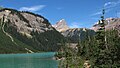 Mount Niles (centered in the distance) seen from Sherbrooke Lake
 -
 Mount Niles right of center with Mount Daly and Daly Glacier to left, and Takakkaw Falls in lower right, as seen from Iceline Trail


See also
 Mountains portal

References
- ^ a b c "Mount Niles, British Columbia". Peakbagger.com. Retrieved 2019-09-21.
- ^ a b "Mount Niles". Bivouac.com. Retrieved 2019-03-20.
- ^ a b c "Mount Niles". Geographical Names Data Base. Natural Resources Canada. Retrieved 2019-03-20.
- ^ Kane, Alan (1999). "Mount Niles". Scrambles in the Canadian Rockies. Calgary: Rocky Mountain Books. pp. 274–275. ISBN 0-921102-67-4.
- ^ a b "Mount Niles". cdnrockiesdatabases.ca. Retrieved 2019-09-21.
- ^ Canadian Mountain Place Names - The Rockies and Columbia Mountains, Glen W. Boles, Roger W. Laurilla, William L. Putnam, Rocky Mountain Books, 2006, page 183.
- ^ Belyea, Helen R. (1960). The Story of the Mountains in Banff National Park (PDF). parkscanadahistory.com (Report). Ottawa: Geological Survey of Canada. Archived (PDF) from the original on 2015-10-02. Retrieved 2019-09-13.
- ^ Gadd, Ben (2008). Geology of the Rocky Mountains and Columbias.
- ^ Peel, M. C.; Finlayson, B. L.; McMahon, T. A. (2007). "Updated world map of the Köppen−Geiger climate classification". Hydrol. Earth Syst. Sci. 11: 1633–1644. ISSN 1027-5606.
External links
- Weather: Mount Niles
- Parks Canada web site: Yoho National Park
- "Mount Niles". BC Geographical Names.
- v
- t
- e
Places adjacent to Mount Niles
| Daly Glacier | Waputik Icefield | Mount Daly |
 | ||
| Takakkaw Falls |  Mount Niles Mount Niles | Continental Divide |
| Yoho River |  | |
| Wapta Mountain | Mount Ogden | Mount Bosworth |


