Mua District
District in Wallis and Futuna, France
Mua Mu'a | |
|---|---|
District | |
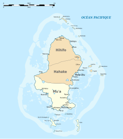 Map of Wallis Island showing the 3 districts: Mua is located in the South | |
| Coordinates: 13°20′25″S 176°11′30″W / 13.34028°S 176.19167°W / -13.34028; -176.19167 | |
| Country |  France France |
| Territory |  Wallis and Futuna Wallis and Futuna |
| Island | Wallis |
| Chiefdom | Uvea |
| Capital | Mala'efo'ou |
| Area | |
| • Total | 26.3 km2 (10.2 sq mi) |
| Population (2018) | |
| • Total | 2,976 |
| Time zone | UTC+12 |
| No. of municipalities | 10 |
Mua (also spelled Mu'a, Uvean for "first") is one of the 5 districts of Wallis and Futuna, located in Wallis Island, in the Pacific Ocean. It is part of the Chiefdom of Uvea.
Geography
Located in the southern side of the island, Mua borders with the districts of Hahake. Mala'efo'ou (formerly named Mu'a) is the administrative seat.
The district is divided into 10 municipal villages, with the combined population of 2,976.[1]
| Village | Population |
|---|---|
| Utufua | 602 |
| Halalo | 471 |
| Vaimalau | 371 |
| Lavegahau | 330 |
| Teesi | 216 |
| Malaefoou | 171 |
| Gahi | 249 |
| Tepa | 270 |
| Haatofo | 197 |
| Kolopopo | 99 |
See also
References
External links
- "Mua District" (Map). Google Maps. Google. 4 September 2013. Retrieved 4 September 2013.
- v
- t
- e
Wallis and Futuna articles
- Wallis (Uvea)
- Hoorn Islands
- Futuna
- Alofi

and districts


|
- Category


