Nahal Amud
River in Upper Galilee region of Israel
33°0′46.57″N 35°28′2.87″E / 33.0129361°N 35.4674639°E / 33.0129361; 35.4674639 • location
• coordinates
• elevation
Nahal Amud (Hebrew: נַחַל עַמּוּד), also known as the Wadi al-Amud, is a stream in the Upper Galilee region of Israel that flows into the Sea of Galilee.
History

The source of the stream, Ramat Dalton, is located 800 meters above sea level. Its drainage basin includes the peaks of Mount Canaan (955 meters) and Mount Meron (1,204 meters) and flows south through eastern Galilee to the northwest part of the Sea of Galilee – a height of less than 200 meters below sea level.
The stream is named after a pillar that rises high above ground and is located near a channel of the stream near Kibbutz Hukok. The gorge that forms the channel at this point holds many caves once inhabited by Homo heidelbergensis and later by Neanderthal Man such as the cave at Zuttiyeh and the Amud cave. They were the object of the first paleoanthropological excavations in Mandatory Palestine in 1925–1926.[1] The caves contained hominin remains as well as Mousterian and Acheulean artifacts.
Most of Nahal Amud (8923 dunams) was declared a nature reserve in 1972.[2]
Tributaries
The tributaries of the stream:
The drainage basin of the stream is bordered by the Korazim Stream and the Zalmon Stream.
Gallery
-
 Looking north from Nahal Amud lookout
 -
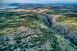 Looking south from Nahal Amud lookout
 -
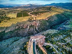 Water flows from the open Canal of the National Water Carrier of Israel into the inverted siphon in Nahal Amud and to the open canal on the other side
 -
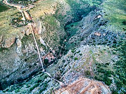 The inverted siphon in Nahal Amud


See also
References
External links
Wikimedia Commons has media related to Nahal Amud.
- Amud stream @ eretz.com
- v
- t
- e
Streams of the Galilee
- Nahal Amud
- Nahal Akbara
- Nahal Aviv
- Nahal Gush Halav
- Nahal Dishon
- Nahal Hatzor
- Nahal Yir'on
- Nahal Moran
- Nahal Mahanaim
- Nahal Meron
- Nahal Neria
- Nahal Tziv'on
- Nahal Rosh Pina
- Nahal Rabbi Yannai
- Nahal Pashhur
- Nahal Seter
- Nahal Hanania
- Nahal Livnim
- Nahal Hozim
- Nahal Sekhwi
- Nahal Shamai
- Nahal Hukok
- Nahal Razim
- Nahal Etsbonit
- Nahal Halav
- Nahal Almon
- Nahal Ketzion
- Nahal Bar'am
- Nahal Ben Zimra
- Nahal Marot
- Nahal Parod
- Nahal Ofa'im
- Nahal Peki'in
- Nahal Zeved
- Nahal Zavit
- Nahal Baratot
- Nahal Hiram
- Nahal Admonit
- Nahal Shfan
- Nahal Zoch
- Nahal Itzhar
- Nahal Azehav
- Nahal Dalton
- Nahal Sod
- Nahal Bar Yohai
- Nahal Birnit
- Nahal Mishmesh
- Nahal Mattat
- Nahal Serakh
- Nahal Betzet
- Nahal Hanita
- Nahal Nammer
- Nahal Galil
- Nahal Matzuba
- Nahal Sha'al
- Nahal Eshhar
- Nahal Nahet
- Nahal Yassaf
- Nahal Kziv
- Nahal Meirav
- Nahal Meirav
- Nahal Oshrat
- Nahal Ga'aton
- Nahal Birya
- Nahal Abalim
- Nahal Adami
- Nahal Arbel
- Nahal Gdora
- Nahal Dana
- Nahal Hashiv'a
- Nahal Hilazon
- Nahal Harod
- Nahal Yavne'el
- Nahal Yama
- Nahal Yissakhar
- Nahal Kavul
- Nahal Nahalal
- Nahal Nun
- Nahal Tzipori
- Nahal Zalmon
- Nahal Shunem
- Nahal Shizafim
- Nahal Shekhanya
- Nahal Sarona
- Nahal Tavor
- Nahal Kankan
- Nahal Kamon
- Nahal Hazon
- Nahal Sheva
- Nahal Ha'ari
- Nahal Memlakh
- Nahal Oznit
- Nahal Saviona
- Nahal Namerim
- Nahal Mazga
- Nahal Akav
- Nahal Hamud
- Nahal Aznat
- Nahal Keshet
- Wadi al-Hussain
- Nahal Morsan
- Nahal Na'iel
- Nahal Sakhnin
- Nahal Segev
- Nahal Tamra
- Nahal Hanina
- Nahal Zuf
- Nahal Abid
- Nahal Hanna
- Nahal Shazur
- Nahal Yiftah'el
- Nahal Sargona
- Nahal Zoreim
- Nahal Shovav
- Nahal Poria
- Nahal Hartsit
- Nahal Tzideta
- Nahal Alot
- Nahal Berit
- Nahal Tola
- Nahal Yahmi
- Nahal Gvul
- Nahal Tzva'im
- Nahal Zika
- Nahal Geva
- Nahal Na'ura
- Nahal Akin
- Nahal Rakhash
- Nahal Kokhav
- Nahal Salil
- Nahal HaKosmet
- Nahal Okhel
- Nahal Kish
- Nahal Yazir
- Nahal Barak ben Avinoam
- Nahal Kamma
- Nahal Hamud
- Nahal Ein Dor
- Nahal Dvora
- Nahal Shomer
- Nahal Dan
- Nahal Snir
- Nahal Hermon
- Nahal Ayun
- Nahal Kedesh
- Nahal Misgav
- Nahal HaShomer
- Nahal Margaliot
- Nahal Koren
- Nahal Serakh
- Nahal Betzet
- Nahal Ga'aton
- Nahal Yehi'am
- Nahal Sha'al
- Nahal Yassaf
- Nahal Kziv
Authority control databases | |
|---|---|
| International |
|
| National |
|
32°52′51.31″N 35°30′11.75″E / 32.8809194°N 35.5032639°E / 32.8809194; 35.5032639
This article related to a river in Israel is a stub. You can help Wikipedia by expanding it. |
- v
- t
- e
 | This article relating to anthropology is a stub. You can help Wikipedia by expanding it. |
- v
- t
- e
 | This paleontological site article is a stub. You can help Wikipedia by expanding it. |
- v
- t
- e


