National Register of Historic Places listings in Benton County, Iowa
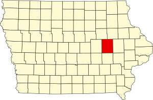
This is a list of the National Register of Historic Places listings in Benton County, Iowa.
This is intended to be a complete list of the properties and districts on the National Register of Historic Places in Benton County, Iowa, United States. Latitude and longitude coordinates are provided for many National Register properties and districts; these locations may be seen together in a map.[1]
There are 16 properties listed on the National Register in the county, and one former listing.
This National Park Service list is complete through NPS recent listings posted August 16, 2024.[2]
Map all coordinates using OpenStreetMap
Download coordinates as:
- KML
- GPX (all coordinates)
- GPX (primary coordinates)
- GPX (secondary coordinates)
| [3] | Name on the Register[4] | Image | Date listed[5] | Location | City or town | Description |
|---|---|---|---|---|---|---|
| 1 | Belle Plaine Main Street Historic District |  | October 16, 2013 (#13000828) | Roughly bounded by 7th & 9th Avenues and 11th & 13th Streets 41°53′47″N 92°16′36″W / 41.896332°N 92.276557°W / 41.896332; -92.276557 (Belle Plaine Main Street Historic District) | Belle Plaine | |
| 2 | Benton County Courthouse |  | October 8, 1976 (#76000733) | E. 4th St. 42°10′05″N 92°01′25″W / 42.168056°N 92.023611°W / 42.168056; -92.023611 (Benton County Courthouse) | Vinton | Beaux Arts Renaissance classicism style 1905 County Courthouse.[6] |
| 3 | Burlington, Cedar Rapids & Northern Passenger Station-Vinton | 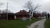 | December 6, 1990 (#90001852) | 612 2nd Ave. 42°09′55″N 92°01′19″W / 42.165278°N 92.021944°W / 42.165278; -92.021944 (Burlington, Cedar Rapids & Northern Passenger Station-Vinton) | Vinton | 1900 stone and brick depot with marble floor tiles and oak wood work. Within 3 years, became a part of the Rock Island line, also known as the Chicago, Rock Island and Pacific Railroad.[7] |
| 4 | Central Vinton Residential Historic District |  | November 21, 2012 (#12000948) | Roughly bounded by 2nd & D Aves., W. 13th & W. 6th Sts. 42°09′45″N 92°01′34″W / 42.16246°N 92.0262°W / 42.16246; -92.0262 (Central Vinton Residential Historic District) | Vinton | Historic residential district representing the largest intact collection of contiguous mid-nineteenth to mid-twentieth century dwellings in Vinton. Most dwellings have not been significantly altered. The district also contains three churches built prior to 1955 which are included as contributing for their architectural significance.[8] |
| 5 | Herring Hotel | 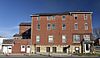 | December 31, 2008 (#08001250) | 718 13th St. 41°53′49″N 92°16′35″W / 41.89705°N 92.27636°W / 41.89705; -92.27636 (Herring Hotel) | Belle Plaine | Built in 1900, this once prominent hotel was a version of the so-called "one-stop" along the Lincoln Highway where travelers could find lodging, food, entertainment, and service for their cars.[9] |
| 6 | Iowa Canning Company Seed House Building | 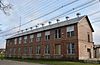 | March 12, 2012 (#12000094) | 201 1st Ave. 42°10′10″N 92°01′29″W / 42.169336°N 92.024728°W / 42.169336; -92.024728 (Iowa Canning Company Seed House Building) | Vinton | |
| 7 | James Greer McQuilkin Round Barn | Upload image | June 30, 1986 (#86001414) | Off County Road D65 42°16′06″N 92°16′49″W / 42.268306°N 92.280403°W / 42.268306; -92.280403 (James Greer McQuilkin Round Barn) | Bruce Township | Clay tile exterior round barn, classified as an Iowa Agricultural Experiment Station.[10] |
| 8 | Preston’s Station Historic District |  | September 21, 2020 (#100005572) | 402 4th Ave. 41°53′14″N 92°16′59″W / 41.887291°N 92.282957°W / 41.887291; -92.282957 (Preston’s Station Historic District) | Belle Plaine | |
| 9 | Frank G. Ray House & Carriage House |  | December 10, 1982 (#82000403) | 912 1st Ave. 42°09′44″N 92°01′26″W / 42.162222°N 92.023889°W / 42.162222; -92.023889 (Frank G. Ray House & Carriage House) | Vinton | Late Victorian Queen Anne style home, built for the secretary of the Iowa Canning Company, Frank G. Ray. Property is also known as Ray Towers.[11] |
| 10 | Round Barn, Bruce Township Section 3 | Upload image | June 30, 1986 (#86001415) | County Road D56 42°17′31″N 92°14′08″W / 42.291944°N 92.235556°W / 42.291944; -92.235556 (Round Barn, Bruce Township Section 3) | Bruce Township | |
| 11 | Sankot Motor Company |  | July 28, 1995 (#95000558) | 807 13th St. 41°53′49″N 92°16′32″W / 41.896944°N 92.275556°W / 41.896944; -92.275556 (Sankot Motor Company) | Belle Plaine | |
| 12 | Shellsburg Bridge | Upload image | June 25, 1998 (#98000770) | Pearl St. over Bear Creek 42°05′36″N 91°52′10″W / 42.09342°N 91.86948°W / 42.09342; -91.86948 (Shellsburg Bridge) | Shellsburg | |
| 13 | Upper Stone Schoolhouse | Upload image | July 7, 1983 (#83000340) | East of Vinton 42°10′28″N 91°53′29″W / 42.174444°N 91.891389°W / 42.174444; -91.891389 (Upper Stone Schoolhouse) | Vinton | |
| 14 | Vinton Public Library |  | May 23, 1983 (#83000341) | 510 2nd Ave. 42°09′58″N 92°01′20″W / 42.166111°N 92.022222°W / 42.166111; -92.022222 (Vinton Public Library) | Vinton | |
| 15 | Youngville Cafe | 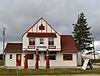 | February 1, 2007 (#06001321) | 2409 73rd St. 41°57′57″N 92°01′32″W / 41.965833°N 92.025556°W / 41.965833; -92.025556 (Youngville Cafe) | Watkins | |
| 16 | Frank E. and Katie (Cherveny) Zalesky House | 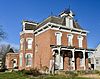 | April 10, 2012 (#12000191) | 802 9th Ave. 41°53′33″N 92°16′31″W / 41.892414°N 92.275309°W / 41.892414; -92.275309 (Frank E. and Katie (Cherveny) Zalesky House) | Belle Plaine |
Former listings
| [3] | Name on the Register | Image | Date listed | Date removed | Location | City or town | Description |
|---|---|---|---|---|---|---|---|
| 1 | Round Barn, Bruce Township Section 6 | Upload image | June 30, 1986 (#86001416) | May 28, 2019 | West of U.S. Route 218 42°17′13″N 92°16′50″W / 42.286944°N 92.280556°W / 42.286944; -92.280556 (Round Barn, Bruce Township Section 6) | Bruce Township |
See also
Wikimedia Commons has media related to National Register of Historic Places in Benton County, Iowa.
- List of National Historic Landmarks in Iowa
- National Register of Historic Places listings in Iowa
- Listings in neighboring counties: Black Hawk, Buchanan, Iowa, Linn, Tama
References
- ^ The latitude and longitude information provided in this table was derived originally from the National Register Information System, which has been found to be fairly accurate for about 99% of listings. Some locations in this table may have been corrected to current GPS standards.
- ^ National Park Service, United States Department of the Interior, "National Register of Historic Places: Weekly List Actions", retrieved August 16, 2024.
- ^ a b Numbers represent an alphabetical ordering by significant words. Various colorings, defined here, differentiate National Historic Landmarks and historic districts from other NRHP buildings, structures, sites or objects.
- ^ "National Register Information System". National Register of Historic Places. National Park Service. April 24, 2008.
- ^ The eight-digit number below each date is the number assigned to each location in the National Register Information System database, which can be viewed by clicking the number.
- ^ Strawn, Olive. "National Register of Historic Places Inventory – Nomination Form: Benton County Courthouse". National Park Service. Retrieved 6 October 2015.
- ^ Holzworth, Richard O. "National Register of Historic Places Inventory – Nomination Form: Burlington, Cedar Rapids & Northern Passenger Station--Vinton". National Park Service. Retrieved 6 October 2015.
- ^ Thomason, Philip. "National Register of Historic Places Inventory – Nomination Form: Central Vinton Residential Historic District". National Park Service. Retrieved 6 October 2015.
- ^ Rogers, Leah. "National Register of Historic Places Inventory – Nomination Form: Herring Hotel". National Park Service. Retrieved 6 October 2015.
- ^ McQuilkin, Kirk M. "National Register of Historic Places Inventory – Nomination Form: McQuilkin, James Greer, Round Barn". National Park Service. Retrieved 7 October 2015.
- ^ Jacobsenorganization, James. "National Register of Historic Places Inventory – Nomination Form: Ray, Frank G., House & Carriage House". National Park Service. Retrieved 7 October 2015.
- v
- t
- e
- List of U.S. National Historic Landmarks by state:
- Alabama
- Alaska
- Arizona
- Arkansas
- California
- Colorado
- Connecticut
- Delaware
- Florida
- Georgia
- Hawaii
- Idaho
- Illinois
- Indiana
- Iowa
- Kansas
- Kentucky
- Louisiana
- Maine
- Maryland
- Massachusetts
- Michigan
- Minnesota
- Mississippi
- Missouri
- Montana
- Nebraska
- Nevada
- New Hampshire
- New Jersey
- New Mexico
- New York
- North Carolina
- North Dakota
- Ohio
- Oklahoma
- Oregon
- Pennsylvania
- Rhode Island
- South Carolina
- South Dakota
- Tennessee
- Texas
- Utah
- Vermont
- Virginia
- Washington
- West Virginia
- Wisconsin
- Wyoming
 National Register of Historic Places portal
 Category


