National Register of Historic Places listings in Clay County, Arkansas

This is a list of the National Register of Historic Places listings in Clay County, Arkansas.
This is intended to be a complete list of the properties and districts on the National Register of Historic Places in Clay County, Arkansas, United States. The locations of National Register properties and districts for which the latitude and longitude coordinates are included below, may be seen in a map.[1]
There are 19 properties and districts listed on the National Register in the county, and one former listing.
This National Park Service list is complete through NPS recent listings posted September 13, 2024.[2]
Map all coordinates using OpenStreetMap
Download coordinates as:
- KML
- GPX (all coordinates)
- GPX (primary coordinates)
- GPX (secondary coordinates)
Current listings
| [3] | Name on the Register[4] | Image | Date listed[5] | Location | City or town | Description |
|---|---|---|---|---|---|---|
| 1 | Baynham House | 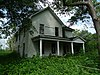 | August 31, 1978 (#78000579) | Stephens St. 36°27′05″N 90°43′29″W / 36.451389°N 90.724722°W / 36.451389; -90.724722 (Baynham House) | Success | Structure no longer exists, 9/2020 |
| 2 | Chalk Bluff |  | October 29, 1974 (#74000470) | North of St. Francis 36°28′41″N 90°09′32″W / 36.478056°N 90.158889°W / 36.478056; -90.158889 (Chalk Bluff) | St. Francis | |
| 3 | Clay County Courthouse, Eastern District |  | September 19, 2018 (#100002945) | 151 S 2nd Ave. 36°22′56″N 90°11′32″W / 36.3822°N 90.1922°W / 36.3822; -90.1922 (Clay County Courthouse, Eastern District) | Piggott | |
| 4 | Clay County Courthouse, Western District | 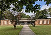 | September 18, 2018 (#100002946) | 800 W 2nd St. 36°24′15″N 90°35′04″W / 36.4042°N 90.5844°W / 36.4042; -90.5844 (Clay County Courthouse, Western District) | Corning | |
| 5 | County Home Cemetery |  | March 22, 2005 (#04001495) | 3010 Heritage Park Rd. 36°23′11″N 90°12′39″W / 36.386389°N 90.210833°W / 36.386389; -90.210833 (County Home Cemetery) | Piggott | |
| 6 | Eastern Star Lodge 207 F&AM |  | October 4, 2002 (#02001074) | Approximately 1.5 miles west on County Road 336, then 0.5 miles south Cty Rte. 347 36°27′05″N 90°10′31″W / 36.451389°N 90.175278°W / 36.451389; -90.175278 (Eastern Star Lodge 207 F&AM) | St. Francis | |
| 7 | Knob School-Masonic Lodge | 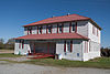 | May 30, 1991 (#91000679) | Highway 141 36°16′53″N 90°27′00″W / 36.281389°N 90.45°W / 36.281389; -90.45 (Knob School-Masonic Lodge) | Knob | |
| 8 | Old US 67, Biggers to Datto |  | September 24, 2004 (#04001046) | Biggers-Reyno Rd., 1st St., and County Road 111 36°21′35″N 90°46′37″W / 36.359722°N 90.776944°W / 36.359722; -90.776944 (Old US 67, Biggers to Datto) | Datto | Extends into Randolph County |
| 9 | Oliver House | 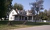 | December 8, 1978 (#78000578) | 203 W. Front St. 36°24′35″N 90°34′44″W / 36.409722°N 90.578889°W / 36.409722; -90.578889 (Oliver House) | Corning | |
| 10 | Pfeiffer House and Carriage House | 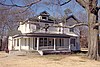 | June 10, 1982 (#82002097) | 10th and Cherry Sts. 36°23′04″N 90°12′00″W / 36.384444°N 90.2°W / 36.384444; -90.2 (Pfeiffer House and Carriage House) | Piggott | |
| 11 | Piggott Commercial Historic District |  | November 4, 2009 (#09000867) | Roughly bounded on the north by W. Cherry, on the south by W. Court, on the east by S. Throckmorton, and on the west by Clay 36°22′58″N 90°11′26″W / 36.382839°N 90.190656°W / 36.382839; -90.190656 (Piggott Commercial Historic District) | Piggott | |
| 12 | Piggott National Guard Armory | 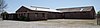 | May 31, 2006 (#06000440) | 775 E. Main St. 36°22′59″N 90°10′53″W / 36.383056°N 90.181389°W / 36.383056; -90.181389 (Piggott National Guard Armory) | Piggott | |
| 13 | Piggott Post Office | 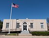 | August 14, 1998 (#98000917) | 119 N. 3rd St. 36°23′00″N 90°11′33″W / 36.383333°N 90.1925°W / 36.383333; -90.1925 (Piggott Post Office) | Piggott | |
| 14 | Rector Commercial Historic District | 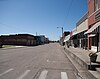 | June 1, 2009 (#09000369) | Bounded by the former St. Louis Southwestern Railway railroad tracks on the east and south, S. Dodd on the west, and 3rd St. on the north 36°15′49″N 90°17′34″W / 36.263686°N 90.292717°W / 36.263686; -90.292717 (Rector Commercial Historic District) | Rector | |
| 15 | Rector Waterworks Building |  | May 12, 2009 (#09000312) | 703 S. Main St. 36°15′39″N 90°17′34″W / 36.26075°N 90.292722°W / 36.26075; -90.292722 (Rector Waterworks Building) | Rector | |
| 16 | Scatterville Cemetery |  | March 31, 1995 (#95000364) | County Road 404, 1.5 miles west of Highway 90 36°16′55″N 90°18′47″W / 36.281944°N 90.313056°W / 36.281944; -90.313056 (Scatterville Cemetery) | Rector | |
| 17 | Sheeks House | 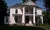 | August 22, 1975 (#75000376) | 502 Market St. 36°24′18″N 90°35′02″W / 36.405°N 90.583889°W / 36.405; -90.583889 (Sheeks House) | Corning | |
| 18 | Sink-Crumb Post No. 72 American Legion Hut | 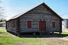 | September 25, 2008 (#08000934) | Northeastern corner of the junction of 2nd and Cherry Sts. 36°19′13″N 90°36′01″W / 36.320308°N 90.600222°W / 36.320308; -90.600222 (Sink-Crumb Post No. 72 American Legion Hut) | Knobel | |
| 19 | Waddle House | Upload image | March 28, 1977 (#77000246) | S. Erwin 36°27′04″N 90°43′21″W / 36.451111°N 90.7225°W / 36.451111; -90.7225 (Waddle House) | Success | Structure no longer exists, 9/2020 |
Former listings
| [3] | Name on the Register | Image | Date listed | Date removed | Location | City or town | Description |
|---|---|---|---|---|---|---|---|
| 1 | Esso Station |  | June 2, 2000 (#00000604) | January 2, 2024 | 287 E Main 36°22′34″N 90°11′16″W / 36.376111°N 90.187778°W / 36.376111; -90.187778 (Esso Station) | Piggott | Demolished sometime after April 2016 |
See also
Wikimedia Commons has media related to National Register of Historic Places in Clay County, Arkansas.
- List of National Historic Landmarks in Arkansas
- National Register of Historic Places listings in Arkansas
References
- ^ The latitude and longitude information provided in this table was derived originally from the National Register Information System, which has been found to be fairly accurate for about 99% of listings. Some locations in this table may have been corrected to current GPS standards.
- ^ National Park Service, United States Department of the Interior, "National Register of Historic Places: Weekly List Actions", retrieved September 13, 2024.
- ^ a b Numbers represent an alphabetical ordering by significant words. Various colorings, defined here, differentiate National Historic Landmarks and historic districts from other NRHP buildings, structures, sites or objects.
- ^ "National Register Information System". National Register of Historic Places. National Park Service. March 13, 2009.
- ^ The eight-digit number below each date is the number assigned to each location in the National Register Information System database, which can be viewed by clicking the number.
- v
- t
- e
- List of U.S. National Historic Landmarks by state:
- Alabama
- Alaska
- Arizona
- Arkansas
- California
- Colorado
- Connecticut
- Delaware
- Florida
- Georgia
- Hawaii
- Idaho
- Illinois
- Indiana
- Iowa
- Kansas
- Kentucky
- Louisiana
- Maine
- Maryland
- Massachusetts
- Michigan
- Minnesota
- Mississippi
- Missouri
- Montana
- Nebraska
- Nevada
- New Hampshire
- New Jersey
- New Mexico
- New York
- North Carolina
- North Dakota
- Ohio
- Oklahoma
- Oregon
- Pennsylvania
- Rhode Island
- South Carolina
- South Dakota
- Tennessee
- Texas
- Utah
- Vermont
- Virginia
- Washington
- West Virginia
- Wisconsin
- Wyoming
 National Register of Historic Places portal
 Category


Municipalities and communities of Clay County, Arkansas, United States | ||
|---|---|---|
County seats: Corning and Piggott | ||
| Cities |  | |
| Towns | ||
| Unincorporated communities | ||
| Ghost town | ||
| Footnotes | ‡This populated place also has portions in an adjacent county or counties | |
| ||


