National Register of Historic Places listings in Hillsborough County, New Hampshire

This is intended to be a complete list of the properties and districts on the National Register of Historic Places in Hillsborough County, New Hampshire, United States. Latitude and longitude coordinates are provided for many National Register properties and districts; these locations may be seen together in a map.[1]
There are 110 properties and districts listed on the National Register in the county, including 2 National Historic Landmarks.
| Belknap - Carroll - Cheshire - Coös - Grafton - Hillsborough - Merrimack - Rockingham - Strafford - Sullivan |
This National Park Service list is complete through NPS recent listings posted September 5, 2024.[2]
Map all coordinates using OpenStreetMap
Download coordinates as:
- KML
- GPX (all coordinates)
- GPX (primary coordinates)
- GPX (secondary coordinates)
Current listings
| [3] | Name on the Register[4] | Image | Date listed[5] | Location | City or town | Description |
|---|---|---|---|---|---|---|
| 1 | Abbot House |  | April 17, 1980 (#80000289) | 1 Abbott Sq. 42°45′57″N 71°28′08″W / 42.7658°N 71.4689°W / 42.7658; -71.4689 (Abbot House) | Nashua | |
| 2 | All Saints' Church |  | December 1, 1980 (#80000290) | 51 Concord St. 42°52′50″N 71°56′48″W / 42.8806°N 71.9467°W / 42.8806; -71.9467 (All Saints' Church) | Peterborough | |
| 3 | Amherst Village Historic District |  | August 18, 1982 (#82001679) | NH 101 and NH 122 42°51′46″N 71°37′37″W / 42.8628°N 71.6269°W / 42.8628; -71.6269 (Amherst Village Historic District) | Amherst | |
| 4 | Ash Street School |  | May 30, 1975 (#75000232) | Bounded by Ash, Bridge, Maple, and Pearl Sts. 42°59′46″N 71°27′17″W / 42.9961°N 71.4547°W / 42.9961; -71.4547 (Ash Street School) | Manchester | |
| 5 | Athens Building | 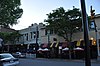 | May 30, 1975 (#75000123) | 76–96 Hanover St. 42°59′29″N 71°27′43″W / 42.9914°N 71.4619°W / 42.9914; -71.4619 (Athens Building) | Manchester | |
| 6 | Jonathan Barnes House |  | March 1, 1982 (#82001680) | North Rd. 43°08′51″N 71°56′02″W / 43.1475°N 71.9339°W / 43.1475; -71.9339 (Jonathan Barnes House) | Hillsborough Center | |
| 7 | Bedford Presbyterian Church |  | June 12, 2007 (#07000554) | 4 Church Rd. 42°56′42″N 71°31′12″W / 42.945°N 71.52°W / 42.945; -71.52 (Bedford Presbyterian Church) | Bedford | |
| 8 | Bedford Town Hall |  | December 13, 1984 (#84000530) | 70 Bedford Center Rd. 42°56′47″N 71°30′57″W / 42.9464°N 71.5158°W / 42.9464; -71.5158 (Bedford Town Hall) | Bedford | |
| 9 | Bennington Village Historic District | 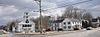 | April 19, 2010 (#10000185) | Antrim Rd, Main St, School St, Cross St, Francestown Rd, South Bennington Rd, Acre St, Old Stagecoach Rd, Starrett Rd. 43°00′11″N 71°55′28″W / 43.0031°N 71.9244°W / 43.0031; -71.9244 (Bennington Village Historic District) | Bennington | |
| 10 | Birchwood Inn | 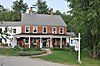 | June 6, 1985 (#85001194) | NH 45 42°49′12″N 71°51′04″W / 42.82°N 71.8511°W / 42.82; -71.8511 (Birchwood Inn) | Temple | |
| 11 | Brick Schoolhouse |  | September 14, 2002 (#02000957) | 432 NH 123 42°48′52″N 71°55′00″W / 42.8144°N 71.9167°W / 42.8144; -71.9167 (Brick Schoolhouse) | Sharon | |
| 12 | Building at 418–420 Notre Dame Ave. |  | December 20, 1996 (#96001467) | 418–420 Notre Dame Ave. 42°59′35″N 71°28′34″W / 42.9931°N 71.4761°W / 42.9931; -71.4761 (Building at 418–420 Notre Dame Ave.) | Manchester | Houses the America's Credit Union Museum, site of the first credit union |
| 13 | Carpenter and Bean Block |  | December 13, 2002 (#02001548) | 1382–1414 Elm St. 42°59′52″N 71°27′53″W / 42.9978°N 71.4647°W / 42.9978; -71.4647 (Carpenter and Bean Block) | Manchester | |
| 14 | Frank Pierce Carpenter House | 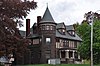 | March 17, 1994 (#94000168) | 1800 Elm St. 43°00′17″N 71°27′57″W / 43.0047°N 71.4658°W / 43.0047; -71.4658 (Frank Pierce Carpenter House) | Manchester | |
| 15 | Amos Chase House and Mill | 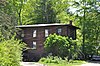 | March 12, 1992 (#92000155) | Western side of NH 114, 1/8 mile south of its junction with NH 77 43°06′32″N 71°45′01″W / 43.1089°N 71.7503°W / 43.1089; -71.7503 (Amos Chase House and Mill) | Weare | |
| 16 | Citizens' Hall |  | December 9, 1999 (#99001482) | 13–12 Citizens' Hall Rd. 42°52′44″N 71°47′05″W / 42.8789°N 71.7847°W / 42.8789; -71.7847 (Citizens' Hall) | Lyndeborough | |
| 17 | Contoocook Mills Industrial District |  | June 10, 1975 (#75000124) | Between Mill St. and the Contoocook River; also Mill St. 43°06′48″N 71°53′40″W / 43.1133°N 71.8944°W / 43.1133; -71.8944 (Contoocook Mills Industrial District) | Hillsborough | Mill St. represents a boundary increase. |
| 18 | County Farm Bridge |  | May 14, 1981 (#81000070) | Northwest of Wilton on Old County Farm Rd. 42°51′25″N 71°49′03″W / 42.8569°N 71.8175°W / 42.8569; -71.8175 (County Farm Bridge) | Wilton | |
| 19 | Daniel Cragin Mill |  | March 23, 1982 (#82001681) | West of Wilton at the junction of Davisville Rd. and the Burton Highway 42°51′22″N 71°47′20″W / 42.8561°N 71.7889°W / 42.8561; -71.7889 (Daniel Cragin Mill) | Wilton | Also known as Frye's Measure Mill |
| 20 | Currier Gallery of Art | 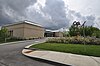 | December 19, 1979 (#79000199) | 192 Orange St. 42°59′52″N 71°27′21″W / 42.9978°N 71.4558°W / 42.9978; -71.4558 (Currier Gallery of Art) | Manchester | |
| 21 | District A | 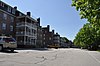 | November 12, 1982 (#82000618) | Bounded by Pleasant, State, Granite, and Bedford Sts. 42°59′14″N 71°28′05″W / 42.9872°N 71.4681°W / 42.9872; -71.4681 (District A) | Manchester | Worker housing district located near the Amoskeag Millyard |
| 22 | District B | 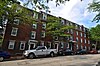 | November 12, 1982 (#82000619) | Roughly bounded by Canal, Mechanic, Franklin, and Pleasant Sts. 42°59′25″N 71°27′57″W / 42.9903°N 71.4658°W / 42.9903; -71.4658 (District B) | Manchester | Worker housing district located near the Amoskeag Millyard |
| 23 | District C |  | November 12, 1982 (#82000620) | Roughly bounded by N. Hampshire Lane, Hollis, Canal, and Bridge Sts. 42°59′43″N 71°27′55″W / 42.9953°N 71.4653°W / 42.9953; -71.4653 (District C) | Manchester | Worker housing district located near the Amoskeag Millyard |
| 24 | District D | 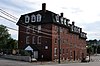 | November 12, 1982 (#82000621) | Roughly bounded by Canal, Langdon, Elm, and W. Brook Sts. 42°59′57″N 71°27′59″W / 42.9992°N 71.4664°W / 42.9992; -71.4664 (District D) | Manchester | Worker housing district located near the Amoskeag Millyard |
| 25 | District E |  | November 12, 1982 (#82000622) | 258–322 McGregor St. 42°59′40″N 71°28′27″W / 42.9944°N 71.4742°W / 42.9944; -71.4742 (District E) | Manchester | Worker housing district located near the Amoskeag Millyard |
| 26 | Dunlap Building |  | June 9, 2004 (#04000587) | 967 Elm St. 42°59′30″N 71°27′48″W / 42.9917°N 71.4633°W / 42.9917; -71.4633 (Dunlap Building) | Manchester | |
| 27 | The Flint Estate | 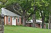 | December 13, 1984 (#84000525) | Old Keene and Old Center Rd. 43°05′04″N 71°58′40″W / 43.0844°N 71.9778°W / 43.0844; -71.9778 (The Flint Estate) | Antrim | |
| 28 | Francestown Meetinghouse |  | June 14, 1999 (#99000667) | NH 136 42°59′14″N 71°48′46″W / 42.9872°N 71.8128°W / 42.9872; -71.8128 (Francestown Meetinghouse) | Francestown | |
| 29 | Francestown Town Hall and Academy and Town Common Historic District | 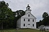 | April 5, 2016 (#16000143) | 2 New Boston Rd. 42°59′13″N 71°48′44″W / 42.987033°N 71.812186°W / 42.987033; -71.812186 (Francestown Town Hall and Academy and Town Common Historic District) | Francestown | |
| 30 | Alpheus Gay House |  | March 9, 1982 (#82001682) | 184 Myrtle St. 42°59′53″N 71°27′25″W / 42.9981°N 71.4569°W / 42.9981; -71.4569 (Alpheus Gay House) | Manchester | |
| 31 | Goffstown Congregational Church |  | March 1, 1996 (#96000193) | 10 Main St. 43°01′10″N 71°36′03″W / 43.0194°N 71.6008°W / 43.0194; -71.6008 (Goffstown Congregational Church) | Goffstown | |
| 32 | Goffstown Covered Railroad Bridge |  | June 18, 1975 (#75000125) | NH 114 (Main St.) over the Piscataquog River 43°01′04″N 71°35′58″W / 43.0178°N 71.5994°W / 43.0178; -71.5994 (Goffstown Covered Railroad Bridge) | Goffstown | Destroyed by fire on August 16, 1976[6] (Bridge abutments are visible in the photo.) |
| 33 | Goffstown High School | 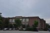 | December 19, 1997 (#97001524) | 12 Reed St. 43°01′10″N 71°35′54″W / 43.0194°N 71.5983°W / 43.0194; -71.5983 (Goffstown High School) | Goffstown | Former high school building is now senior housing. |
| 34 | Goffstown Main Street Historic District | 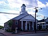 | March 15, 2007 (#07000153) | Selected buildings on Church St., Depot St., High St., Main St., and N. Mast St. 43°01′09″N 71°36′00″W / 43.0191°N 71.5999°W / 43.0191; -71.5999 (Goffstown Main Street Historic District) | Goffstown | |
| 35 | Goffstown Public Library |  | December 7, 1995 (#95001426) | 2 High St. 43°01′14″N 71°36′01″W / 43.0206°N 71.6003°W / 43.0206; -71.6003 (Goffstown Public Library) | Goffstown | |
| 36 | Goodell Company Mill | Upload image | January 6, 2023 (#100008525) | 42 Main St. 43°01′39″N 71°56′16″W / 43.0274°N 71.9378°W / 43.0274; -71.9378 (Goodell Company Mill) | Antrim | |
| 37 | Grasmere Schoolhouse #9 and Town Hall | 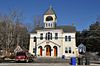 | September 5, 1990 (#90001350) | 87 Center St. 43°01′18″N 71°32′46″W / 43.0217°N 71.5461°W / 43.0217; -71.5461 (Grasmere Schoolhouse #9 and Town Hall) | Goffstown | In village of Grasmere |
| 38 | Greenfield Meeting House | 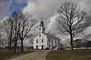 | December 8, 1983 (#83004090) | Forest Rd. 42°57′03″N 71°52′21″W / 42.9508°N 71.8725°W / 42.9508; -71.8725 (Greenfield Meeting House) | Greenfield | |
| 39 | Hamblet-Putnam-Frye House |  | June 22, 2000 (#00000651) | 293 Burton Highway 42°51′23″N 71°47′28″W / 42.8564°N 71.7911°W / 42.8564; -71.7911 (Hamblet-Putnam-Frye House) | Wilton | |
| 40 | Hancock Village Historic District |  | March 8, 1988 (#88000178) | Main St. roughly between Norway Pond La. and Old Dublin Rd., and Bennington and Norway Hill Rds. 42°58′22″N 71°58′59″W / 42.9728°N 71.9831°W / 42.9728; -71.9831 (Hancock Village Historic District) | Hancock | |
| 41 | Hancock–Greenfield Bridge | 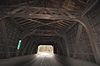 | May 5, 1981 (#81000071) | Forest Rd. 42°57′25″N 71°56′08″W / 42.9569°N 71.9356°W / 42.9569; -71.9356 (Hancock–Greenfield Bridge) | Hancock | Over Contoocook River |
| 42 | Harrington-Smith Block | 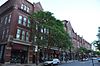 | January 28, 1987 (#86003367) | 18–52 Hanover St. 42°59′28″N 71°27′44″W / 42.9911°N 71.4622°W / 42.9911; -71.4622 (Harrington-Smith Block) | Manchester | |
| 43 | Hill–Lassonde House |  | December 2, 1985 (#85003033) | 269 Hanover St. 42°59′27″N 71°27′21″W / 42.9908°N 71.4558°W / 42.9908; -71.4558 (Hill–Lassonde House) | Manchester | Demolished in 2016.[7] |
| 44 | Hills House |  | April 8, 1983 (#83001141) | 211 Derry Rd. 42°47′46″N 71°26′05″W / 42.7961°N 71.4347°W / 42.7961; -71.4347 (Hills House) | Hudson | Architect Hubert G. Ripley |
| 45 | Hills Memorial Library |  | June 7, 1984 (#84002812) | 16 Library St. 42°45′54″N 71°26′19″W / 42.765°N 71.4386°W / 42.765; -71.4386 (Hills Memorial Library) | Hudson | |
| 46 | Hillsborough County Courthouse | 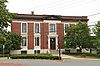 | June 6, 1985 (#85001196) | 19 Temple St. 42°45′41″N 71°27′54″W / 42.7614°N 71.465°W / 42.7614; -71.465 (Hillsborough County Courthouse) | Nashua | |
| 47 | Hillsborough Mills | 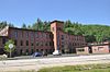 | June 14, 2013 (#13000383) | 37 Wilton Rd. 42°50′28″N 71°43′18″W / 42.8411°N 71.7216°W / 42.8411; -71.7216 (Hillsborough Mills) | Milford | |
| 48 | Hillsborough Railroad Bridge |  | June 10, 1975 (#75000126) | Spans the Contoocook River southwest of NH 149 43°06′48″N 71°53′44″W / 43.1133°N 71.8956°W / 43.1133; -71.8956 (Hillsborough Railroad Bridge) | Hillsborough | Destroyed by arson in 1985.[8] (Image is from a 1907 postcard.) |
| 49 | Hollis Village Historic District |  | March 2, 2001 (#01000204) | Roughly parts of Ash St., Broad St., Cleasby Ln., Depot Rd., Main St., Monument Sq. and Silver Lake Rd. 42°44′17″N 71°35′05″W / 42.7381°N 71.5847°W / 42.7381; -71.5847 (Hollis Village Historic District) | Hollis | |
| 50 | Hoyt Shoe Factory |  | November 7, 1985 (#85002777) | 477 Silver and 170 Lincoln Sts. 42°58′38″N 71°27′05″W / 42.9772°N 71.4514°W / 42.9772; -71.4514 (Hoyt Shoe Factory) | Manchester | |
| 51 | Thomas Russell Hubbard House |  | March 8, 1988 (#88000177) | 220 Myrtle St. 42°59′54″N 71°27′17″W / 42.9983°N 71.4547°W / 42.9983; -71.4547 (Thomas Russell Hubbard House) | Manchester | |
| 52 | Hunt Memorial Library | 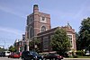 | June 28, 1971 (#71000049) | 6 Main St. 42°45′55″N 71°28′03″W / 42.765152°N 71.467448°W / 42.765152; -71.467448 (Hunt Memorial Library) | Nashua | |
| 53 | Kennedy Hill Farm | 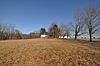 | June 7, 1984 (#84002813) | Kennedy Hill Rd. 42°59′47″N 71°32′21″W / 42.9964°N 71.5392°W / 42.9964; -71.5392 (Kennedy Hill Farm) | Goffstown | |
| 54 | Killicut-Way House | 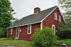 | December 1, 1989 (#89002056) | 2 Old House Ln. 42°43′55″N 71°28′15″W / 42.7319°N 71.4708°W / 42.7319; -71.4708 (Killicut-Way House) | Nashua | |
| 55 | Kimball Brothers Shoe Factory |  | November 7, 1985 (#85002776) | 335 Cypress St. 42°58′55″N 71°26′22″W / 42.9819°N 71.4394°W / 42.9819; -71.4394 (Kimball Brothers Shoe Factory) | Manchester | |
| 56 | Lamson Farm |  | February 24, 1981 (#81000072) | Lamson Rd. 42°55′17″N 71°41′07″W / 42.9214°N 71.6853°W / 42.9214; -71.6853 (Lamson Farm) | Mont Vernon | |
| 57 | Lyndeborough Center Historic District |  | June 7, 1984 (#84002814) | Center Rd. 42°54′24″N 71°46′02″W / 42.9067°N 71.7672°W / 42.9067; -71.7672 (Lyndeborough Center Historic District) | Lyndeborough Center | |
| 58 | MacDowell Colony |  | October 15, 1966 (#66000026) | West of U.S. Route 202 42°53′27″N 71°57′39″W / 42.8908°N 71.9608°W / 42.8908; -71.9608 (MacDowell Colony) | Peterborough | An artists' colony |
| 59 | Manchester City Hall |  | June 13, 1975 (#75000233) | 908 Elm St. 42°59′28″N 71°27′50″W / 42.9911°N 71.4639°W / 42.9911; -71.4639 (Manchester City Hall) | Manchester | |
| 60 | McClure-Hilton House |  | December 1, 1989 (#89002058) | 16 Tinker Rd. 42°48′40″N 71°31′45″W / 42.8111°N 71.5292°W / 42.8111; -71.5292 (McClure-Hilton House) | Merrimack | |
| 61 | The Meetinghouse | 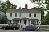 | March 11, 1982 (#82001683) | Monument Sq. 42°44′22″N 71°35′18″W / 42.7394°N 71.5883°W / 42.7394; -71.5883 (The Meetinghouse) | Hollis | |
| 62 | Milford Cotton and Woolen Manufacturing Company |  | August 18, 1982 (#82001684) | 2 Bridge St. 42°50′11″N 71°38′57″W / 42.8364°N 71.6492°W / 42.8364; -71.6492 (Milford Cotton and Woolen Manufacturing Company) | Milford | |
| 63 | Milford Suspension Bridge |  | July 17, 2017 (#100001321) | E. of eastern end of Bridge St. 42°50′12″N 71°38′44″W / 42.836537°N 71.645671°W / 42.836537; -71.645671 (Milford Suspension Bridge) | Milford | |
| 64 | Milford Town House and Library Annex | 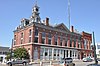 | December 1, 1988 (#88001436) | Nashua St. 42°50′08″N 71°38′58″W / 42.8356°N 71.6494°W / 42.8356; -71.6494 (Milford Town House and Library Annex) | Milford | |
| 65 | Mont Vernon Town Hall |  | May 14, 2024 (#100010318) | 1 South Main Street 42°53′34″N 71°40′26″W / 42.8929°N 71.6738°W / 42.8929; -71.6738 (Mont Vernon Town Hall) | Mont Vernon | |
| 66 | Nashua Gummed and Coated Paper Company Historic District | 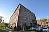 | December 22, 2015 (#15000919) | 34, 44, 55 Franklin & 21, 25 30 Front Sts. 42°45′46″N 71°28′13″W / 42.762729°N 71.470336°W / 42.762729; -71.470336 (Nashua Gummed and Coated Paper Company Historic District) | Nashua | |
| 67 | Nashua Manufacturing Company Historic District | 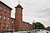 | September 11, 1987 (#87001460) | Factory and Pine Sts. 42°45′35″N 71°28′22″W / 42.7597°N 71.4728°W / 42.7597; -71.4728 (Nashua Manufacturing Company Historic District) | Nashua | |
| 68 | Nashville Historic District | 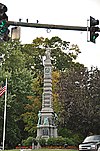 | December 13, 1984 (#84000574) | Roughly centered on junction of Main, Amherst, and Concord Streets 42°46′08″N 71°27′59″W / 42.7689°N 71.4664°W / 42.7689; -71.4664 (Nashville Historic District) | Nashua | |
| 69 | New England Glassworks Site | 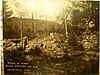 | June 10, 1975 (#75000127) | near Kidder Mountain | Temple | Site of a 1780s glassworks, one of the first in the nation[9] |
| 70 | New Hampshire State Union Armory | 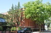 | August 10, 1982 (#82004993) | 60 Pleasant St. 42°59′18″N 71°27′57″W / 42.9883°N 71.4658°W / 42.9883; -71.4658 (New Hampshire State Union Armory) | Manchester | |
| 71 | New Ipswich Center Village Historic District |  | September 3, 1991 (#91001173) | Roughly bounded by Turnpike Rd., Porter Hill Rd., Main St., NH 123A, Preston Hill, Manley, and King Rds. 42°45′10″N 71°51′22″W / 42.7528°N 71.8561°W / 42.7528; -71.8561 (New Ipswich Center Village Historic District) | New Ipswich | |
| 72 | New Ipswich Town Hall | 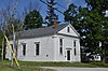 | December 13, 1984 (#84000555) | Main St. 42°44′53″N 71°51′17″W / 42.7481°N 71.8547°W / 42.7481; -71.8547 (New Ipswich Town Hall) | New Ipswich | |
| 73 | Marion Nichols Summer Home |  | December 10, 2003 (#03001283) | 56 Love Lane 42°44′04″N 71°36′02″W / 42.7344°N 71.6006°W / 42.7344; -71.6006 (Marion Nichols Summer Home) | Hollis | Now known as the Beaver Brook Association's Lodge |
| 74 | North Weare Schoolhouse |  | September 6, 1995 (#95001051) | Northern side of Old Concord Stage Rd. east of its junction with NH 114 43°06′40″N 71°44′56″W / 43.1111°N 71.7489°W / 43.1111; -71.7489 (North Weare Schoolhouse) | Weare | |
| 75 | Old County Road South Historic District | 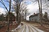 | May 15, 1980 (#80000413) | South of Francestown off NH 136 42°58′27″N 71°48′22″W / 42.9742°N 71.8061°W / 42.9742; -71.8061 (Old County Road South Historic District) | Francestown | |
| 76 | Old Post Office Block | | December 1, 1986 (#86003364) | 54–72 Hanover St. 42°59′28″N 71°27′44″W / 42.9911°N 71.4622°W / 42.9911; -71.4622 (Old Post Office Block) | Manchester | |
| 77 | Parker's Store | 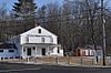 | May 14, 1980 (#80000414) | West of Goffstown on NH 114 43°01′34″N 71°37′42″W / 43.0261°N 71.6283°W / 43.0261; -71.6283 (Parker's Store) | Goffstown | |
| 78 | William Peabody House |  | November 30, 1979 (#79000200) | N. River Rd. 42°50′38″N 71°39′56″W / 42.8439°N 71.6656°W / 42.8439; -71.6656 (William Peabody House) | Milford | |
| 79 | Pelham Library and Memorial Building |  | April 15, 2011 (#11000191) | 5 Main St. 42°44′02″N 71°19′19″W / 42.7339°N 71.3219°W / 42.7339; -71.3219 (Pelham Library and Memorial Building) | Pelham | |
| 80 | Peterborough Town House | 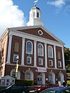 | February 29, 1996 (#96000194) | 1 Grove St. 42°52′38″N 71°57′04″W / 42.8772°N 71.9511°W / 42.8772; -71.9511 (Peterborough Town House) | Peterborough | |
| 81 | Peterborough Unitarian Church | 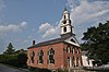 | April 23, 1973 (#73000165) | Main and Summer Sts. 42°52′40″N 71°57′00″W / 42.8778°N 71.95°W / 42.8778; -71.95 (Peterborough Unitarian Church) | Peterborough | |
| 82 | Franklin Pierce Homestead |  | October 15, 1966 (#66000027) | 3 mi (4.8 km) west of Hillsborough on NH 31 43°06′58″N 71°57′03″W / 43.1161°N 71.9508°W / 43.1161; -71.9508 (Franklin Pierce Homestead) | Hillsborough | Childhood home of U.S. President Franklin Pierce |
| 83 | St. George's School and Convent |  | September 12, 1985 (#85002192) | 124 Orange St. 42°59′49″N 71°27′36″W / 42.9969°N 71.46°W / 42.9969; -71.46 (St. George's School and Convent) | Manchester | |
| 84 | Sainte Marie Roman Catholic Church Parish Historic District | 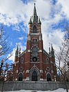 | September 13, 2019 (#100004416) | 378 Notre Dame Ave, 133 Wayne St., 279 & 284 Cartier St. 42°59′32″N 71°28′33″W / 42.9923°N 71.4759°W / 42.9923; -71.4759 (Sainte Marie Roman Catholic Church Parish Historic District) | Manchester | |
| 85 | G.O. Sanders House |  | February 27, 1986 (#86000277) | 10 Derry St. 42°45′57″N 71°26′26″W / 42.7658°N 71.4406°W / 42.7658; -71.4406 (G.O. Sanders House) | Hudson | |
| 86 | Signer's House and Matthew Thornton Cemetery |  | December 22, 1978 (#78000214) | South of Merrimack on U.S. Route 3 42°50′23″N 71°29′30″W / 42.8397°N 71.4917°W / 42.8397; -71.4917 (Signer's House and Matthew Thornton Cemetery) | Merrimack | |
| 87 | Smith and Dow Block | 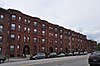 | December 13, 2002 (#02001549) | 1426–1470 Elm St. 42°59′54″N 71°27′54″W / 42.9983°N 71.465°W / 42.9983; -71.465 (Smith and Dow Block) | Manchester | |
| 88 | Gov. John Butler Smith House |  | September 14, 2002 (#02000959) | 62 School St. 43°06′59″N 71°53′47″W / 43.1164°N 71.8964°W / 43.1164; -71.8964 (Gov. John Butler Smith House) | Hillsborough | Houses the local library and town offices |
| 89 | Smyth Tower |  | July 24, 1978 (#78000215) | 718 Smyth Rd. 43°00′44″N 71°26′31″W / 43.0122°N 71.4419°W / 43.0122; -71.4419 (Smyth Tower) | Manchester | On the grounds of the Manchester VA Hospital |
| 90 | Stark Park | 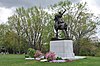 | June 14, 2006 (#06000505) | Bounded by N. River Rd., Park Ave., and the Merrimack River 43°00′52″N 71°28′17″W / 43.0144°N 71.4714°W / 43.0144; -71.4714 (Stark Park) | Manchester | |
| 91 | Gen. George Stark House |  | November 25, 1980 (#80000291) | 22 Concord St. 42°46′05″N 71°28′04″W / 42.7681°N 71.4678°W / 42.7681; -71.4678 (Gen. George Stark House) | Nashua | |
| 92 | Gen. John Stark House |  | June 29, 1973 (#73000166) | 2000 Elm St. 43°00′30″N 71°28′00″W / 43.0083°N 71.4667°W / 43.0083; -71.4667 (Gen. John Stark House) | Manchester | |
| 93 | Stonyfield Farm | 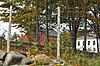 | August 3, 1983 (#83001142) | Northwest of Wilton on Foster Rd. 42°52′00″N 71°47′24″W / 42.8667°N 71.79°W / 42.8667; -71.79 (Stonyfield Farm) | Wilton | Farm (dating to the 19th century) where yogurt-maker Stonyfield Farm was founded |
| 94 | William Parker Straw House | 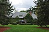 | December 8, 1987 (#87002068) | 282 N. River Rd. 43°00′26″N 71°28′09″W / 43.0072°N 71.4692°W / 43.0072; -71.4692 (William Parker Straw House) | Manchester | |
| 95 | Sullivan House | Upload image | July 6, 2023 (#100009112) | 1330 Union St. 43°01′16″N 71°27′45″W / 43.0211°N 71.4624°W / 43.0211; -71.4624 (Sullivan House) | Manchester | |
| 96 | Roger Sullivan House | 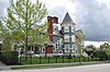 | March 10, 2004 (#04000150) | 168 Walnut St. 42°59′54″N 71°27′30″W / 42.9983°N 71.4583°W / 42.9983; -71.4583 (Roger Sullivan House) | Manchester | |
| 97 | Temple Town Hall | 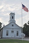 | June 12, 2007 (#07000551) | Main St., junction of NH 45 and the Gen. Miller Highway 42°49′12″N 71°51′08″W / 42.82°N 71.8522°W / 42.82; -71.8522 (Temple Town Hall) | Temple | |
| 98 | Union Chapel | 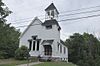 | February 3, 2009 (#08001411) | 220 Sawmill Rd. 43°06′46″N 71°56′37″W / 43.1128°N 71.9437°W / 43.1128; -71.9437 (Union Chapel) | Hillsborough | |
| 99 | US Post Office-Peterborough Main |  | July 17, 1986 (#86002253) | 23 Grove St. 42°52′36″N 71°57′04″W / 42.8767°N 71.9511°W / 42.8767; -71.9511 (US Post Office-Peterborough Main) | Peterborough | |
| 100 | Valley Cemetery | 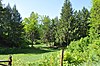 | September 10, 2004 (#04000964) | Pine and Auburn Sts. 42°58′59″N 71°27′40″W / 42.9831°N 71.4611°W / 42.9831; -71.4611 (Valley Cemetery) | Manchester | |
| 101 | Varney School |  | January 11, 1982 (#82001685) | 84 Varney St. 42°58′49″N 71°28′43″W / 42.9803°N 71.4786°W / 42.9803; -71.4786 (Varney School) | Manchester | |
| 102 | Victory Park Historic District |  | June 3, 1996 (#96000615) | 405 Pine, 148 Concord, and 111 and 129 Amherst Sts. 42°59′32″N 71°27′37″W / 42.9922°N 71.4603°W / 42.9922; -71.4603 (Victory Park Historic District) | Manchester | |
| 103 | Weare Town House | 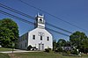 | December 2, 1985 (#85003034) | NH 114 43°05′45″N 71°43′51″W / 43.0958°N 71.7308°W / 43.0958; -71.7308 (Weare Town House) | Weare | |
| 104 | Weston Observatory |  | May 28, 1975 (#75000128) | Oak Hill, Derryfield Park 43°00′04″N 71°26′21″W / 43.0011°N 71.4392°W / 43.0011; -71.4392 (Weston Observatory) | Manchester | |
| 105 | Oliver Whiting Homestead |  | March 9, 1982 (#82001686) | Old County Farm Rd. 42°51′18″N 71°49′21″W / 42.855°N 71.8225°W / 42.855; -71.8225 (Oliver Whiting Homestead) | Wilton | |
| 106 | Caleb Whittaker Place | 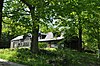 | August 3, 1983 (#83001143) | Perkins Pond Rd. 43°02′46″N 71°44′29″W / 43.0461°N 71.7414°W / 43.0461; -71.7414 (Caleb Whittaker Place) | Weare | |
| 107 | Wilton Public and Gregg Free Library |  | January 11, 1982 (#82001687) | Forest St. 42°50′43″N 71°44′20″W / 42.8453°N 71.7389°W / 42.8453; -71.7389 (Wilton Public and Gregg Free Library) | Wilton | |
| 108 | Wilton Town Hall | 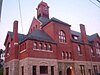 | April 20, 2009 (#09000254) | 42 Main St. 42°50′37″N 71°44′15″W / 42.8435°N 71.7376°W / 42.8435; -71.7376 (Wilton Town Hall) | Wilton | |
| 109 | Levi Woodbury Homestead | 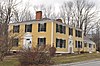 | March 15, 2007 (#07000152) | 1 Main St. 42°59′14″N 71°48′48″W / 42.9872°N 71.8133°W / 42.9872; -71.8133 (Levi Woodbury Homestead) | Francestown | |
| 110 | Zimmerman House | 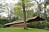 | October 18, 1979 (#79003790) | 223 Heather St. 43°01′18″N 71°27′47″W / 43.0217°N 71.4631°W / 43.0217; -71.4631 (Zimmerman House) | Manchester | House designed by Frank Lloyd Wright; tours operated by the Currier Museum of Art. |
Former listing
| [3] | Name on the Register | Image | Date listed | Date removed | Location | City or town | Description |
|---|---|---|---|---|---|---|---|
| 1 | T. L. Thorpe Building | 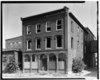 | August 10, 1982 (#82004896) | April 7, 1983 | 19 Traction St. 42°59′13″N 71°27′50″W / 42.986972°N 71.463938°W / 42.986972; -71.463938 (T. L. Thorpe Building) | Manchester | Demolished in 1982 as part of Granite Street redevelopment project. |
See also
Wikimedia Commons has media related to National Register of Historic Places in Hillsborough County, New Hampshire.
- List of National Historic Landmarks in New Hampshire
- National Register of Historic Places listings in New Hampshire
References
- ^ The latitude and longitude information provided in this table was derived originally from the National Register Information System, which has been found to be fairly accurate for about 99% of listings. Some locations in this table may have been corrected to current GPS standards.
- ^ National Park Service, United States Department of the Interior, "National Register of Historic Places: Weekly List Actions", retrieved September 5, 2024.
- ^ a b Numbers represent an alphabetical ordering by significant words. Various colorings, defined here, differentiate National Historic Landmarks and historic districts from other NRHP buildings, structures, sites or objects.
- ^ "National Register Information System". National Register of Historic Places. National Park Service. April 24, 2008.
- ^ The eight-digit number below each date is the number assigned to each location in the National Register Information System database, which can be viewed by clicking the number.
- ^ "Fire of suspicious origin destroys covered bridge". Nashua Telegraph. August 17, 1976.
- ^ Hayward, Mark (July 6, 2016). "Historical Manchester mansion demolished". New Hampshire Union Leader. Retrieved July 7, 2016.
- ^ "Hillsborough, NH: 2004 Draft Master Plan" (PDF). Town of Hillsborough. Archived from the original (PDF) on 2014-05-24. Retrieved 2012-08-16.
- ^ Starbuck, p. 162
- Starbuck, David (2006). The Archeology of New Hampshire. Durham, NH: University of New Hampshire Press. ISBN 9781584655626.
- v
- t
- e
- Franklin Pierce Homestead
- MacDowell Colony

- Amherst Village Historic District
- Bennington Village Historic District
- Contoocook Mills Industrial District
- District A
- District B
- District C
- District D
- District E
- The Flint Estate
- Francestown Town Hall and Academy and Town Common Historic District
- Goffstown Main Street Historic District
- Hancock Village Historic District
- Hollis Village Historic District
- Lyndeborough Center Historic District
- Nashua Gummed and Coated Paper Company Historic District
- Nashua Manufacturing Company Historic District
- Nashville Historic District
- New Ipswich Center Village Historic District
- Old County Road South Historic District
- Sainte Marie Roman Catholic Church Parish Historic District
- Victory Park Historic District
† This entry has been removed from the registry.
See also: National Register of Historic Places listings in Hillsborough County, New Hampshire and List of National Historic Landmarks in New Hampshire
| ||
|---|---|---|
| Topics |  | |
| Lists by county | ||
| Other lists | ||
| ||


Municipalities and communities of Hillsborough County, New Hampshire, United States | ||
|---|---|---|
County seats: Manchester and Nashua | ||
| Cities |  | |
| Towns | ||
| CDPs |
| |
| Other villages | ||
| ||


