National Register of Historic Places listings in Laurens County, Georgia

This is a list of properties and districts in Laurens County, Georgia that are listed on the National Register of Historic Places (NRHP).
Map all coordinates using OpenStreetMap
Download coordinates as:
- KML
- GPX (all coordinates)
- GPX (primary coordinates)
- GPX (secondary coordinates)
This National Park Service list is complete through NPS recent listings posted August 16, 2024.[1]
- v
- t
- e
Properties on the National Register of Historic Places in Georgia by county
- Appling
- Atkinson
- Bacon
- Baker
- Baldwin
- Banks
- Barrow
- Bartow
- Ben Hill
- Berrien
- Bibb
- Bleckley
- Brantley
- Brooks
- Bryan
- Bulloch
- Burke
- Butts
- Calhoun
- Camden
- Candler
- Carroll
- Catoosa
- Charlton
- Chatham
- Chattahoochee
- Chattooga
- Cherokee
- Clarke
- Clay
- Clayton
- Clinch
- Cobb
- Coffee
- Colquitt
- Columbia
- Cook
- Coweta
- Crawford
- Crisp
- Dade
- Dawson
- Decatur
- DeKalb
- Dodge
- Dooly
- Dougherty
- Douglas
- Early
- Echols
- Effingham
- Elbert
- Emanuel
- Evans
- Fannin
- Fayette
- Floyd
- Forsyth
- Franklin
- Fulton
- Gilmer
- Glascock
- Glynn
- Gordon
- Grady
- Greene
- Gwinnett
- Habersham
- Hall
- Hancock
- Haralson
- Harris
- Hart
- Heard
- Henry
- Houston
- Irwin
- Jackson
- Jasper
- Jeff Davis
- Jefferson
- Jenkins
- Johnson
- Jones
- Lamar
- Lanier
- Laurens
- Lee
- Liberty
- Lincoln
- Long
- Lowndes
- Lumpkin
- Macon
- Madison
- Marion
- McDuffie
- McIntosh
- Meriwether
- Miller
- Mitchell
- Monroe
- Montgomery
- Morgan
- Murray
- Muscogee
- Newton
- Oconee
- Oglethorpe
- Paulding
- Peach
- Pickens
- Pierce
- Pike
- Polk
- Pulaski
- Putnam
- Quitman
- Rabun
- Randolph
- Richmond
- Rockdale
- Schley
- Screven
- Seminole
- Spalding
- Stephens
- Stewart
- Sumter
- Talbot
- Taliaferro
- Tattnall
- Taylor
- Telfair
- Terrell
- Thomas
- Tift
- Toombs
- Towns
- Treutlen
- Troup
- Turner
- Twiggs
- Union
- Upson
- Walker
- Walton
- Ware
- Warren
- Washington
- Wayne
- Webster
- Wheeler
- White
- Whitfield
- Wilcox
- Wilkes
- Wilkinson
- Worth

Current listings
| [2] | Name on the Register | Image | Date listed[3] | Location | City or town | Description |
|---|---|---|---|---|---|---|
| 1 | Carnegie Library | 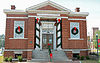 | May 30, 1975 (#75000599) | Jct. of Bellevue/Jackson and Academy Sts. (311 Academy Ave.) 32°32′19″N 82°54′30″W / 32.53864°N 82.90829°W / 32.53864; -82.90829 (Carnegie Library) | Dublin | NRHP form incorrectly gives the location as 32°31'20"N, 82°54'28"W. It is a contributing property to the Dublin Commercial Historic District. |
| 2 | Dublin Commercial Historic District |  | May 22, 2002 (#02000540) | Roughly centered on Jackson Ave. and Lawrence St. 32°32′20″N 82°54′19″W / 32.538889°N 82.905278°W / 32.538889; -82.905278 (Dublin Commercial Historic District) | Dublin | |
| 3 | Dublin Veterans Administration Hospital |  | December 10, 2018 (#100003205) | 1826 Veterans Blvd. 32°32′14″N 82°56′34″W / 32.53711°N 82.94291°W / 32.53711; -82.94291 (Dublin Veterans Administration Hospital) | Dublin | |
| 4 | First African Baptist Church |  | August 16, 2019 (#100004299) | 405 Telfair St. 32°32′08″N 82°54′25″W / 32.53542°N 82.90700°W / 32.53542; -82.90700 (First African Baptist Church) | Dublin | |
| 5 | Fish Trap Cut | Upload image | October 1, 1974 (#74000691) | Address Restricted 32°28′15″N 82°51′28″W / 32.47072°N 82.85764°W / 32.47072; -82.85764 (Fish Trap Cut) | Dublin | Fish Cut Mounds Fish Trap Cut |
| 6 | Sanders Hill | Upload image | May 28, 1975 (#75000600) | S of Montrose off I-16/GA 404. 1.5 miles SW of Montrose, 5.5 miles W of Dudley. One acre surrounded by dirt road to the west and a fence around the rest (1975 NRHP form). 32°32′20″N 83°09′55″W / 32.538889°N 83.165278°W / 32.538889; -83.165278 (Sanders Hill) | Montrose | |
| 7 | Stubbs Park-Stonewall Street Historic District |  | November 7, 2002 (#02001293) | Roughly bounded by W. Moore St., Roosevelt St., Bellevue Ave., Marion St., Academy Ave., Lancaster and Thompson Sts. 32°32′07″N 82°54′59″W / 32.5352°N 82.9165°W / 32.5352; -82.9165 (Stubbs Park-Stonewall Street Historic District) | Dublin | |
| 8 | Emery Thomas Auditorium | Upload image | May 10, 2022 (#100007698) | 100 Riverview Dr. 32°31′28″N 82°53′25″W / 32.5245°N 82.8904°W / 32.5245; -82.8904 (Emery Thomas Auditorium) | Dublin | |
| 9 | United States Post Office and Court House |  | June 15, 2018 (#100002569) | 100 N Franklin St. 32°32′25″N 82°54′12″W / 32.5404°N 82.9032°W / 32.5404; -82.9032 (United States Post Office and Court House) | Dublin | Now the Federal Building and US Courthouse |
References
Wikimedia Commons has media related to National Register of Historic Places in Laurens County, Georgia.
- ^ National Park Service, United States Department of the Interior, "National Register of Historic Places: Weekly List Actions", retrieved August 16, 2024.
- ^ Numbers represent an alphabetical ordering by significant words. Various colorings, defined here, differentiate National Historic Landmarks and historic districts from other NRHP buildings, structures, sites or objects.
- ^ The eight-digit number below each date is the number assigned to each location in the National Register Information System database, which can be viewed by clicking the number.
| |
|---|---|
| Topics | |
| Lists by state |
|
| Lists by insular areas | |
| Lists by associated state | |
| Other areas | |
| Related | |
| |


