National Register of Historic Places listings in Muhlenberg County, Kentucky

This is a list of the National Register of Historic Places listings in Muhlenberg County, Kentucky.
This is intended to be a complete list of the properties and districts on the National Register of Historic Places in Muhlenberg County, Kentucky, United States. The locations of National Register properties and districts for which the latitude and longitude coordinates are included below, may be seen in a map.[1]
There are 13 properties and districts listed on the National Register in the county, of which 1 is part of a National Historic Landmark spread across multiple counties.
This National Park Service list is complete through NPS recent listings posted August 16, 2024.[2]
Map all coordinates using OpenStreetMap
Download coordinates as:
- KML
- GPX (all coordinates)
- GPX (primary coordinates)
- GPX (secondary coordinates)
Current listings
| [3] | Name on the Register | Image | Date listed[4] | Location | City or town | Description |
|---|---|---|---|---|---|---|
| 1 | Baker Site (15MU12) | Upload image | April 1, 1986 (#86000654) | Left bank of the Green River, 3 miles (4.8 km) above the Paradise Fossil Plant[5] 37°14′18″N 86°56′47″W / 37.2383°N 86.9464°W / 37.2383; -86.9464 (Baker Site (15MU12)) | Skilesville | Part of the Green River Shell Middens Archeological District National Historic Landmark[6] |
| 2 | J. A. Gilman House |  | July 14, 2020 (#100005194) | 105 Paradise St. 37°12′17″N 87°10′22″W / 37.2046°N 87.1729°W / 37.2046; -87.1729 (J. A. Gilman House) | Greenville | No information seems to be available online. |
| 3 | Greenville City Hall | 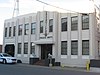 | August 26, 1985 (#85001906) | Court Street 37°12′00″N 87°10′38″W / 37.2001°N 87.1772°W / 37.2001; -87.1772 (Greenville City Hall) | Greenville | |
| 4 | Greenville Commercial Historic District |  | August 15, 1985 (#85001903) | 100 blocks of N. Main and E. Main Cross Sts. 37°12′05″N 87°10′44″W / 37.2014°N 87.1789°W / 37.2014; -87.1789 (Greenville Commercial Historic District) | Greenville | |
| 5 | Martin House |  | August 15, 1985 (#85001900) | 144 E. Main Cross St. 37°12′06″N 87°10′29″W / 37.2017°N 87.1747°W / 37.2017; -87.1747 (Martin House) | Greenville | Demolished in 2013; gazebo (pictured) constructed on site |
| 6 | Muhlenberg County Courthouse |  | December 22, 1978 (#78001390) | Courthouse Sq. 37°12′02″N 87°10′41″W / 37.2006°N 87.1781°W / 37.2006; -87.1781 (Muhlenberg County Courthouse) | Greenville | |
| 7 | North Main Street Historic District |  | August 15, 1985 (#85001904) | 100 and 200 blocks of N. Main St. 37°12′14″N 87°10′44″W / 37.2039°N 87.1789°W / 37.2039; -87.1789 (North Main Street Historic District) | Greenville | |
| 8 | Old Muhlenberg County Jail |  | August 15, 1985 (#85001901) | Court Row 37°12′00″N 87°10′40″W / 37.2°N 87.1778°W / 37.2; -87.1778 (Old Muhlenberg County Jail) | Greenville | Demolished circa 2000 |
| 9 | Rice Tobacco Factory |  | August 15, 1985 (#85001902) | 112 N. Cherry St. 37°12′08″N 87°10′50″W / 37.2022°N 87.1806°W / 37.2022; -87.1806 (Rice Tobacco Factory) | Greenville | |
| 10 | George Short House |  | September 15, 1980 (#80001661) | 121 N. Main St. 37°12′11″N 87°10′45″W / 37.2031°N 87.1792°W / 37.2031; -87.1792 (George Short House) | Greenville | |
| 11 | South Cherry Street Historic District |  | August 15, 1985 (#85001905) | Roughly bounded by S. Cherry, Hopkinsville, W. Main Cross, and N. Cherry Sts. 37°11′59″N 87°10′50″W / 37.1997°N 87.1806°W / 37.1997; -87.1806 (South Cherry Street Historic District) | Greenville | |
| 12 | Edward Taylor House | Upload image | January 2, 2024 (#100009728) | 215 East Main Cross Street 37°12′14″N 87°10′24″W / 37.2040°N 87.1732°W / 37.2040; -87.1732 (Edward Taylor House) | Greenville | |
| 13 | Robert Thomas House | 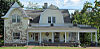 | December 6, 1990 (#90001833) | 516 Broad St. 37°17′45″N 87°07′05″W / 37.2958°N 87.1181°W / 37.2958; -87.1181 (Robert Thomas House) | Central City |
See also
Wikimedia Commons has media related to National Register of Historic Places in Muhlenberg County, Kentucky.
- List of National Historic Landmarks in Kentucky
- National Register of Historic Places listings in Kentucky
References
- ^ The latitude and longitude information provided in this table was derived originally from the National Register Information System, which has been found to be fairly accurate for about 99% of listings. Some locations in this table may have been corrected to current GPS standards.
- ^ National Park Service, United States Department of the Interior, "National Register of Historic Places: Weekly List Actions", retrieved August 16, 2024.
- ^ Numbers represent an alphabetical ordering by significant words. Various colorings, defined here, differentiate National Historic Landmarks and historic districts from other NRHP buildings, structures, sites or objects.
- ^ The eight-digit number below each date is the number assigned to each location in the National Register Information System database, which can be viewed by clicking the number.
- ^ Moore, Christopher R. Production, Exchange, and Social Interaction in the Green River Region of Western Kentucky: A Multiscalar Approach to the Analysis of Two Shell Midden Sites. Diss. University of Kentucky, 2011, 163.
- ^ National Historic Landmark Nomination: Green River Shell Middens. National Park Service: 1994-05-05, 24.
- v
- t
- e
- List of U.S. National Historic Landmarks by state:
- Alabama
- Alaska
- Arizona
- Arkansas
- California
- Colorado
- Connecticut
- Delaware
- Florida
- Georgia
- Hawaii
- Idaho
- Illinois
- Indiana
- Iowa
- Kansas
- Kentucky
- Louisiana
- Maine
- Maryland
- Massachusetts
- Michigan
- Minnesota
- Mississippi
- Missouri
- Montana
- Nebraska
- Nevada
- New Hampshire
- New Jersey
- New Mexico
- New York
- North Carolina
- North Dakota
- Ohio
- Oklahoma
- Oregon
- Pennsylvania
- Rhode Island
- South Carolina
- South Dakota
- Tennessee
- Texas
- Utah
- Vermont
- Virginia
- Washington
- West Virginia
- Wisconsin
- Wyoming
 National Register of Historic Places portal
 Category


Municipalities and communities of Muhlenberg County, Kentucky, United States | ||
|---|---|---|
County seat: Greenville | ||
| Cities |  | |
| CDPs | ||
| Other communities | ||
| Ghost town | ||
| Footnotes | ‡This populated place also has portions in an adjacent county or counties | |
| ||


