National Register of Historic Places listings in Portland, Maine

This is a list of the National Register of Historic Places listings in Portland, Maine.
This is intended to be a complete list of the properties and districts on the National Register of Historic Places in Portland, Cumberland County, Maine, United States. Latitude and longitude coordinates are provided for many National Register properties and districts; these locations may be seen together in an online map.[1]
There are 247 properties and districts listed on the National Register in Cumberland County, including 11 National Historic Landmarks. 149 of these properties and districts, including 4 National Historic Landmarks, are located outside of Portland, and are listed separately, while the 98 properties and districts in Portland are listed here. Two properties in Portland were once listed but have been removed.
This National Park Service list is complete through NPS recent listings posted August 23, 2024.[2]
Map all coordinates using OpenStreetMap
Download coordinates as:
- KML
- GPX (all coordinates)
- GPX (primary coordinates)
- GPX (secondary coordinates)
Current listings
| [3] | Name on the Register[4] | Image | Date listed[5] | Location | Description |
|---|---|---|---|---|---|
| 1 | Abyssinian Meeting House |  | February 3, 2006 (#05001612) | 73-75 Newbury St. 43°39′44″N 70°14′58″W / 43.662222°N 70.249444°W / 43.662222; -70.249444 (Abyssinian Meeting House) | |
| 2 | Back Cove |  | October 16, 1989 (#89001706) | Roughly Baxter Boulevard along Back Cove from Baxter to Veranda Sts. 43°40′25″N 70°16′15″W / 43.673611°N 70.270833°W / 43.673611; -70.270833 (Back Cove) | |
| 3 | Bagheera |  | November 4, 2009 (#09000878) | Maine State Pier, Commercial St. 43°39′24″N 70°14′52″W / 43.656606°N 70.247739°W / 43.656606; -70.247739 (Bagheera) | |
| 4 | Battery Steele |  | October 20, 2005 (#05001176) | Florida Ave. on Peaks Island 43°39′32″N 70°10′50″W / 43.658889°N 70.180556°W / 43.658889; -70.180556 (Battery Steele) | |
| 5 | Harrison B. Brown House |  | June 23, 1980 (#80000227) | 400 Danforth St. 43°38′39″N 70°16′19″W / 43.644167°N 70.271944°W / 43.644167; -70.271944 (Harrison B. Brown House) | |
| 6 | J.B. Brown Memorial Block |  | May 23, 1978 (#78000167) | Congress and Casco Sts. 43°39′21″N 70°15′42″W / 43.655833°N 70.261667°W / 43.655833; -70.261667 (J.B. Brown Memorial Block) | |
| 7 | A.B. Butler House |  | May 8, 1974 (#74000158) | 4 Walker St. 43°39′09″N 70°16′10″W / 43.6526°N 70.2695°W / 43.6526; -70.2695 (A.B. Butler House) | |
| 8 | Cathedral of the Immaculate Conception |  | June 20, 1985 (#85001257) | Cumberland Ave. and Congress St. 43°39′41″N 70°15′17″W / 43.661389°N 70.254722°W / 43.661389; -70.254722 (Cathedral of the Immaculate Conception) | |
| 9 | Leonard Bond Chapman House |  | April 23, 1980 (#80000228) | 90 Capisic St. 43°39′43″N 70°18′10″W / 43.661944°N 70.302778°W / 43.661944; -70.302778 (Leonard Bond Chapman House) | |
| 10 | Chestnut Street Methodist Church |  | October 20, 1977 (#77000063) | 11-19 Chestnut St. 43°39′34″N 70°15′30″W / 43.659444°N 70.258333°W / 43.659444; -70.258333 (Chestnut Street Methodist Church) | |
| 11 | Children's Hospital |  | March 7, 2012 (#12000065) | 68 High St. 43°39′08″N 70°15′38″W / 43.652206°N 70.260441°W / 43.652206; -70.260441 (Children's Hospital) | |
| 12 | Charles Q. Clapp Block |  | January 31, 1978 (#78000168) | Congress Sq. 43°39′15″N 70°15′47″W / 43.654167°N 70.263056°W / 43.654167; -70.263056 (Charles Q. Clapp Block) | |
| 13 | Charles Q. Clapp House |  | February 23, 1972 (#72000072) | 97 Spring St. 43°39′13″N 70°15′43″W / 43.653611°N 70.261944°W / 43.653611; -70.261944 (Charles Q. Clapp House) | |
| 14 | Nathan Clifford School |  | December 18, 2013 (#13000925) | 180 Falmouth St. 43°39′37″N 70°16′49″W / 43.660281°N 70.280317°W / 43.660281; -70.280317 (Nathan Clifford School) | |
| 15 | Deering Estate Barn |  | August 13, 1969 (#09000089) | Falmouth St. on the University of Southern Maine campus 43°39′49″N 70°16′40″W / 43.663611°N 70.277778°W / 43.663611; -70.277778 (Deering Estate Barn) | Demolished 1969.[6] |
| 16 | Deering Oaks |  | October 16, 1989 (#89001708) | Roughly bounded by Interstate 295, Forest St., Park Ave., and Deering Ave. 43°39′32″N 70°16′20″W / 43.658889°N 70.272222°W / 43.658889; -70.272222 (Deering Oaks) | |
| 17 | Deering Street Historic District |  | January 27, 1983 (#83000448) | Congress, Deering, Mellen, and State Sts. 43°39′17″N 70°16′07″W / 43.654722°N 70.268611°W / 43.654722; -70.268611 (Deering Street Historic District) | |
| 18 | Gen. Neal Dow House |  | April 11, 1973 (#73000236) | 714 Congress St. 43°39′11″N 70°16′12″W / 43.653056°N 70.27°W / 43.653056; -70.27 (Gen. Neal Dow House) | |
| 19 | Nathaniel Dyer House | 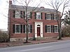 | April 15, 1987 (#86003534) | 168 York St. 43°38′58″N 70°15′34″W / 43.6495°N 70.2594°W / 43.6495; -70.2594 (Nathaniel Dyer House) | |
| 20 | Eastern Cemetery | 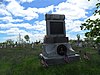 | December 12, 1973 (#73000112) | Congress St. at its junction with Mountfort St. 43°39′46″N 70°15′03″W / 43.662778°N 70.250833°W / 43.662778; -70.250833 (Eastern Cemetery) | |
| 21 | Eastern Promenade |  | October 16, 1989 (#89001707) | Roughly bounded by Eastern Promenade and Casco Bay 43°40′20″N 70°14′50″W / 43.672222°N 70.247222°W / 43.672222; -70.247222 (Eastern Promenade) | |
| 22 | Eighth Maine Regiment Memorial | 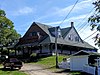 | October 4, 2006 (#06000919) | 13 8th Main Ave., Peaks Island 43°39′09″N 70°11′32″W / 43.6525°N 70.192222°W / 43.6525; -70.192222 (Eighth Maine Regiment Memorial) | |
| 23 | Engine Company Number Nine Firehouse |  | October 28, 2010 (#10000876) | 17 Arbor St. 43°41′08″N 70°17′34″W / 43.685556°N 70.292778°W / 43.685556; -70.292778 (Engine Company Number Nine Firehouse) | |
| 24 | Everett Chambers |  | May 19, 2006 (#06000397) | 47-55 Oak St. 43°39′18″N 70°15′42″W / 43.655°N 70.261667°W / 43.655; -70.261667 (Everett Chambers) | |
| 25 | Evergreen Cemetery |  | June 18, 1992 (#92000791) | Off the western side of Stevens Ave., north of its junction with Brighton Ave. 43°40′51″N 70°18′04″W / 43.680833°N 70.301111°W / 43.680833; -70.301111 (Evergreen Cemetery) | |
| 26 | Fifth Maine Regiment Community Center |  | January 5, 1978 (#78000169) | Seashore Ave. on Peaks Island 43°39′10″N 70°11′36″W / 43.652778°N 70.193333°W / 43.652778; -70.193333 (Fifth Maine Regiment Community Center) | |
| 27 | First Parish Church |  | January 12, 1973 (#73000113) | 425 Congress St. 43°39′30″N 70°15′32″W / 43.658333°N 70.258889°W / 43.658333; -70.258889 (First Parish Church) | |
| 28 | Fort Gorges | 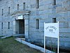 | August 28, 1973 (#73000114) | East of Portland on Hog Island in Portland Harbor 43°39′46″N 70°13′18″W / 43.662778°N 70.221667°W / 43.662778; -70.221667 (Fort Gorges) | |
| 29 | Fort McKinley Historic District |  | March 21, 1985 (#85000611) | Great Diamond Island 43°41′00″N 70°11′47″W / 43.683333°N 70.196389°W / 43.683333; -70.196389 (Fort McKinley Historic District) | |
| 30 | Fort McKinley Torpedo Storehouse | Upload image | March 19, 2024 (#100010087) | 148 Coveside Drive, Great Diamond Island 43°41′00″N 70°11′23″W / 43.6832°N 70.1897°W / 43.6832; -70.1897 (Fort McKinley Torpedo Storehouse) | |
| 31 | Franklin Towers | 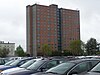 | March 5, 2024 (#100009363) | 211 Cumberland Ave. (Tax ID address 61 Wilmot St.) 43°39′41″N 70°15′22″W / 43.6615°N 70.2561°W / 43.6615; -70.2561 (Franklin Towers) | |
| 32 | The Gothic House |  | December 31, 1974 (#72001539) | 387 Spring St. 43°38′45″N 70°16′30″W / 43.645833°N 70.275°W / 43.645833; -70.275 (The Gothic House) | |
| 33 | Green Memorial A.M.E. Zion Church |  | January 17, 1973 (#73000115) | 46 Sheridan St. 43°39′50″N 70°14′58″W / 43.663889°N 70.249444°W / 43.663889; -70.249444 (Green Memorial A.M.E. Zion Church) | |
| 34 | Byron Greenough Block |  | March 10, 1977 (#77000065) | Free and Middle Sts. 43°39′25″N 70°15′28″W / 43.656944°N 70.257778°W / 43.656944; -70.257778 (Byron Greenough Block) | |
| 35 | Greenwood Garden Playhouse | Upload image | September 10, 2021 (#100006989) | 32 Garden Pl., Peaks Island 43°39′13″N 70°11′54″W / 43.6537°N 70.1983°W / 43.6537; -70.1983 (Greenwood Garden Playhouse) | |
| 36 | Griffin House | 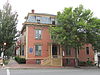 | July 19, 1984 (#84001360) | 200 High St. 43°39′21″N 70°15′59″W / 43.655833°N 70.266389°W / 43.655833; -70.266389 (Griffin House) | |
| 37 | Hamblen Block |  | July 21, 1983 (#83000449) | 188-194 Danforth St. 43°38′54″N 70°15′50″W / 43.648333°N 70.263889°W / 43.648333; -70.263889 (Hamblen Block) | |
| 38 | Hamblen Development Historic District |  | June 18, 1992 (#92000802) | 188-208 Danforth St. 43°38′54″N 70°15′50″W / 43.648333°N 70.263889°W / 43.648333; -70.263889 (Hamblen Development Historic District) | |
| 39 | Asa Hanson Block | 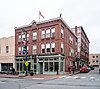 | December 31, 2001 (#01001418) | 548-550 Congress St. 43°39′19″N 70°15′43″W / 43.655278°N 70.261944°W / 43.655278; -70.261944 (Asa Hanson Block) | |
| 40 | How Houses |  | January 20, 1980 (#80000377) | 23 Danforth St., 30-32, 40 Pleasant Sts. 43°39′14″N 70°15′30″W / 43.653889°N 70.258333°W / 43.653889; -70.258333 (How Houses) | A small group of houses belonging to the How family |
| 41 | Daniel How House |  | April 24, 1973 (#73000265) | 23 Danforth St. 43°39′14″N 70°15′30″W / 43.653889°N 70.258333°W / 43.653889; -70.258333 (Daniel How House) | |
| 42 | Joseph Holt Ingraham House |  | July 16, 1973 (#73000116) | 51 State St. 43°39′00″N 70°15′41″W / 43.65°N 70.261389°W / 43.65; -70.261389 (Joseph Holt Ingraham House) | |
| 43 | Lancaster Block |  | September 29, 1982 (#82000745) | 474 Congress St. 43°39′25″N 70°15′35″W / 43.656944°N 70.259722°W / 43.656944; -70.259722 (Lancaster Block) | |
| 44 | Adam P. Leighton House | 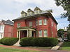 | September 29, 1982 (#82000746) | 261 Western Promenade 43°39′04″N 70°16′34″W / 43.651111°N 70.276111°W / 43.651111; -70.276111 (Adam P. Leighton House) | |
| 45 | Lincoln Park | 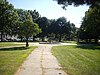 | October 16, 1989 (#89001709) | Bounded by Pearl, Franklin, Market, and Federal Sts. 43°39′35″N 70°15′18″W / 43.659722°N 70.255°W / 43.659722; -70.255 (Lincoln Park) | |
| 46 | Henry Wadsworth Longfellow Monument |  | April 5, 1990 (#90000580) | Southeastern corner of State and Congress Sts. 43°39′11″N 70°16′02″W / 43.653056°N 70.267222°W / 43.653056; -70.267222 (Henry Wadsworth Longfellow Monument) | |
| 47 | Maine Archeological Site No. 9-16 | Upload image | May 7, 1979 (#79000141) | Great Diamond Island[7] | Native American site |
| 48 | Maine Central Railroad General Office Building |  | January 7, 1988 (#87002192) | 222-224 St. John St. 43°39′03″N 70°16′48″W / 43.650833°N 70.28°W / 43.650833; -70.28 (Maine Central Railroad General Office Building) | |
| 49 | Maine Eye and Ear Infirmary | 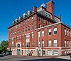 | September 25, 1986 (#86002469) | 794-800 Congress St. 43°39′13″N 70°16′24″W / 43.653611°N 70.273333°W / 43.653611; -70.273333 (Maine Eye and Ear Infirmary) | |
| 50 | Maine Historical Society | 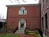 | November 17, 1980 (#80000230) | 485 Congress St. 43°39′25″N 70°15′38″W / 43.656944°N 70.260556°W / 43.656944; -70.260556 (Maine Historical Society) | The Society's 1907 Library Building, located next to the Wadsworth-Longfellow House. |
| 51 | Maine Publicity Bureau Building |  | January 26, 1990 (#89002344) | 501 Danforth St. 43°38′38″N 70°16′34″W / 43.643895°N 70.276083°W / 43.643895; -70.276083 (Maine Publicity Bureau Building) | |
| 52 | Marine Hospital |  | August 21, 1974 (#74000161) | 331 Veranda St. 43°41′18″N 70°14′51″W / 43.688333°N 70.2475°W / 43.688333; -70.2475 (Marine Hospital) | |
| 53 | Mariner's Church |  | April 23, 1973 (#73000117) | 368-374 Fore St. 43°39′23″N 70°15′11″W / 43.656389°N 70.253056°W / 43.656389; -70.253056 (Mariner's Church) | |
| 54 | Masonic Temple | 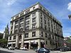 | February 11, 1982 (#82000748) | 415 Congress St. 43°39′32″N 70°15′30″W / 43.658889°N 70.258333°W / 43.658889; -70.258333 (Masonic Temple) | |
| 55 | McLellan-Sweat Mansion |  | March 5, 1970 (#70000073) | 111 High St. 43°39′12″N 70°15′45″W / 43.653333°N 70.2625°W / 43.653333; -70.2625 (McLellan-Sweat Mansion) | |
| 56 | Mechanics' Hall |  | October 3, 1973 (#73000118) | 519 Congress St. 43°39′23″N 70°15′43″W / 43.656389°N 70.261944°W / 43.656389; -70.261944 (Mechanics' Hall) | |
| 57 | William Minott House |  | July 10, 1979 (#79000142) | 45 Park St. 43°39′03″N 70°15′38″W / 43.650833°N 70.260556°W / 43.650833; -70.260556 (William Minott House) | |
| 58 | Morse-Libby Mansion |  | May 19, 1970 (#70000074) | 109 Danforth St. 43°39′06″N 70°15′40″W / 43.651667°N 70.261111°W / 43.651667; -70.261111 (Morse-Libby Mansion) | |
| 59 | North School |  | April 12, 1982 (#82000749) | 248-264 Congress Street 43°39′44″N 70°15′07″W / 43.662222°N 70.251944°W / 43.662222; -70.251944 (North School) | |
| 60 | Park Street Row | 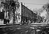 | February 23, 1972 (#72000074) | 88-114 Park St. 43°39′06″N 70°15′46″W / 43.651667°N 70.262778°W / 43.651667; -70.262778 (Park Street Row) | |
| 61 | Porteous, Mitchell and Braun Company Building |  | September 27, 1996 (#96001039) | 522-528 Congress St. 43°39′21″N 70°15′40″W / 43.655833°N 70.261111°W / 43.655833; -70.261111 (Porteous, Mitchell and Braun Company Building) | |
| 62 | Portland City Hall |  | May 7, 1973 (#73000119) | 389 Congress St. 43°39′34″N 70°15′27″W / 43.659444°N 70.2575°W / 43.659444; -70.2575 (Portland City Hall) | |
| 63 | Portland City Hospital |  | March 21, 1985 (#85000612) | Brighton Ave. 43°40′37″N 70°19′31″W / 43.6769°N 70.3253°W / 43.6769; -70.3253 (Portland City Hospital) | |
| 64 | Portland Club | 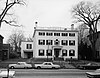 | January 25, 1973 (#73000120) | 156 State St. 43°39′07″N 70°15′58″W / 43.6519°N 70.2661°W / 43.6519; -70.2661 (Portland Club) | |
| 65 | Portland High School | 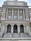 | November 23, 1984 (#84003879) | 284 Cumberland Ave. 43°39′33″N 70°15′34″W / 43.6592°N 70.2594°W / 43.6592; -70.2594 (Portland High School) | |
| 66 | Portland Observatory | 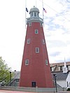 | April 24, 1973 (#73000122) | 138 Congress St. 43°39′56″N 70°14′11″W / 43.6656°N 70.2364°W / 43.6656; -70.2364 (Portland Observatory) | |
| 67 | Portland Packing Company Factory |  | June 7, 1996 (#96000651) | 14-26 York St. 43°39′14″N 70°15′27″W / 43.6539°N 70.2575°W / 43.6539; -70.2575 (Portland Packing Company Factory) | |
| 68 | Portland Soldiers and Sailors Monument |  | April 1, 1998 (#98000308) | Junction of Congress St. and Federal St. 43°39′26″N 70°15′34″W / 43.6572°N 70.2594°W / 43.6572; -70.2594 (Portland Soldiers and Sailors Monument) | |
| 69 | Portland Waterfront Historic District |  | May 2, 1974 (#74000353) | Waterfront area; also 79-85 and 295-309 Commercial and 3 Center Sts.; also Merrill's Wharf, 252-260 Commercial St.; also 113-115 Middle St. 43°39′17″N 70°15′37″W / 43.6547°N 70.2603°W / 43.6547; -70.2603 (Portland Waterfront Historic District) | Addresses on Commercial and Center Sts. represent boundary increases of December 23, 1984 and March 7, 2012; addresses on Middle Street represent a boundary increase approved October 5, 2020. |
| 70 | Rackleff Building |  | May 9, 1973 (#73000123) | 129–131 Middle St. 43°39′31″N 70°15′14″W / 43.6586°N 70.2539°W / 43.6586; -70.2539 (Rackleff Building) | |
| 71 | Thomas Brackett Reed House |  | May 7, 1973 (#73000239) | 30-32 Deering St. 43°39′15″N 70°16′03″W / 43.6542°N 70.2675°W / 43.6542; -70.2675 (Thomas Brackett Reed House) | Home of Thomas Brackett Reed, nineteenth-century Speaker of the United States House of Representatives |
| 72 | Thomas B. Reed School |  | January 6, 2020 (#100004827) | 26 Homestead Ave. 43°41′42″N 70°18′06″W / 43.6950°N 70.3017°W / 43.6950; -70.3017 (Thomas B. Reed School) | |
| 73 | John B. Russwurm House |  | July 21, 1983 (#83000450) | 238 Ocean Ave. 43°40′44″N 70°16′49″W / 43.6789°N 70.2803°W / 43.6789; -70.2803 (John B. Russwurm House) | Home of John B. Russwurm, abolitionist |
| 74 | Sagamore Village Historic District | 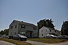 | August 3, 2020 (#100005397) | Cabot, Purchase, Popham, Godfrey, and Josselyn Sts., and portions of Taft and Brighton Aves. 43°40′35″N 70°19′19″W / 43.6764°N 70.3219°W / 43.6764; -70.3219 (Sagamore Village Historic District) | |
| 75 | St. Joseph's Academy and Convent |  | March 27, 2017 (#100000806) | 605 Stevens Ave.; also 631 Stevens Ave. 43°40′44″N 70°17′39″W / 43.6790°N 70.2941°W / 43.6790; -70.2941 (St. Joseph's Academy and Convent) | 631 Stevens Ave. represents a boundary increase approved December 30, 2022. |
| 76 | St. Lawrence Church | 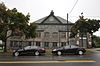 | October 1, 1979 (#79000145) | 76 Congress St. 43°40′01″N 70°14′48″W / 43.6669°N 70.2467°W / 43.6669; -70.2467 (St. Lawrence Church) | Church demolished; parish hall converted to a performing arts center. |
| 77 | St. Paul's Church and Rectory |  | December 22, 1978 (#78000176) | 279 Congress St. 43°39′43″N 70°15′12″W / 43.6619°N 70.2533°W / 43.6619; -70.2533 (St. Paul's Church and Rectory) | |
| 78 | Schlotterbeck and Foss Building |  | July 11, 2016 (#16000436) | 117 Preble St. 43°39′37″N 70°15′48″W / 43.6603°N 70.2632°W / 43.6603; -70.2632 (Schlotterbeck and Foss Building) | |
| 79 | F.O.J. Smith Tomb |  | December 31, 1974 (#74000166) | Evergreen Cemetery 43°40′47″N 70°18′08″W / 43.6797°N 70.3022°W / 43.6797; -70.3022 (F.O.J. Smith Tomb) | |
| 80 | Sparrow House |  | October 29, 1982 (#82000421) | 35 Arlington St. 43°40′12″N 70°16′58″W / 43.67°N 70.2828°W / 43.67; -70.2828 (Sparrow House) | |
| 81 | Spring Street Historic District |  | April 3, 1970 (#70000043) | Roughly bounded by Forest, Oak, Danforth, Brackett and Pine Sts. 43°39′08″N 70°15′50″W / 43.6522°N 70.2639°W / 43.6522; -70.2639 (Spring Street Historic District) | |
| 82 | John Calvin Stevens House |  | July 16, 1973 (#73000125) | 52 Bowdoin St. 43°38′48″N 70°16′30″W / 43.6467°N 70.275°W / 43.6467; -70.275 (John Calvin Stevens House) | |
| 83 | Stroudwater Historic District | 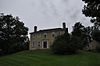 | February 16, 1973 (#73000126) | Residential area at the confluence of the Stroudwater and Fore Rivers 43°39′24″N 70°18′52″W / 43.6567°N 70.3144°W / 43.6567; -70.3144 (Stroudwater Historic District) | |
| 84 | Tate House |  | January 12, 1970 (#70000072) | 1270 Westbrook St. 43°39′25″N 70°18′43″W / 43.656944°N 70.311944°W / 43.656944; -70.311944 (Tate House) | |
| 85 | Thompson Block |  | February 28, 1973 (#73000127) | 117, 119, 121, 123, and 125 Middle St. 43°39′32″N 70°15′11″W / 43.658889°N 70.253056°W / 43.658889; -70.253056 (Thompson Block) | |
| 86 | Timberwind (Schooner) |  | March 26, 1992 (#92000274) | Maine State Pier, Commercial St. Coordinates missing | Moved from Rockport to Belfast in 2015 and to Portland in 2018.[8] |
| 87 | Tracy-Causer Block |  | March 17, 1994 (#89001941) | 505-509 Fore St. 43°39′18″N 70°15′26″W / 43.655°N 70.257222°W / 43.655; -70.257222 (Tracy-Causer Block) | |
| 88 | Trefethen-Evergreen Improvement Association | Upload image | March 19, 2024 (#100010086) | 12 Trefethen Avenue, Peaks Island 43°40′09″N 70°11′31″W / 43.6692°N 70.1920°W / 43.6692; -70.1920 (Trefethen-Evergreen Improvement Association) | |
| 89 | U.S. Courthouse |  | February 12, 1974 (#74000168) | 156 Federal St. 43°39′31″N 70°15′42″W / 43.658611°N 70.261667°W / 43.658611; -70.261667 (U.S. Courthouse) | |
| 90 | U.S. Customhouse |  | May 17, 1973 (#73000128) | 312 Fore St. 43°39′26″N 70°15′05″W / 43.657222°N 70.251389°W / 43.657222; -70.251389 (U.S. Customhouse) | |
| 91 | US Post Office-Portland Main | 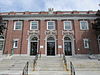 | May 9, 1986 (#86001011) | 125 Forest Avenue 43°39′30″N 70°16′00″W / 43.658333°N 70.266667°W / 43.658333; -70.266667 (US Post Office-Portland Main) | |
| 92 | Wadsworth-Longfellow House | 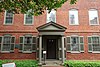 | October 15, 1966 (#66000090) | 487 Congress St. 43°39′23″N 70°15′40″W / 43.656389°N 70.261111°W / 43.656389; -70.261111 (Wadsworth-Longfellow House) | |
| 93 | Wendameen (Yacht) | 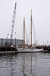 | March 26, 1992 (#92000273) | Maine State Pier, Commercial St. 43°39′26″N 70°14′55″W / 43.657160°N 70.248559°W / 43.657160; -70.248559 (Wendameen (Yacht)) | Although listed in Camden, she is now based in Portland.[9] |
| 94 | Westbrook College Historic District |  | September 15, 1977 (#77000066) | 716 Stevens Ave. 43°41′00″N 70°17′45″W / 43.683333°N 70.295833°W / 43.683333; -70.295833 (Westbrook College Historic District) | |
| 95 | Western Promenade | 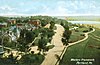 | October 16, 1989 (#89001710) | Roughly Western Promenade from Maine Medical Center to Valley St. 43°38′48″N 70°16′32″W / 43.646667°N 70.275556°W / 43.646667; -70.275556 (Western Promenade) | |
| 96 | Western Promenade Historic District | 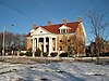 | February 16, 1984 (#84001363) | Roughly bounded by Western Promenade and Bramhall, Brackett, Emery, and Danforth Sts. 43°38′54″N 70°16′19″W / 43.648333°N 70.271944°W / 43.648333; -70.271944 (Western Promenade Historic District) | |
| 97 | Williston-West Church and Parish House | 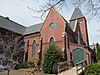 | June 22, 1980 (#80000232) | 32 Thomas St. 43°38′52″N 70°16′16″W / 43.647778°N 70.271111°W / 43.647778; -70.271111 (Williston-West Church and Parish House) | |
| 98 | Woodman Building | 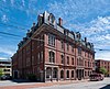 | February 23, 1972 (#72000075) | 133-141 Middle St. 43°39′31″N 70°15′15″W / 43.658611°N 70.254167°W / 43.658611; -70.254167 (Woodman Building) |
Former listings
| [3] | Name on the Register | Image | Date listed | Date removed | Location | Description |
|---|---|---|---|---|---|---|
| 1 | First Baptist Church | Upload image | January 31, 1978 (#78000170) | July 14, 2015 | 353 Congress St. 43°39′37″N 70°15′20″W / 43.660278°N 70.255556°W / 43.660278; -70.255556 (First Baptist Church) | |
| 2 | Portland Stove Foundry | Upload image | November 18, 1974 (#74000164) | January 22, 2009 | 57 Kennebec St. 43°39′44″N 70°15′40″W / 43.6622°N 70.2611°W / 43.6622; -70.2611 (Portland Stove Foundry) | Significantly damaged by fires in 1989[10] and 1991. Subsequently demolished. |
See also
Wikimedia Commons has media related to National Register of Historic Places in Portland, Maine.
References
- ^ The latitude and longitude information provided in this table was derived originally from the National Register Information System, which has been found to be fairly accurate for about 99% of listings. Some locations in this table may have been corrected to current GPS standards.
- ^ National Park Service, United States Department of the Interior, "National Register of Historic Places: Weekly List Actions", retrieved August 23, 2024.
- ^ a b Numbers represent an alphabetical ordering by significant words. Various colorings, defined here, differentiate National Historic Landmarks and historic districts from other NRHP buildings, structures, sites or objects.
- ^ "National Register Information System". National Register of Historic Places. National Park Service. April 24, 2008.
- ^ The eight-digit number below each date is the number assigned to each location in the National Register Information System database, which can be viewed by clicking the number.
- ^ "Deering Barn, ca. 1947". Maine Memory Network. Retrieved 2015-12-22.
- ^ "Portland Comprehensive Plan, Part 1B" (PDF). City of Portland. Retrieved 2010-10-09.[permanent dead link]
- ^ Historic Belfast-based schooner sold, moving to Portland
- ^ "Portland Schooner Company - sailing Portland Maine's only historic windjammers". Archived from the original on 2015-07-15. Retrieved 2016-04-12.
- ^ "No cause found for foundry fire". Sun Journal (Lewiston, Maine). February 24, 1989. p. 4A. Retrieved July 6, 2022 – via Newspapers.com.
- v
- t
- e
- List of U.S. National Historic Landmarks by state:
- Alabama
- Alaska
- Arizona
- Arkansas
- California
- Colorado
- Connecticut
- Delaware
- Florida
- Georgia
- Hawaii
- Idaho
- Illinois
- Indiana
- Iowa
- Kansas
- Kentucky
- Louisiana
- Maine
- Maryland
- Massachusetts
- Michigan
- Minnesota
- Mississippi
- Missouri
- Montana
- Nebraska
- Nevada
- New Hampshire
- New Jersey
- New Mexico
- New York
- North Carolina
- North Dakota
- Ohio
- Oklahoma
- Oregon
- Pennsylvania
- Rhode Island
- South Carolina
- South Dakota
- Tennessee
- Texas
- Utah
- Vermont
- Virginia
- Washington
- West Virginia
- Wisconsin
- Wyoming
 National Register of Historic Places portal
 Category


