National Register of Historic Places listings in Saguache County, Colorado
List of National Register of Historic Places in Saguache County, Colorado, United States

This is a list of the National Register of Historic Places listings in Saguache County, Colorado.
This is intended to be a complete list of the properties and districts on the National Register of Historic Places in Saguache County,[a] Colorado, United States. The locations of National Register properties and districts for which the latitude and longitude coordinates are included below, may be seen in a map.[3]
There are 10 properties and districts listed on the National Register in the county.
This National Park Service list is complete through NPS recent listings posted September 5, 2024.[4]
- v
- t
- e
Properties on the National Register of Historic Places in Colorado by county
- Adams
- Alamosa
- Arapahoe
- Archuleta
- Baca
- Bent
- Boulder
- Broomfield
- Chaffee
- Cheyenne
- Clear Creek
- Conejos
- Costilla
- Crowley
- Custer
- Delta
- Denver
- Dolores
- Douglas
- Eagle
- El Paso
- Elbert
- Fremont
- Garfield
- Gilpin
- Grand
- Gunnison
- Hinsdale
- Huerfano
- Jackson
- Jefferson
- Kiowa
- Kit Carson
- La Plata
- Lake
- Larimer
- Las Animas
- Lincoln
- Logan
- Mesa
- Mineral
- Moffat
- Montezuma
- Montrose
- Morgan
- Otero
- Ouray
- Park
- Phillips
- Pitkin
- Prowers
- Pueblo
- Rio Blanco
- Rio Grande
- Routt
- Saguache
- San Juan
- San Miguel
- Sedgwick
- Summit
- Teller
- Washington
- Weld
- Yuma

Map all coordinates using OpenStreetMap
Download coordinates as:
- KML
- GPX (all coordinates)
- GPX (primary coordinates)
- GPX (secondary coordinates)
Current listings
| [5] | Name on the Register[6] | Image | Date listed[7] | Location | City or town | Description |
|---|---|---|---|---|---|---|
| 1 | Baca Land Grant No. 4-Baca Ranch Rural Historic Landscape | Upload image | September 18, 2023 (#100009333) | Cty. Rd. T 37°59′17″N 105°47′09″W / 37.9881°N 105.7858°W / 37.9881; -105.7858 (Baca Land Grant No. 4-Baca Ranch Rural Historic Landscape) | Crestone | |
| 2 | Capilla de San Juan Bautista |  | February 8, 1980 (#80000926) | Northwest of La Garita 37°51′01″N 106°15′46″W / 37.850278°N 106.262778°W / 37.850278; -106.262778 (Capilla de San Juan Bautista) | La Garita | |
| 3 | Carnero Creek Pictographs |  | June 5, 1975 (#75000540) | Address Restricted | La Garita | |
| 4 | Crestone School |  | January 9, 1986 (#86000011) | Cottonwood St. and Carbonate Ave. 37°59′48″N 105°41′57″W / 37.996667°N 105.699167°W / 37.996667; -105.699167 (Crestone School) | Crestone | |
| 5 | First Baptist Church of Moffat |  | July 24, 2008 (#08000710) | 401 Lincoln Ave. 37°59′54″N 105°54′20″W / 37.998342°N 105.905543°W / 37.998342; -105.905543 (First Baptist Church of Moffat) | Moffat | Ornamental Concrete Block Buildings in Colorado Multiple Property Submission |
| 6 | Indian Grove |  | March 24, 2000 (#00000237) | Address Restricted 37°47′18″N 105°30′35″E / 37.7882°N 105.5097°E / 37.7882; 105.5097 (Indian Grove) | Mosca | |
| 7 | Saguache Downtown Historic District | 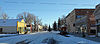 | July 25, 2014 (#14000433) | Roughly 300 & 400 blocks of 4th St. 38°05′14″N 106°08′13″W / 38.0871°N 106.1369°W / 38.0871; -106.1369 (Saguache Downtown Historic District) | Saguache | |
| 8 | Saguache Flour Mill |  | September 18, 1978 (#78000885) | West of Saguache 38°04′53″N 106°09′38″W / 38.081389°N 106.160556°W / 38.081389; -106.160556 (Saguache Flour Mill) | Saguache | |
| 9 | Saguache School and Jail Buildings |  | May 2, 1975 (#75000541) | U.S. Highway 285 and San Juan Ave. 38°05′16″N 106°08′38″W / 38.087778°N 106.143889°W / 38.087778; -106.143889 (Saguache School and Jail Buildings) | Saguache | |
| 10 | Sargents Water Tank, Denver and Rio Grande Railroad, Western Line | 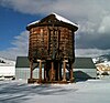 | August 12, 2010 (#10000537) | 45 Front St. 38°24′16″N 106°24′57″W / 38.404444°N 106.415833°W / 38.404444; -106.415833 (Sargents Water Tank, Denver and Rio Grande Railroad, Western Line) | Sargents | Railroads in Colorado, 1858-1948 MPS |
See also
 History portal
 United States portal
 Colorado portal
 National Register of Historic Places portal


- List of National Historic Landmarks in Colorado
- List of National Register of Historic Places in Colorado
- Bibliography of Colorado
- Geography of Colorado
- History of Colorado
- Index of Colorado-related articles
- List of Colorado-related lists
- Outline of Colorado
Notes
- ^ The place name "Saguache" is pronounced /səˈwɑːtʃ/. This name derives from either the Ute language noun "sawup" /səˈwʌp/ meaning "sand dunes"[1] or the Ute phrase "Sa qua qua chi pa" meaning "water of the blue earth."[2] The Spanish language version of this name is usually spelled "Saguache", while the English language version is usually spelled "Sawatch".
References
- ^ Merkl, Dameon (February 26, 2013), "What's in a Colorado name pronunciation?", The Denver Post, retrieved March 7, 2013
- ^ Benson, Maxine (1994). 1001 Colorado Place Names. Lawrence: University Press of Kansas. ISBN 0-7006-0632-7.
- ^ The latitude and longitude information provided in this table was derived originally from the National Register Information System, which has been found to be fairly accurate for about 99% of listings. Some locations in this table may have been corrected to current GPS standards.
- ^ National Park Service, United States Department of the Interior, "National Register of Historic Places: Weekly List Actions", retrieved September 5, 2024.
- ^ Numbers represent an alphabetical ordering by significant words. Various colorings, defined here, differentiate National Historic Landmarks and historic districts from other NRHP buildings, structures, sites or objects.
- ^ "National Register Information System". National Register of Historic Places. National Park Service. July 9, 2010.
- ^ The eight-digit number below each date is the number assigned to each location in the National Register Information System database, which can be viewed by clicking the number.
External links
Wikimedia Commons has media related to Saguache County, Colorado.
- State of Colorado
- History Colorado
- Saguache County, Colorado
| |
|---|---|
| Topics | |
| Lists by state |
|
| Lists by insular areas | |
| Lists by associated state | |
| Other areas | |
| Related | |
| |


Municipalities and communities of Saguache County, Colorado, United States | ||
|---|---|---|
County seat: Saguache | ||
| Towns |  | |
| Unincorporated communities | ||
| Ghost towns | ||
| Footnotes | ‡This populated place also has portions in an adjacent county or counties | |
| ||
| |
|---|---|
Denver (capital) | |
| Topics |
|
| Society | |
| Cities |
|
| Counties |
|
| Regions |
|
 Colorado portal Colorado portal | |
38°04′51″N 106°16′51″W / 38.0807°N 106.2809°W / 38.0807; -106.2809 (Saguache County, Colorado)


