National Register of Historic Places listings in Tooele County, Utah
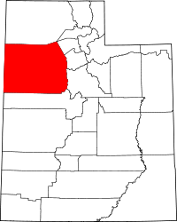
This is a list of the National Register of Historic Places listings in Tooele County, Utah.
This is intended to be a complete list of the properties and districts on the National Register of Historic Places in Tooele County, Utah, United States. Latitude and longitude coordinates are provided for many National Register properties and districts; these locations may be seen together in a map.[1]
There are 30 properties listed on the National Register in the county, including 1 National Historic Landmark.
This National Park Service list is complete through NPS recent listings posted August 9, 2024.[2]
Current listings
| [3] | Name on the Register[4] | Image | Date listed[5] | Location | City or town | Description |
|---|---|---|---|---|---|---|
| 1 | Anderson-Clark Farmstead |  | February 3, 2006 (#05001627) | 378 W. Clark St. 40°36′10″N 112°28′37″W / 40.6028°N 112.4769°W / 40.6028; -112.4769 (Anderson-Clark Farmstead) | Grantsville | |
| 2 | Benson Mill |  | April 14, 1972 (#72001260) | 325 S. State Route 138 40°39′03″N 112°17′47″W / 40.6508°N 112.2964°W / 40.6508; -112.2964 (Benson Mill) | Stansbury Park | |
| 3 | Black Rock Site |  | March 24, 2021 (#100006332) | 2.5 miles (4.0 km) west of jct. UT 202 and I 80 40°43′30″N 112°13′40″W / 40.72503°N 112.22774°W / 40.72503; -112.22774 (Black Rock Site) | Lake Point vicinity | Black Rock and the foundation ruins of Black Rock Resort. Listed area extends into Salt Lake County. |
| 4 | Bonneville Salt Flats Race Track |  | December 18, 1975 (#75001826) | 3 miles (4.8 km) east of Wendover off Interstate 80 40°47′41″N 113°47′37″W / 40.7947°N 113.7936°W / 40.7947; -113.7936 (Bonneville Salt Flats Race Track) | Wendover | |
| 5 | Peter Clegg House |  | September 30, 2019 (#100004483) | 8 South 100 East 40°31′49″N 112°17′45″W / 40.5303°N 112.2957°W / 40.5303; -112.2957 (Peter Clegg House) | Tooele | |
| 6 | Danger Cave | 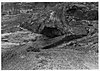 | October 15, 1966 (#66000741) | Northeast of Wendover off Interstate 80 40°44′58″N 114°00′51″W / 40.7494°N 114.0142°W / 40.7494; -114.0142 (Danger Cave) | Wendover | |
| 7 | David E. Davis House |  | November 8, 2007 (#07001172) | 400 E. State Route 199 40°20′14″N 112°26′10″W / 40.3372°N 112.4361°W / 40.3372; -112.4361 (David E. Davis House) | Rush Valley | |
| 8 | Hilda Erickson House |  | July 11, 2006 (#05001626) | 247 W. Main St. 40°35′59″N 112°28′15″W / 40.5997°N 112.4708°W / 40.5997; -112.4708 (Hilda Erickson House) | Grantsville | |
| 9 | GAPA Launch Site and Blockhouse | Upload image | August 26, 1980 (#80003972) | Northeast of Knolls 40°49′41″N 113°12′07″W / 40.8281°N 113.2019°W / 40.8281; -113.2019 (GAPA Launch Site and Blockhouse) | Knolls | |
| 10 | Grantsville First Ward Meetinghouse | 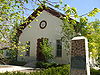 | February 11, 1982 (#82004165) | 297 W. Clark St. 40°36′07″N 112°28′21″W / 40.6019°N 112.4725°W / 40.6019; -112.4725 (Grantsville First Ward Meetinghouse) | Grantsville | |
| 11 | Grantsville School and Meetinghouse | 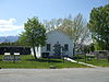 | December 13, 1995 (#95001432) | 90 N. Cooley St. 40°36′08″N 112°28′22″W / 40.6022°N 112.4728°W / 40.6022; -112.4728 (Grantsville School and Meetinghouse) | Grantsville | |
| 12 | Iosepa Settlement Cemetery | 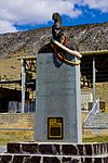 | August 12, 1971 (#71000856) | Skull Valley 40°32′25″N 112°43′57″W / 40.5403°N 112.7325°W / 40.5403; -112.7325 (Iosepa Settlement Cemetery) | Iosepa | |
| 13 | Johnson Hall-Deseret Mercantile Building |  | February 3, 2006 (#05001628) | 4 W. Main St. 40°36′00″N 112°27′49″W / 40.6°N 112.4636°W / 40.6; -112.4636 (Johnson Hall-Deseret Mercantile Building) | Grantsville | |
| 14 | Alex and Mary Alice Johnson House | 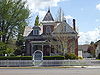 | December 13, 1995 (#95001433) | 5 W. Main St. 40°35′59″N 112°27′47″W / 40.5997°N 112.4631°W / 40.5997; -112.4631 (Alex and Mary Alice Johnson House) | Grantsville | |
| 15 | The Kirk Hotel |  | January 21, 2020 (#100004880) | 57 West Vine St. 40°31′49″N 112°18′01″W / 40.5304°N 112.3003°W / 40.5304; -112.3003 (The Kirk Hotel) | Tooele | Hotel built in 1927-28. |
| 16 | Lawrence Brothers and Company Store |  | October 16, 2013 (#13000842) | 31 E. Main St. 40°22′09″N 112°15′23″W / 40.3692°N 112.2564°W / 40.3692; -112.2564 (Lawrence Brothers and Company Store) | Ophir | |
| 17 | Lincoln Highway Bridge |  | May 21, 1975 (#75001825) | In Ditto Area on 2nd St. over Government Creek, just south of Tucker St. 40°10′58″N 112°55′23″W / 40.1828°N 112.9231°W / 40.1828; -112.9231 (Lincoln Highway Bridge) | Dugway Proving Ground | |
| 18 | Ophir Town Hall |  | June 9, 1983 (#83003193) | 57 E. Main St. 40°22′12″N 112°15′15″W / 40.3699°N 112.2543°W / 40.3699; -112.2543 (Ophir Town Hall) | Ophir | |
| 19 | Reddick Hotel-Ophir LDS Meetinghouse |  | September 27, 2016 (#16000680) | 2nd bldg. W. of Moore St., S. Side of Main St. 40°22′11″N 112°15′19″W / 40.3696°N 112.2553°W / 40.3696; -112.2553 (Reddick Hotel-Ophir LDS Meetinghouse) | Ophir | |
| 20 | John T. Rich House |  | May 2, 1984 (#84002423) | 275 W. Clark St. 40°36′07″N 112°28′18″W / 40.6019°N 112.4717°W / 40.6019; -112.4717 (John T. Rich House) | Grantsville | |
| 21 | John C. Sharp House |  | July 13, 1984 (#84002424) | Off State Route 36 40°05′16″N 112°26′03″W / 40.0878°N 112.4342°W / 40.0878; -112.4342 (John C. Sharp House) | Vernon | |
| 22 | Soldier Creek Kilns |  | August 19, 1980 (#80003973) | Address Restricted[6] | Stockton | |
| 23 | Stockton Jail |  | May 9, 1985 (#85000965) | 38 W. Clark St. 40°27′14″N 112°21′47″W / 40.4539°N 112.3631°W / 40.4539; -112.3631 (Stockton Jail) | Stockton | |
| 24 | Stockton School |  | December 31, 2018 (#100003269) | 18 N. Johnson St. 40°27′05″N 112°21′36″W / 40.4515°N 112.36°W / 40.4515; -112.36 (Stockton School) | Stockton | Built 1912, currently houses Stockton Town Hall |
| 25 | Tooele Carnegie Library |  | October 29, 1984 (#84000420) | 47 E. Vine St. 40°31′52″N 112°17′48″W / 40.5311°N 112.2967°W / 40.5311; -112.2967 (Tooele Carnegie Library) | Tooele | |
| 26 | Tooele City Downtown Historic District | Upload image | July 28, 2023 (#100009199) | 201 North to 154 South Main St., 24-30 West 100 South, 96 West to 48 East Vine St. 40°31′51″N 112°17′55″W / 40.5307°N 112.2986°W / 40.5307; -112.2986 (Tooele City Downtown Historic District) | Tooele | |
| 27 | Tooele County Courthouse and City Hall |  | July 21, 1983 (#83003194) | 41 E. Vine St. 40°31′52″N 112°17′49″W / 40.5311°N 112.2969°W / 40.5311; -112.2969 (Tooele County Courthouse and City Hall) | Tooele | |
| 28 | Tooele Valley Railroad Complex | 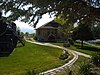 | May 17, 1984 (#84002426) | 35 N. Broadway 40°31′52″N 112°17′17″W / 40.5311°N 112.2881°W / 40.5311; -112.2881 (Tooele Valley Railroad Complex) | Tooele | |
| 29 | Wendover Air Force Base | 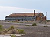 | July 1, 1975 (#75001827) | South Wendover (via 1st Street) 40°43′14″N 114°01′29″W / 40.7206°N 114.0247°W / 40.7206; -114.0247 (Wendover Air Force Base) | Wendover | |
| 30 | James and Penninah Wrathall House | 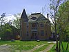 | February 3, 2006 (#05001629) | 5 N. Center St. 40°36′01″N 112°28′10″W / 40.6003°N 112.4694°W / 40.6003; -112.4694 (James and Penninah Wrathall House) | Grantsville |
See also
References
- ^ The latitude and longitude information provided in this table was derived originally from the National Register Information System, which has been found to be fairly accurate for about 99% of listings. Some locations in this table may have been corrected to current GPS standards.
- ^ National Park Service, United States Department of the Interior, "National Register of Historic Places: Weekly List Actions", retrieved August 9, 2024.
- ^ Numbers represent an alphabetical ordering by significant words. Various colorings, defined here, differentiate National Historic Landmarks and historic districts from other NRHP buildings, structures, sites or objects.
- ^ "National Register Information System". National Register of Historic Places. National Park Service. April 24, 2008.
- ^ The eight-digit number below each date is the number assigned to each location in the National Register Information System database, which can be viewed by clicking the number.
- ^ Some listings on the NRHP are highly sensitive sites and may be subject to looting or vandalism. The NRHP lists this site as "Address Restricted."
External links
Map all coordinates using OpenStreetMap
Download coordinates as:
- KML
- GPX (all coordinates)
- GPX (primary coordinates)
- GPX (secondary coordinates)
![]() Media related to National Register of Historic Places in Tooele County, Utah at Wikimedia Commons
Media related to National Register of Historic Places in Tooele County, Utah at Wikimedia Commons
- v
- t
- e

| |
|---|---|
| Topics | |
| Lists by state |
|
| Lists by insular areas | |
| Lists by associated state | |
| Other areas | |
| Related | |
| |


Municipalities and communities of Tooele County, Utah, United States | ||
|---|---|---|
County seat: Tooele | ||
| Cities |  | |
| Towns | ||
| Townships | ||
| CDPs | ||
| Unincorporated communities | ||
| Ghost towns | ||
| Indian reservations | ||
| Footnotes | ‡This populated place also has portions in an adjacent county or counties | |
| ||


