Püspökladány
Town in Hajdú-Bihar, Hungary

Flag

Coat of arms
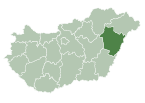
 Hungary
 (2001)
4150
Püspökladány (pronounced [ˈpyʃpøklɒdaːɲ]) is the sixth largest town of Hajdú-Bihar county in North Eastern Hungary with a population of approximately 16,000 people. It is located southwest of Debrecen at the juncture of three regions: Sárrét, Hortobágy and Nagykunság. It is an important transportation hub at the junction of national highway 4 from Budapest to Záhony, and national highway No. 42 from Romania to Biharkeresztes. The town is served by four different rail lines.
Twin towns – sister cities
Püspökladány is twinned with:[1]
 Fischamend, Austria
 Ghindari, Romania
 Hämeenlinna, Finland
 Hattem, Netherlands
 Krasnystaw, Poland


References
- ^ "Testvérvárosok". puspokladany.hu (in Hungarian). Püspökladány. Retrieved 2021-03-28.
External links
Wikimedia Commons has media related to Püspökladány.
- Official website in Hungarian
- Health Spa in Püspökladány
- Welcome to Püspökladány

| ||
|---|---|---|
| City with county rights |
|   |
| Towns | ||
| Large villages | ||
| Villages |
| |
| Other topics |
| |
Authority control databases | |
|---|---|
| International |
|
| National |
|
| Geographic |
|
 | This Hajdú-Bihar location article is a stub. You can help Wikipedia by expanding it. |
- v
- t
- e


