Pana, Afghanistan
Place in Ghazni Province, Afghanistan
Pana پانا | |
|---|---|
| 33°6′1″N 68°18′42″E / 33.10028°N 68.31167°E / 33.10028; 68.31167 | |
| Country |  Afghanistan Afghanistan |
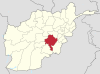
| Province | Ghazni Province |
| District | Giro District |
| Elevation | 2,080 m (6,820 ft) |
| Time zone | UTC+4:30 |
Pana (Panah) is the district center of Giro District, Ghazni Province, Afghanistan. It is located on 33°06′01″N 68°18′42″E / 33.100337°N 68.311612°E / 33.100337; 68.311612[1] at 2,080 m altitude in the central part of the district. The roads towards it are in bad condition.
See also
- Ghazni Province
References
- ^ Pana can be found at GEOnet Names Server, at this link, by opening the Advanced Search box, entering "-3386302" in the "Unique Feature Id" form, and clicking on "Search Database".
Wikimedia Commons has media related to Pana, Afghanistan.
- v
- t
- e
Ghazni Province
Capital: Ghazni
- Ab Band
- Almaytu
- Andar
- Anguri
- Binisang
- Dado
- Du Abi
- Espandi 'Olya
- Gulbawri
- Haji Khel
- Janda
- Jermatu
- Kakrak Valley
- Khogyani
- Khwaja Umari
- Loman
- Malistan
- Mir Adina
- Miray
- Muqur
- Nani
- Nawa
- Pana
- Qarabagh
- Qolyaqol
- Qyaq Valley
- Ramak
- Sang-e-Masha
- Sangar
- Sarab
- Sardeh Band
- Shaki Valley
- Tamaki
- Turgan Valley
- Zargari
 | This Ghazni Province, Afghanistan location article is a stub. You can help Wikipedia by expanding it. |
- v
- t
- e


