Perpendicular Point


Perpendicular Point
class=notpageimage|
Location of Perpendicular Point
Perpendicular Point is a small headland on the West Coast of New Zealand's South Island, overlooking the Tasman Sea. It lies about 40 km south-south-west of Cape Foulwind, close to the small community of Te Miko. Perpendicular Point was known as Te Miko to Māori. A notorious obstacle to coastal travel, the cliffs had ladders built from rātā vine and harakeke, later replaced by chains and rungs, until a reliable inland road was built in the 1860s.
Important Bird Area
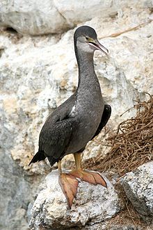
The point has been identified as an Important Bird Area, by BirdLife International because the coastal cliffs in its vicinity are a breeding site for over 500 pairs of spotted shags.[1]
References
- ^ BirdLife International. (2012). Important Bird Areas factsheet: Te Miko & Perpendicular Point. Downloaded from http://www.birdlife.org on 2012-02-17.
42°05′02″S 171°20′30″E / 42.08389°S 171.34167°E / -42.08389; 171.34167
- v
- t
- e
Buller District, New Zealand
Seat: Westport
| Inangahua Ward |
|
|---|---|
| Seddon Ward | |
| Westport Ward |
- Allen River
- Awakari River
- Awarau River
- Ballroom Overhang
- Beautiful River
- Blackwater River (Buller River tributary)
- Blackwater River (Little Grey River tributary)
- Buller Gorge
- Buller River
- Bullock Creek
- Denniston Plateau
- Fox River
- Glasgow Range
- Kahurangi Point
- Karamea Bight
- Lake Christabel
- Lewis Pass
- Metro Cave / Te Ananui Cave
- Mount Augustus
- Mount Haast
- Ngākawau River
- Ōpārara Basin
- Ōpārara Basin Arches
- Ōtūmahana Estuary
- Papahaua Range
- Paparoa Range
- Perpendicular Point
- Pororari River
- Scotts Beach
- Waitakere / Nile River
- Wharepapa / Arthur Range
- Big Rimu Walk
- Charming Creek Tramway
- Conns Creek Branch
- Fenian Track
- Granity Community Library
- Heaphy Track
- Inland Pack Track
- Kahurangi Marine Reserve
- Kahurangi National Park
- Karamea Centennial Museum
- Koranui Incline
- Mokihinui Hydro
- Ngakawau Hydro Project
- Old Ghost Road
- Pancake Rocks and Blowholes
- Paparoa National Park
- Punakaiki Marine Reserve
- Reefton Hospital
- Rockies Incline
- Seddonville Branch
- Stillwater–Ngākawau Line
- Stockton Mine
- Truman Track
- Victoria Forest Park
- Wangapeka Track
- Westport Airport
 | This West Coast Region (New Zealand) geography article is a stub. You can help Wikipedia by expanding it. |
- v
- t
- e


