Perrineville, New Jersey
Populated place in Monmouth County, New Jersey, US
Unincorporated community in New Jersey, United States
40°13′42″N 74°26′27″W / 40.22833°N 74.44083°W / 40.22833; -74.44083 United States
 New Jersey
[1]
08535

Perrineville is an unincorporated community located within Millstone Township in Monmouth County, in the U.S. state of New Jersey.[2] The area is served as United States Postal Service ZIP Code 08535.
As of the 2000 United States Census, the population for ZIP Code Tabulation Area 08535 was 2,073.[3]
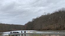
Perrineville is located 157 feet (48 m) above sea level and is centered on Perrineville Road (County Route 1) near Agress Road.[4] A lake in the center of the community, Perrineville Lake, is a preserved area maintained by the Monmouth County Park System.[5]
Perrineville is home to the Perrineville Jewish Center, a synagogue established in 1910 in the center of the community. More than 130 families attend prayer services regularly, led by Rabbi Sheldon Schevelowitz.[6]
References
- ^ a b "Perrineville". Geographic Names Information System. United States Geological Survey, United States Department of the Interior.
- ^ Locality Search, State of New Jersey. Accessed February 28, 2015.
- ^ Census 2000 Fact Sheet for ZIP Code Tabulation Area 08535[permanent dead link], United States Census Bureau. Accessed July 23, 2008.
- ^ Monmouth County (PDF) (Map). New Jersey Department of Transportation. Retrieved February 8, 2015.
- ^ "Monmouth County Park System Parks - Perrineville Lake Park". Monmouth County Park System. Retrieved February 8, 2015.
- ^ Garbi, Jill. "100 years of tilling a fruitful field; Perrineville Jewish Center: from 10 farmers to 'tight' community", New Jersey Jewish News, November 15, 2010. Accessed June 9, 2016. "One hundred years ago, 10 Jewish newcomers to western Monmouth County planted the seeds of the First Hebrew Farmers Association in Perrineville."
Wikimedia Commons has media related to Perrineville, New Jersey.
- v
- t
- e
Municipalities and communities of Monmouth County, New Jersey, United States
County seat: Freehold Borough

- Allenhurst
- Allentown
- Atlantic Highlands
- Avon-by-the-Sea
- Belmar
- Bradley Beach
- Brielle
- Deal
- Eatontown
- Englishtown
- Fair Haven
- Farmingdale
- Freehold Borough
- Highlands
- Interlaken
- Keansburg
- Keyport
- Lake Como
- Little Silver
- Manasquan
- Matawan
- Monmouth Beach
- Neptune City
- Oceanport
- Red Bank
- Roosevelt
- Rumson
- Sea Bright
- Sea Girt
- Shrewsbury
- Spring Lake
- Spring Lake Heights
- Tinton Falls
- Union Beach
- West Long Branch
unincorporated
communities
- Adelphia
- Allaire
- Ardena
- Arneytown
- Bairdsville
- Bergerville
- Bradevelt
- Bucks Mill
- Burlington Heights
- Carrs Tavern
- Chapel Hill
- Charleston Springs
- Clarksburg
- Cliffwood
- Cooleys Corner
- Coxs Corner
- East Keansburg
- Elberon
- Ely
- Emleys Hill
- Fair Play
- Fairfield
- Freewood Acres
- Freneau
- Galilee
- Georgia
- Glendola
- Holmeson
- Hornerstown
- Imlaystown
- Jerseyville
- Locust
- Lower Squankum
- Maxim
- Middletown Village
- Millhurst
- Montrose
- Navesink Beach
- Nelsonville
- New Bedford
- New Canton
- New Monmouth
- Normandie
- North Spring Lake
- Oceanic
- Perrineville
- Phalanx
- Pleasant Valley
- Port-au-peck
- Prospertown
- River Plaza
- Red Valley
- Scobeyville
- Sharon
- Smithburg
- Squankum
- Stone Tavern
- Tennent
- Walnford
- Wayside
- West Allenhurst
- West End
- West Farms
- West Keansburg
- Wickatunk
- New Jersey portal
- United States portal
Authority control databases | |
|---|---|
| International |
|
| National |
|
 | This Monmouth County, New Jersey state location article is a stub. You can help Wikipedia by expanding it. |
- v
- t
- e


