Pettnau
Place in Tyrol, Austria

Coat of arms
[1]
(2018-01-01)[2]
6408
Pettnau is a municipality in the district of Innsbruck-Land in the Austrian state of Tyrol located 16.7 km west of Innsbruck north of the Inn River between Telfs and Zirl. It has seven parts and was founded around 1291.
Population
| Year | Pop. | ±% |
|---|---|---|
| 1869 | 313 | — |
| 1880 | 280 | −10.5% |
| 1890 | 260 | −7.1% |
| 1900 | 261 | +0.4% |
| 1910 | 279 | +6.9% |
| 1923 | 264 | −5.4% |
| 1934 | 347 | +31.4% |
| 1939 | 334 | −3.7% |
| 1951 | 367 | +9.9% |
| 1961 | 386 | +5.2% |
| 1971 | 626 | +62.2% |
| 1981 | 761 | +21.6% |
| 1991 | 808 | +6.2% |
| 2001 | 977 | +20.9% |
| 2011 | 893 | −8.6% |
Sights
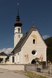
Worth seeing in Pettnau are the St. Georgskirche, which has been built in 1090 and the Mellaunerhof, the oldest inn in the Tyrol, as well as the sculpture garden of Bernhard Witsch.
References
External links
Wikimedia Commons has media related to Pettnau.
- v
- t
- e
Municipalities in the district of Innsbruck-Land
- Absam
- Aldrans
- Ampass
- Axams
- Baumkirchen
- Birgitz
- Ellbögen
- Flaurling
- Fritzens
- Fulpmes
- Gnadenwald
- Götzens
- Gries am Brenner
- Gries im Sellrain
- Grinzens
- Gschnitz
- Hall in Tirol
- Hatting
- Inzing
- Kematen in Tirol
- Kolsass
- Kolsassberg
- Lans
- Leutasch
- Matrei am Brenner
- Mieders
- Mils
- Mutters
- Natters
- Navis
- Neustift im Stubaital
- Oberhofen im Inntal
- Obernberg am Brenner
- Oberperfuss
- Patsch
- Pettnau
- Pfaffenhofen
- Polling in Tirol
- Ranggen
- Reith bei Seefeld
- Rinn
- Rum
- St. Sigmund im Sellrain
- Scharnitz
- Schmirn
- Schönberg im Stubaital
- Seefeld in Tirol
- Sellrain
- Sistrans
- Steinach am Brenner
- Telfes
- Telfs
- Thaur
- Trins
- Tulfes
- Unterperfuss
- Vals
- Volders
- Völs
- Wattenberg
- Wattens
- Wildermieming
- Zirl

Authority control databases | |
|---|---|
| International |
|
| National |
|
 | This Tyrol location article is a stub. You can help Wikipedia by expanding it. |
- v
- t
- e


