Rödinghausen
Municipality in North Rhine-Westphalia, Germany
Flag

Coat of arms
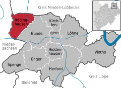
Location of Rödinghausen within Herford district
(2020–25) Siegfried Lux[1] (SPD)
(2023-12-31)[2]
32289
05226 (Bruchmühlen, southeast),
05223 (Bünde, southwest)
Rödinghausen is a municipality in the district of Herford, in North Rhine-Westphalia, Germany.
Geography
Rödinghausen is situated on the southern slope of the Wiehengebirge, approx. 20 km north-west of Herford and 25 km north of Bielefeld.
Neighbouring municipalities
- Bünde
- Melle
- Preußisch Oldendorf
- Hüllhorst
Division of the municipality

Rödinghausen consists of 5 villages:
- Bieren (1,299 inhabitants)
- Bruchmühlen (3,378 inhabitants); (named Westkilver until 1969)
- Ostkilver (1,876 inhabitants)
- Rödinghausen (1,644 inhabitants)
- Schwenningdorf (2,356 inhabitants)
Mayors
- since 2020: Siegfried Lux (SPD)
- 2004–2020: Ernst-Wilhelm Vortmeyer (* 1954) (SPD)
- 1999-2004: Kurt Vogt (SPD)
- 1969-1998: Günter Oberpenning (SPD)
References
- ^ Wahlergebnisse in NRW Kommunalwahlen 2020, Land Nordrhein-Westfalen, accessed 21 June 2021.
- ^ "Bevölkerung der Gemeinden Nordrhein-Westfalens am 31. Dezember 2023 – Fortschreibung des Bevölkerungsstandes auf Basis des Zensus vom 9. Mai 2011" (in German). Landesbetrieb Information und Technik NRW. Retrieved 2024-06-20.
External links
![]() Media related to Rödinghausen at Wikimedia Commons
Media related to Rödinghausen at Wikimedia Commons
- Official site (in German)
- v
- t
- e
Towns and municipalities in Herford (district)
- Bünde
- Enger
- Herford
- Hiddenhausen
- Kirchlengern
- Löhne
- Rödinghausen
- Spenge
- Vlotho

Authority control databases | |
|---|---|
| International |
|
| National |
|
| This Herford district location article is a stub. You can help Wikipedia by expanding it. |
- v
- t
- e


