Registered historic parks and gardens in Torfaen
List of buildings in county borough of Wales

Map all coordinates using OpenStreetMap
Download coordinates as:
- KML
- GPX (all coordinates)
- GPX (primary coordinates)
- GPX (secondary coordinates)
Torfaen is a county borough in south-east Wales. It covers an area of 126 km2 (49 sq mi). In 2021 the population was approximately 92,300.
The Cadw/ICOMOS Register of Parks and Gardens of Special Historic Interest in Wales was established in 2002 and given statutory status in 2022. It is administered by Cadw, the historic environment agency of the Welsh Government.[1][2] Elisabeth Whittle described Cadw as having a "somewhat special and guiding role" in the preservation of historic parks and gardens, since they are "an integral part of Welsh archaeological and architectural heritage".[3] The register includes just under 400 sites, ranging from gardens of private houses, to cemeteries and public parks. Parks and gardens are listed at one of three grades, matching the grading system used for listed buildings. Grade I is the highest grade, for sites of exceptional interest; Grade II*, the next highest, denotes parks and gardens of great quality; while Grade II denotes sites of special interest.[4]
There are two registered parks and gardens in Torfaen County Borough, Pontypool Park and Llantarnam Abbey. The former is listed at Grade II* and the latter at Grade II.
Key
| Grade | Criteria[4] |
|---|---|
| I | Parks and gardens of exceptional interest |
| II* | Parks and gardens of great quality |
| II | Parks and gardens of special interest |
List of parks and gardens
| Name | Location Grid Ref.[note 1] Geo-coordinates | Date Listed | Description / Notes | Grade | Reference Number | Image |
|---|---|---|---|---|---|---|
| Pontypool Park | Pontypool SO283010 51°42′14″N 3°02′20″W / 51.7039°N 3.0389°W / 51.7039; -3.0389 (Pontypool Park) | 1 February 2022 | Park and country house garden[5] | II* | PGW(Gt)26(TOR) | 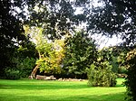 |
| Llantarnam Abbey | Llantarnam ST311929 51°37′51″N 2°59′46″W / 51.6308°N 2.9961°W / 51.6308; -2.9961 (Llantarnam Abbey) | 1 February 2022 | Country house garden[6] | II | PGW(Gt)25(TOR) |  |
See also
 Wales portal

- List of scheduled monuments in Torfaen
- Grade I listed buildings in Torfaen
- Grade II* listed buildings in Torfaen
Notes
- ^ Sometimes known as OSGB36, the grid reference is based on the British national grid reference system used by the Ordnance Survey.
References
- ^ "Historic Parks and Gardens". Cadw. Archived from the original on 9 March 2012.
- ^ "Registered historic parks and gardens". Cadw. Retrieved 19 February 2023.
- ^ Whittle 1992, p. 6.
- ^ a b "Understanding registered historic parks & gardens: 2. What is registration?". Cadw. Retrieved 3 April 2023.
- ^ Cadw. "Pontypool Park (PGW(Gt)26(TOR))". National Historic Assets of Wales. Retrieved 8 August 2023.
- ^ Cadw. "Llantarnam Abbey (PGW(Gt)25(TOR))". National Historic Assets of Wales. Retrieved 8 August 2023.
Sources
- Whittle, Elisabeth (1992). The Historic Gardens of Wales. Cardiff: CADW. ISBN 9780117015784.
- v
- t
- e
 Wales
Wales
| ||
|---|---|---|
| Principal settlements | 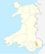 | |
| Electoral wards | ||
| Communities | ||
| Places of interest | ||
| Rivers and canals | ||
| Topics |
| |
| ||


