Reineskarvet
Mountain in Norway
60°46′42″N 8°9′57″E / 60.77833°N 8.16583°E / 60.77833; 8.16583
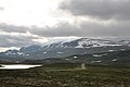
Reineskarvet is a significant mountain in the municipality of Ål in Buskerud, Norway.[2]
It is located in the Skarvheimen highland area between Jotunheimen and Hardangervidda, on the north side of Hallingdalen, west of Hemsedal. Reineskarvet looks like Hallingskarvet and lies parallel to it a bit farther north east. The highest point lies in the western end, while there is a summit in the eastern end with elevation 1732 m, popular for hiking.[3]
Gallery


References
- v
- t
- e


