Romeo Historic District
Historic district in Michigan, United States
United States historic place
Romeo Historic District | |
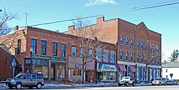 100 block of North Main Street, west side | |
42°48′7″N 83°0′51″W / 42.80194°N 83.01417°W / 42.80194; -83.01417 | |
| NRHP reference No. | 70000281[1] |
|---|---|
| Significant dates | |
| Added to NRHP | July 8, 1970 |
| Designated MSHS | April 24, 1970[2] |
The Romeo Historic District is a historic district roughly bounded by the corporate lines of Romeo, Michigan. It was listed on the National Register of Historic Places in 1970[1] and designated a Michigan State Historic Site in 1970.[2]
History
The area around Romeo was first settled in 1821, and in 1822 the first building was constructed in what was then known as "Hoxie's Settlement."[3] The first piece of the present-day village, extending two blocks in each direction from the corner of St. Claire and Main Streets, was platted by Col. John B. Hollister in 1830.[4] By 1837 a number of simple log farmhouses dotted the area, and the settlement boasted over 200 people, 34 houses,[4] three dry goods stores, a wagon shop, tannery, shoe shops, a foundry, a cooper shop, carpenter shop and a hoopskirt factory.[3] Hoxie's Settlement was incorporated as the village of Romeo in 1838.[3] The University of Michigan established a branch campus, the Romeo Academy, in the area in the 1840, attracting more prosperous academics and professionals to the area.[2] A railroad was laid through the village in 1869, bringing increased trade. Planned growth has allowed the Romeo community to maintain a high degree of historic integrity.[2]
Description
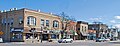
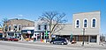
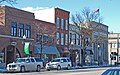
The Romeo Historic District contains approximately 100 well-preserved historic structures, constructed in a variety of architectural styles. Most are frame structures, including a number of Gothic Revival cottages, but the district also includes substantial brick buildings located along Romeo's main street.[2]
Romeo Images
|
|---|


References
- ^ a b "National Register Information System". National Register of Historic Places. National Park Service. March 13, 2009.
- ^ a b c d e "Romeo Historic District". Michigan State Housing Development Authority: Historic Sites Online. Archived from the original on June 4, 2012. Retrieved August 9, 2011.
- ^ a b c "About the Village of Romeo". Village of Romeo. Archived from the original on July 12, 2011. Retrieved August 9, 2011.
- ^ a b "Rome Reconnaissance Survey, chapter 3.2: Romeo". Romeo Downtown Development Authority. Archived from the original on March 31, 2012. Retrieved August 10, 2011.
Wikimedia Commons has media related to Romeo Historic District.
- v
- t
- e
- Architectural style categories
- Contributing property
- Historic district
- History of the National Register of Historic Places
- Keeper of the Register
- National Park Service
- Property types
- List of U.S. National Historic Landmarks by state:
- Alabama
- Alaska
- Arizona
- Arkansas
- California
- Colorado
- Connecticut
- Delaware
- Florida
- Georgia
- Hawaii
- Idaho
- Illinois
- Indiana
- Iowa
- Kansas
- Kentucky
- Louisiana
- Maine
- Maryland
- Massachusetts
- Michigan
- Minnesota
- Mississippi
- Missouri
- Montana
- Nebraska
- Nevada
- New Hampshire
- New Jersey
- New Mexico
- New York
- North Carolina
- North Dakota
- Ohio
- Oklahoma
- Oregon
- Pennsylvania
- Rhode Island
- South Carolina
- South Dakota
- Tennessee
- Texas
- Utah
- Vermont
- Virginia
- Washington
- West Virginia
- Wisconsin
- Wyoming
 National Register of Historic Places portal
 Category


