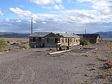
Sodaville, Nevada
Ghost town in Nevada, United States
38°20′28″N 118°06′10″W / 38.34111°N 118.10278°W / 38.34111; -118.10278[2][2]
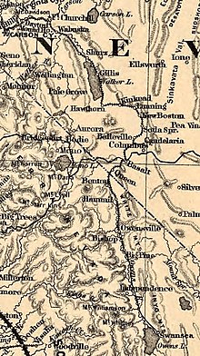
Sodaville is an extinct town in Mineral County, in the U.S. state of Nevada. The GNIS classifies it as a populated place.[2]
History
A variant name was "Soda Springs".[2] A post office called Sodaville was established in 1882, and remained in operation until 1917.[3]
Initially, a railroad station was intended to be at Sodaville, but an agreement between the railroad and land speculators could not be reached, so Mina, Nevada was platted two miles north of Sodaville.[4]
See also
- Thenardite, a sodium sulfate mineral, Na2SO4, found at Sodaville
References
- ^ Federal Writers' Project (1941). Origin of Place Names: Nevada (PDF). W.P.A. p. 53.
- ^ a b c d U.S. Geological Survey Geographic Names Information System: Sodaville
- ^ U.S. Geological Survey Geographic Names Information System: Sodaville Post Office (historical)
- ^ Earl, Phillip I. (1988-01-03). "2 Nevada towns' existence linked to greedy land speculators". Reno Gazette-Journal. p. 38. Retrieved 2018-08-09 – via Newspapers.com.


External links
- Sodaville ghost town
- v
- t
- e
Municipalities and communities of Mineral County, Nevada, United States
County seat: Hawthorne
- Hawthorne
- Mina
- Schurz
- Walker Lake
community
- Luning
- Nevada portal
- United States portal
| Authority control databases: National |
|
|---|
 | This Mineral County, Nevada state location article is a stub. You can help Wikipedia by expanding it. |
- v
- t
- e


