Swangey Fen, Attleborough
Site of Special Scientific Interest in Attleborough, Norfolk, England
| Site of Special Scientific Interest | |
 | |
| Location | Norfolk |
|---|---|
| Grid reference | TM 013 931[1] |
| Interest | Biological |
| Area | 48.4 hectares (120 acres)[1] |
| Notification | 1984[1] |
| Location map | Magic Map |
Swangey Fen, Attleborough is a 48.4-hectare (120-acre) biological Site of Special Scientific Interest south-west of Attleborough in Norfolk.[1][2] It is part of the Norfolk Valley Fens Special Area of Conservation.[3]
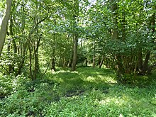
Part of this site is spring fed fen with diverse flora, including grass of Parnassus, marsh helleborine and several rare mosses. The fen is surrounded by wet woodland and grassland.[4]
Much of this site is private but there is public access to an area formerly managed by the Norfolk Wildlife Trust off Fen Street
Wikimedia Commons has media related to Swangey Fen.
References
- ^ a b c d "Designated Sites View: Swangey Fen, Attleborough". Sites of Special Scientific Interest. Natural England. Retrieved 22 July 2018.
- ^ "Map of Swangey Fen, Attleborough". Sites of Special Scientific Interest. Natural England. Retrieved 22 July 2018.
- ^ "Designated Sites View: Norfolk Valley Fens". Special Areas of Conservation. Natural England. Retrieved 25 May 2018.
- ^ "Swangey Fen, Attleborough citation". Sites of Special Scientific Interest. Natural England. Retrieved 22 July 2018.
52°29′56″N 0°57′50″E / 52.499°N 0.964°E / 52.499; 0.964
- v
- t
- e
- Alderfen Broad
- Alderford Common
- Ant Broads and Marshes
- Aslacton Parish Land
- Badley Moor
- Barnham Cross Common
- Beeston Cliffs
- Beetley and Hoe Meadows
- Blo' Norton and Thelnetham Fens
- Booton Common
- Boughton Fen
- Breckland Farmland
- Breckland Forest
- Breydon Water
- Bridgham and Brettenham Heaths
- The Brinks, Northwold
- Broad Fen, Dilham
- Bryant's Heath, Felmingham
- Bure Broads and Marshes
- Burgh Common and Muckfleet Marshes
- Buxton Heath
- Calthorpe Broad
- Cantley Marshes
- Castle Acre Common
- Cawston and Marsham Heaths
- Cockthorpe Common, Stiffkey
- Coston Fen, Runhall
- Cranberry Rough, Hockham
- Cranwich Camp
- Crostwick Marsh
- Damgate Marshes, Acle
- Decoy Carr, Acle
- Dereham Rush Meadow
- Dersingham Bog
- Didlington Park Lakes
- Dillington Carr
- Ducan's Marsh
- East Harling Common
- East Ruston Common
- East Walton and Adcock's Common
- East Winch Common
- East Wretham Heath
- Eaton Chalk Pit
- Edgefield Little Wood
- Elm Road Field, Thetford
- Felbrigg Woods
- Field Barn Heaths, Hilborough
- Flordon Common
- Forncett Meadows
- Foulden Common
- Foxley Wood
- Fritton Common, Morningthorpe
- Gawdyhall Big Wood, Harleston
- Geldeston Meadows
- Great Cressingham Fen
- Great Yarmouth North Denes
- Grime's Graves
- Gunton Park Lake
- Hall Farm Fen, Hemsby
- Halvergate Marshes
- Hardley Flood
- Hedenham Wood
- Hilgay Heronry
- Hockering Wood
- Holly Farm Meadow, Wendling
- Holt Lowes
- Honeypot Wood
- Hooks Well Meadows, Great Cressingham
- Horningtoft Wood
- Horse Wood, Mileham
- Hunstanton Cliffs
- Islington Heronry
- Kelling Heath
- Kenninghall and Banham Fens with Quidenham Mere
- Leziate, Sugar and Derby Fens
- Limpenhoe Meadows
- Lower Wood, Ashwellthorpe
- Ludham - Potter Heigham Marshes
- Mattishall Moor
- Middle Harling Fen
- Narborough Railway Embankment
- New Buckenham Common
- North Norfolk Coast
- Old Bodney Camp
- Old Buckenham Fen
- Ouse Washes
- Overstrand Cliffs
- Paston Great Barn
- Poplar Farm Meadows, Langley
- Potter and Scarning Fens, East Dereham
- Potter's Carr, Cranworth
- Priory Meadows, Hickling
- Pulham Market Big Wood
- Redgrave and Lopham Fens
- Ringstead Downs
- River Nar
- River Wensum
- Rosie Curston's Meadow, Mattishall
- Roydon Common
- Scoulton Mere
- Sea Mere, Hingham
- Sexton Wood
- Shallam Dyke Marshes, Thurne
- Shelfanger Meadows
- Sheringham and Beeston Regis Commons
- Shotesham Common
- Shotesham-Woodton Hornbeam Woods
- Sidestrand and Trimingham Cliffs
- Smallburgh Fen
- Snettisham Carstone Quarry
- Southrepps Common
- Stanford Training Area
- Stanley and Alder Carrs, Aldeby
- Stiffkey Valley
- Swangey Fen, Attleborough
- Swannington Upgate Common
- Swanton Novers Woods
- Sweetbriar Road Meadows, Norwich
- Syderstone Common
- Thetford Golf Course and Marsh
- Thompson Water, Carr and Common
- Tindall Wood, Ditchingham
- Trinity Broads
- Upper Thurne Broads and Marshes
- Upton Broad and Marshes
- Warham Camp
- The Wash
- Wayland Wood, Watton
- Weeting Heath
- Wells Chalk Pit
- Westwick Lakes
- Weybourne Cliffs
- Whitwell Common
- Winterton-Horsey Dunes
- Wiveton Downs
- Wretham Park Meres
- Yare Broads and Marshes
- Bawsey
- Beeston Cliffs
- Bilsey Hill
- Blackborough End Pit
- Bramerton Pits
- Breckland Forest
- Briton's Lane Gravel Pit
- Broome Heath Pit
- Caistor St Edmund Chalk Pit
- Catton Grove Chalk Pit
- Cranberry Rough, Hockham
- Dersingham Bog
- East Runton Cliffs
- East Walton and Adcock's Common
- Glandford (Hurdle Lane)
- Glandford (Letheringsett Road)
- Gooderstone Warren
- Grime's Graves
- Grimston Warren Pit
- Happisburgh Cliffs
- Heacham Brick Pit
- Holkham Brick Pit
- Hunstanton Cliffs
- Hunstanton Park Esker
- Leet Hill, Kirby Cane
- Morston Cliff
- Mundesley Cliffs
- North Norfolk Coast
- Overstrand Cliffs
- Setchey
- Sidestrand and Trimingham Cliffs
- St James' Pit
- Stanford Training Area
- Wells Chalk Pit
- West Runton Cliffs
- Weybourne Cliffs
- Weybourne Town Pit
- Wiggenhall St Germans
- Winterton-Horsey Dunes
- Wiveton Downs
- Wretton


