Szigetköz
Largest island of Hungary
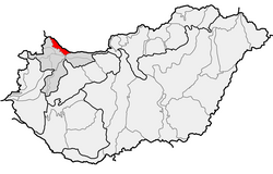

The Szigetköz (literally "island alley"; German: Kleine Schüttinsel, lit. 'Little Schütt Island'; Slovak: Malý Žitný ostrov, lit. 'Little Rye Island') is an island on the Danube in Western Hungary, part of the Little Hungarian Plain. It is the largest island in Hungary, with an area of 375 square kilometres (145 square miles).[1] The territory's elevation varies between 110 and 125 metres (361 and 410 feet) above sea level.[citation needed]
See also
- Geography of Hungary
- Little Hungarian Plain
- Žitný ostrov
References
- ^ Fitch, Chris (2017). "Down the Danube: Pack riding". Geographical. 89 (11): 57–60.
- "Schütt" . Collier's New Encyclopedia. 1921.
- "Schütt" . New International Encyclopedia. 1905.
- v
- t
- e
Geographical regions of Hungary
- Alpokalja
- Kőszeg Mountains
- Sopron Mountains
- Vas Hills
- Balfi Hills

- Hanság
- Fertőzug
- Neusiedl Basin
- Rábaköz
- Szigetköz
- Marcal Basin
- Moson Plain
- Komárom-Esztergom Plain
- Baranya
- Zala Hills
- Inner Somogy
- Outer Somogy
- Zselic
- Völgység
- Szekszárd Hills
- Baranya Hills
- Villány Mountains
- Keszthely Mountains
- Tapolca Basin
- Balaton Uplands
- Bakony
- Bakonyalja
- Sokoró
- Vértesalja
- Velence Hills
- Gerecse Mountains
- Buda Hills
- Pilis Mountains
- Visegrád Mountains
- Vértes Mountains
- Mecsek
- Outer Somogy
- Inner Somogy
- Tolna-Baranya Hills
- Balaton Basin
Mountains
Authority control databases | |
|---|---|
| International |
|
| National |
|
47°51′N 17°27′E / 47.85°N 17.45°E / 47.85; 17.45
 | This Hungarian geography article is a stub. You can help Wikipedia by expanding it. |
- v
- t
- e


