Thamewali
Town and union council in Punjab, Pakistan
Thamewali تھمےوالی | |
|---|---|
Town and union council | |
| Thamewali | |
 | |
| Coordinates: 32°47′06″N 71°46′49″W / 32.78500°N 71.78028°W / 32.78500; -71.78028 | |
| Country | Pakistan |
| Region | Punjab |
| District | Mianwali District |
| Elevation | 448 m (1,470 ft) |
| Time zone | UTC+5 (PST) |


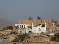
Thamewali is a town and union council of Mianwali District in the Punjab province of Pakistan. It is part of Mianwali Tehsil and is at 32°47'6N 71°46'49E and has an altitude of 448 m (1,470 ft).
History
After the partition of India and Pakistan in 1947 Hindus left the area. In 2009 the Pakistani army began occupying the area to for nuclear weapon storage.[1]
Geography
Thamewali has salt range mountains on the west side of the village. There is a fort on top of the mountain
References
- ^ "Pakistan building nuclear weapons storage unit deep in the mountains". 10 October 2017.
- "ملک محمد اکرم کے جیتنے کے بعد خوشیوں کے مناظر". Retrieved 14 December 2016 – via Thamewali.wordpress.com.
- "تھمےوالی ،ملک محمد اکرم کے جلسے کی تصویری جھلکیاں". 14 December 2016 – via Thamewali.wordpress.com.
- تھمےوالی ،بنیادی مرکزی صحت کا کچھ تعارف، ضرور پڑھیں
- تھمےوالی ،وڈے کھو پر بوھڑ کے درخت کے بارے میں دلچسپ معلومات، ضرور پڑھیں
- واٹر سپلائی سکیم تھمےوالی کی تاریخ پر مبنی ایک خوبصورت مضمون، ضرور پڑھیں
- ملک محمداکرم اعوان (یوسی) تھمےوالی کی زندگی پر ایک مضمون پڑھئے
- صوبے والے بن کے بارے میں تاریخی معلومات
- تھمےوالی میں موجود ایک پرانا کنواں”مٹھا چوئے” کے بارے میں جاننےکیلئے کلک کریں
Wikimedia Commons has media related to Thamewali.
- v
- t
- e
Administrative divisions of Mianwali District
- Mianwali
- Isakhel
- Mianwali
- Piplan
- Abbakhel
- Alluwali
- Ban Hafiz Jee
- Chakrala
- Chapri
- Chhidru
- Dabb Balouchan
- Daud Khel(Rural)
- Daood Khel (Town)
- Dher Umid Ali Shah
- Doaba
- Gujrat
- Gulmiri
- Hafiz Wala
- Hernoli(Rural)
- Harrnauli(Urban)
- Isakhel
- Kalabagh
- Kallur
- Kamar Mushani
- Kamar Mushani Pakka
- Khaglan Wala
- Khanqah Sirajia
- Kot Chandna
- Kundian-I
- Kundian-Ii
- Kundian Rural
- Mari
- Mianwali City -I
- Mianwali City -Ii
- Mianwali City -Iii
- Mianwali City -Iv
- Mochh
- Musakhel
- Muzafarpur Janubi
- Muzafarpur Shumali
- Namal
- Paikhel
- Piplan
- Qureshian
- Rokhri
- Shadia
- Shahbaz Khel
- Sultan Khel
- Swans
- Tabisar
- Tanikhel
- Thamewali
- Tibba Mehrban Shah
- Tola Bhangi Khel
- Trag
- Vanjari
- Vichvin Bala
- Wan Bhachran
- Watta Khel
- Yaru Khel
32°47′6″N 71°46′49″E / 32.78500°N 71.78028°E / 32.78500; 71.78028
 | This article about a location in Mianwali District, Punjab, Pakistan is a stub. You can help Wikipedia by expanding it. |
- v
- t
- e


