Trauttmansdorff Castle
You can help expand this article with text translated from the corresponding article in German. (October 2017) Click [show] for important translation instructions.
- View a machine-translated version of the German article.
- Machine translation, like DeepL or Google Translate, is a useful starting point for translations, but translators must revise errors as necessary and confirm that the translation is accurate, rather than simply copy-pasting machine-translated text into the English Wikipedia.
- Do not translate text that appears unreliable or low-quality. If possible, verify the text with references provided in the foreign-language article.
- You must provide copyright attribution in the edit summary accompanying your translation by providing an interlanguage link to the source of your translation. A model attribution edit summary is
Content in this edit is translated from the existing German Wikipedia article at [[:de:Schloss Trauttmansdorff]]; see its history for attribution. - You may also add the template
{{Translated|de|Schloss Trauttmansdorff}}to the talk page. - For more guidance, see Wikipedia:Translation.
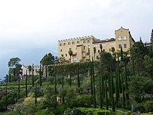
Trauttmansdorff Castle is a castle located south of the city of Merano, South Tyrol, northern Italy. Since 1543, the castle and gardens were owned by the House of Trauttamandsorff, one of the oldest and most distinguished Austrian noble families.[1] It is home to the Touriseum, a museum of tourism[2] and since 2001 the surrounding grounds have been open as the Trauttmansdorff Castle Gardens, a botanical garden.
During the years of fascist Italy the castle was called di Nova Castle (Torrente Nova is the name of a little brook near Trauttmansdorff).
References
External links
![]() Media related to Trauttmansdorff Castle at Wikimedia Commons
Media related to Trauttmansdorff Castle at Wikimedia Commons
46°39′39″N 11°11′07″E / 46.66083°N 11.18528°E / 46.66083; 11.18528
Authority control databases | |
|---|---|
| International |
|
| National |
|
- v
- t
- e


