Tropical Storm Marco was the smallest tropical cyclone on record by radius of winds from its center.[1] The thirteenth named storm of the 2008 Atlantic hurricane season, Marco developed out of a broad area of low pressure over the northwestern Caribbean during late September 2008. Influenced by a tropical wave on October 4, a small low-level circulation center developed over Belize. After crossing the southern end of the Yucatán Peninsula and emerging into the Bay of Campeche, the low was declared Tropical Depression Thirteen early on October 6. The depression quickly intensified into a tropical storm and was given the name Marco later that day. Marco reached its peak intensity with winds of 65 mph (100 km/h) early on October 7. Around this time, tropical storm force winds extended 11.5 miles (18.5 km) from the center of the storm, making Marco the smallest tropical cyclone on record.[2][1] Around 1200 UTC, Marco made landfall near Misantla, Veracruz. The storm rapidly weakened after landfall, dissipating later that day.
Due to its small size, Marco caused minimal damage; however, the storm's heavy rains led to floods up to 10 feet (3.05 m) deep that covered highways and damaged homes.
Extratropical cyclone, remnant low, tropical disturbance, or monsoon depression
Tropical Storm Marco originated in a broad area of low pressure that persisted over the northwestern Caribbean in early October, 2008. On October 4, a tropical wave reached the same area, and the system spawned a circulation center over Belize. Development of the low was initially inhibited by its proximity to land. As the system neared the Bay of Campeche, convection quickly developed around the low. At 00:00 UTC on October 6, the low was designated as Tropical Depression Thirteen while located over Laguna de Términos.[1] A mid-level ridge located to the north of the depression led to movement in a general west-northwest direction. Forecasters anticipated intensification up until landfall because of the storm's well-developed outflow and the low wind shear and high sea surface temperatures in its path.[3] By 12:00 UTC, the small cyclone, with a cloud shield no more than 85 miles (137 kilometers) across, was upgraded to Tropical Storm Marco.[1]
Favorable conditions for development allowed Marco to quickly intensify throughout the day on October 6. Early on October 7, Marco reached its peak intensity with winds of 65 mph (105 km/h) and a minimum pressure of 998 millibar (hPa; 29.47 inHg).[1] This was based on a reconnaissance mission into Marco which recorded flight-level winds of 70 mph (110 km/h), corresponding to a surface wind speed of 61 mph (98 km/h). Following the quick increase in intensity, forecasters noted the possibility of Marco intensifying into a hurricane before making landfall.[4] The storm maintained a small area of deep convection, averaging 9.2 miles (14.8 km) in diameter, as it continued moving towards the west-northwest.[5] Shortly after reaching peak intensity, tropical storm force winds extended 11.5 miles (18.5 km) from the center of Marco.[6] At 12:00 UTC, the center of Marco made landfall near Misantla, Veracruz, with winds of 65 mph (105 km/h).[1] Once inland, Marco rapidly weakened,[7] being downgraded to a tropical depression six hours after landfall. The small depression dissipated later that day over the mountains of Mexico.[1]
Preparations, impact, and records
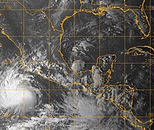
Tropical Storms Marco (center), Norbert (bottom left), and the low that would eventually become Odile (bottom) on October 6.
Upon the storm's formation, the Government of Mexico issued a tropical storm warning for the Gulf of Mexico from Tuxpan to Punta El Lagarto.[8] That afternoon the government issued a hurricane watch between Cabo Rojo and Veracruz, and extended the tropical storm warning northward to Cabo Rojo.[9] Officials closed schools ahead of the storm and opened 200 shelters.[10] An estimated 3,000 people were evacuated from low-lying areas along the coast.[11] Soldiers used school buses to transport evacuees to the shelters.[10] Marco formed in the area of Mexico's main oil-facilities,[12] leading to the evacuation of 33 workers from four platforms. Six oil wells and a natural gas processing plant were also shut down in Veracruz. The Mexican Secretariat of Communications and Transportation also closed the ports of Nautla and Alvarado to small vessels as a precautionary measure.[10]
Marco shortly after being upgraded to a tropical storm on October 6
Upon landfall, heavy rains peaking at 7.9 inches (201 millimeters) in El Pujal, San Luis Potosí[13] and falling at rates up to 1 inch per hour (25.4 mm/h),[1] caused some flooding in coastal towns near Veracruz as people evacuated to higher ground.[14] The rains from Marco worsened flood situations in areas of Mexico already suffering from severe flooding.[10] Officials in Veracruz, in their post-storm damage survey, reported that two rivers, the Quilate and Tenoch, overflowed their banks due to rains produced by Marco.[15] One of these rivers left the towns of Minatitlan and Hidalgotitlan under 10 ft (3 m) of water.[10] Highways along the coast of Veracruz were also flooded.[16] Another 250 homes were flooded when a lake and a river overflowed their banks.[17] Thirteen municipalities within Veracruz were affected by Marco. In Vega de Alatorre, 77 people were evacuated to nearby shelters after their homes were inundated with water. Three landslides were also reported in Misantla Colipa; none of them caused damage.[18] In all, Marco's impact was light; minimal damage was recorded, and none of the estimated 400,000 people affected by the storm sustained injury.[1][19]
In the wake of Marco, the General Coordination of Civil Protection of the Ministry of the Interior declared a state of emergency for 48 municipalities in Veracruz.[20][21][22] Relief goods were distributed to the affected areas by October 9. The Government of Mexico reported that 4,700 blankets, 2,900 mattresses, 5,554 bottles of water (each containing 500 milliliters), 260,000 boxes of milk, 250,000 packages of biscuits, and 12,400 boxes of school supplies had been distributed.[23]
At 0052 UTC on October 7, tropical storm force winds extended 11.5 miles (18.5 km) from the center of Marco. This made Marco the smallest tropical cyclone ever recorded, surpassing the previous record set on December 24, 1974 by Cyclone Tracy, whose tropical storm-force winds extended 30 miles (48 km).[2][1][24]
Cyclone Tracy – Previous record holder for the smallest tropical cyclone
References
^ abcdefghijJames L. Franklin (November 4, 2008). "Tropical Cyclone Report: Tropical Storm Marco" (PDF). National Hurricane Center. Retrieved January 23, 2009.
^ abNeal Dorst (May 29, 2009). "Subject: E5) Which are the largest and smallest tropical cyclones on record?". National Hurricane Center. Archived from the original on December 22, 2008. Retrieved May 29, 2009.
^Richard J. Pasch; Jamie Rhome (October 6, 2008). "Tropical Depression Thirteen Discussion One". National Hurricane Center. Retrieved January 23, 2009.
^Richard J. Pasch; Jamie Rhome (October 6, 2008). "Tropical Storm Marco Discussion Two". National Hurricane Center. Retrieved January 23, 2009.
^Stacy R. Stewart (October 7, 2008). "Tropical Storm Marco Discussion Three". National Hurricane Center. Retrieved January 23, 2009.
^Richard J. Pasch; Jamie Rhome (October 7, 2008). "Tropical Storm Marco Discussion Five". National Hurricane Center. Retrieved January 23, 2009.
^Richard J. Pasch; Jamie Rhome (October 7, 2008). "Tropical Depression Marco Discussion Six". National Hurricane Center. Retrieved January 23, 2009.
^Richard J. Pasch; Jamie Rhome (October 6, 2008). "Tropical Depression Thirteen Public Advisory One". National Hurricane Center. Retrieved January 23, 2009.
^Richard J. Pasch; Jamie Rhome (October 6, 2008). "Tropical Storm Marco Public Advisory Two". National Hurricane Center. Retrieved January 23, 2009.
^ abcde"Tropical Storm Marco hits Mexico's Gulf coast". USA Today. Associated Press. October 7, 2008. Retrieved January 23, 2009.
^"Tropical Storm Marco hits Mexico's Gulf coast". NBC News. Associated Press. October 8, 2008. Retrieved January 23, 2009.
^Robert Campbell (October 6, 2008). "Tropical storm Marco forms near Mexico oil fields". Reuters. Retrieved October 8, 2008.
^"41st Session Country Report: Mexico" (in Spanish). World Meteorological Organization. 2009. Retrieved March 9, 2009.
^"Tropical Storm Marco lashes Mexico's Gulf coast". Reuters. October 7, 2008. Archived from the original on August 15, 2009. Retrieved October 8, 2008.
^"Press Release" (Press release) (in Spanish). Government of Veracruz. October 7, 2008. Archived from the original on August 15, 2009. Retrieved June 2, 2009.
^Adventist Development and Relief Agency International (October 10, 2008). "Mexico: Heavy rains flood Tabasco and Veracruz, ADRA responds". ReliefWeb. Archived from the original on December 12, 2012. Retrieved January 23, 2009.
^A. Timoteo, R. Villalba, R. López, S. Ocampo, M. Habana, S. Maldonado y E. Argüelles (October 9, 2008). "Veracruz: causa Marco inundaciones y crecidas de ríos en 14 municipios". La Jornada (in Spanish). Retrieved January 24, 2009.{{cite web}}: CS1 maint: multiple names: authors list (link)
^"Tormenta "Marcos" afecta 13 municipios de Veracruz" (in Spanish). Millennium Publishing Group. Notimex. October 7, 2008. Archived from the original on October 11, 2008. Retrieved June 2, 2009.
^"Tropical Storm Marco hits Mexican coast, 2,000 people evacuated". Tehran Times. Chinaview. October 9, 2008. Retrieved January 5, 2020.
^"Causa graves daños tormenta "Marco" en Veracruz". El Siglo de Torreón (in Spanish). Notimex en Xalapa. October 8, 2008. Retrieved May 17, 2009.
^"Solicita Veracruz declaratoria de emergencia para 14 municipios". Revista Fundamentos (in Spanish). October 8, 2008. Archived from the original on March 25, 2016. Retrieved May 17, 2009.
^Karla Cancino (November 11, 2008). "Flood, a Chronicle of Tragedy". ImagenDelGolfo.com.mx (in Spanish). Xalapa. Archived from the original on February 24, 2012. Retrieved June 2, 2009.
^"Continúa distribución de víveres a afectados por lluvias en Veracruz". La Crónica de Hoy (in Spanish). Notimex en Xalapa. October 9, 2008. Archived from the original on August 14, 2009. Retrieved May 17, 2009.


 Tropical cyclone
 Subtropical cyclone
 Extratropical cyclone, remnant low, tropical disturbance, or monsoon depression