Tsolo
‹ The template Infobox settlement is being considered for merging. ›
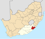
Place in Eastern Cape, South Africa
31°19′00″S 28°45′00″E / 31.316667°S 28.75°E / -31.316667; 28.75 (2011)[1]
5170
5170
Tsolo is a town in Mhlontlo Local Municipality in OR Tambo District of the Eastern Cape province of South Africa.
The town is some 42 km north-west of Mthatha and 22 km south-west of Qumbu. The name, derived from Xhosa, is said to mean ‘pointed’, referring to the shape of hills there.[2]
Tsolo has two government hospitals, St Lucy's Hospital and Dr. Malizo Mpehle Memorial Hospital.[3]
Notable people
- Kedibone Letlaka-Rennert – Miss Transkei 1981 and Diversity Advisor at the International Monetary Fund
- Masizole Mnqasela – Western Cape Provincial Parliament
- Zozibini Tunzi – Miss Universe 2019
- Mandisa Maya - Female jurist
- Ayanda Daweti - Actor
- Asenathi Makanya - Writer
References
- ^ a b c d "Main Place Tsolo". Census 2011.
- ^ "Dictionary of Southern African Place Names (Public Domain)". Human Science Research Council. p. 439.
- ^ Eastern Cape Dept of Health official website Archived 2014-03-30 at the Wayback Machine
- v
- t
- e
Municipalities and communities of OR Tambo District Municipality, Eastern Cape
District seat: Mthatha
- Qumbu
- Tsolo
 | This Eastern Cape location article is a stub. You can help Wikipedia by expanding it. |
- v
- t
- e


