Wami Taksar
Town in Musikot Municipality, Nepal
Wami Taksar वामीटक्सार Wamitaksar | |
|---|---|
Town | |
28°11′N 83°18′E / 28.183°N 83.300°E / 28.183; 83.300 | |
| Country |  Nepal Nepal |
| Municipality | Musikot Municipality |
| District | Gulmi District |
| Elevation | 872 m (2,861 ft) |
| Population (1991) | |
| • Total | 6,421 |
| Time zone | UTC+5:45 (Nepal Time) |
Wamitaksar (Nepali: वामीटक्सार) is a town in Gulmi District part of the Musikot Municipality. At the time of the 1991 Nepal census it had a population of 6421.[1] It serves as the headquarters of the Musikot Municipality.[2]
Gallery
- Landscapes and Climates of Wamitaksar
-
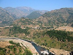 Badighat
 -
 People holding Flag of Nepal
 -
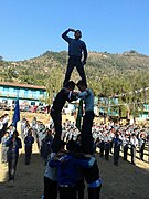 Salute to Mother Nepal


References
External links
- UN map of the municipalities of Gulmi District
- v
- t
- e
Gulmi District
Headquarter: Tamghas
- Musikot
- Resunga

- Aaglung
- Aapchaur
- Amar Abathok
- Amarpur
- Apchaur
- Arbani
- Arje
- Arkhawang
- Arlangkot
- Aslewa
- Badagaun
- Bajhketeri
- Baletaksar
- Balithum
- Bamgha
- Bami
- Bastu
- Bhanbhane
- Bharse
- Bhurmung
- Birbas
- Bisukharka
- Chhapahile
- Dalamchaur
- Darbar Devisthan
- Darling
- Daungha
- Dhamir
- Dhurkot Bastu
- Dhurkot Bhanbhane
- Dhurkot Nayagaun
- Dhurkot Rajasthal
- Digam
- Dirbung
- Dohali
- Foksing
- Gaudakot
- Gurukot Rajasthal
- Gwadha
- Gwadi
- Hadahade
- Hadinete
- Hansara
- Harewa
- Harmichaur
- Harrachaur
- Hasara
- Hastichaur
- Hawangdi
- Hunga
- Isma Rajasthal
- Jaisithok
- Jayakhani
- Johang
- Juniya
- Juvung
- Khadgakot
- Kharjyang
- Kurgha
- Limgha
- Malagiri
- Murtung
- Musikot
- Myal Pokhari
- Nayagaun
- Neta
- Palkikot
- Paralmi
- Paudi Amarahi
- Pipaldhara
- Purkot Daha
- Purtighat
- Reemuwa
- Resunga Municipality
- Rupakot
- Ruru
- Shantipur
- Siseni
- Thanpati
- Thulo Lumpek
- Turang
- Wagla
- Wamitaksar
 | This article about a location in Gulmi District, Nepal is a stub. You can help Wikipedia by expanding it. |
- v
- t
- e


