Wiwaxy Peak
Mountain in Yoho NP, BC, Canada


Wiwaxy Peaks

Wiwaxy Peaks
Wiwaxy Peaks is a 2,706-metre (8,878-foot) mountain near Lake O'Hara in Yoho National Park, in the Canadian Rockies of British Columbia, Canada. The Burgess Shale animal Wiwaxia corrugata is named after it. The nearest higher neighbor is Mount Huber, 1.7 km (1.1 mi) to the east.[1]
History
It was named in 1894 by Samuel E.S. Allen for the Stoney First Nations word for "windy".
The mountain's current name became official in 1924 when the Geographical Names Board of Canada approved its name.[2]
The first ascent of the mountain was made in 1951 by T. Church, D. Pullin, W. Roubenheimer, and T. Whalley.[1]
Geology
Wiwaxy Peaks is composed of sedimentary rock laid down during the Precambrian to Jurassic periods.[3] Formed in shallow seas, this sedimentary rock was pushed east and over the top of younger rock during the Laramide orogeny.[4]
Climate
Based on the Köppen climate classification, Wiwaxy Peaks is located in a subarctic climate zone with cold, snowy winters, and mild summers.[5] Temperatures can drop below −20 °C with wind chill factors below −30 °C. Precipitation runoff from the peaks drains into tributaries of the Kicking Horse River which is a tributary of the Columbia River.
Routes
- Grassi Ridge
Gallery
-
 Wiwaxy Peak, from the Lake O'Hara campground
 -
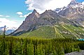 Wiwaxy Peaks and Huber
 -
 Wiwaxy Peaks
 -
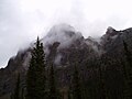 Wiwaxy Peak on a bad-weather morning


References
- ^ a b c d e "Wiwaxy Peaks". Bivouac.com. Retrieved 2018-11-17.
- ^ a b c "Wiwaxy Peaks". Geographical Names Data Base. Natural Resources Canada. Retrieved 2018-12-03.
- ^ Belyea, Helen R. (1960). The Story of the Mountains in Banff National Park (PDF). parkscanadahistory.com (Report). Ottawa: Geological Survey of Canada. Archived (PDF) from the original on 2015-10-02. Retrieved 2019-09-13.
- ^ Gadd, Ben (2008). Geology of the Rocky Mountains and Columbias.
- ^ Peel, M. C.; Finlayson, B. L.; McMahon, T. A. (2007). "Updated world map of the Köppen−Geiger climate classification". Hydrol. Earth Syst. Sci. 11: 1633–1644. ISSN 1027-5606.
External links
- "Wiwaxy Peak". BC Geographical Names.
- v
- t
- e
Places adjacent to Wiwaxy Peak
| Cathedral Mountain | Mount Victoria | |
 | ||
| Odaray Mountain |  Wiwaxy Peaks Wiwaxy Peaks | Mount Huber |
| Elizabeth Parker hut |  | Mount Lefroy |
| Lake O'Hara | Mount Hungabee |
 | This article about a location in British Columbia, Canada is a stub. You can help Wikipedia by expanding it. |
- v
- t
- e


