Woodruff Place, Indianapolis
United States historic place
Woodruff Place | |
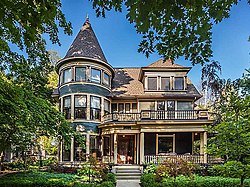 A private residence in Woodruff Place | |
39°46′40″N 86°7′42.5″W / 39.77778°N 86.128472°W / 39.77778; -86.128472 | |
| Architectural style | Late 19th and 20th Century Revivals, Late Victorian |
|---|---|
| NRHP reference No. | 72000012 [1] |
| Added to NRHP | July 31, 1972 |
Woodruff Place is a neighborhood in Indianapolis, Indiana, located about a mile east of downtown Indianapolis. It was established in the 1870s by developer James O. Woodruff as an early suburb of Indianapolis. Woodruff Place's boundaries are: 10th Street on the north, Woodruff Place West Drive on the west, Michigan Street on the south, and Woodruff Place East Drive on the east. Woodruff Place was incorporated in 1876 and remained an independent town even as the city of Indianapolis grew and expanded around it, enclosing the community well within the city limits. In1962 it became one of the final municipalities to be annexed by the city of Indianapolis prior to the merger of city and county governments under Unigov in 1969.
Woodruff Place is bounded on the west by the campus of Arsenal Technical High School, which opened in 1912 on the site of the former Indianapolis Arsenal and still uses several historic buildings from the arsenal.

Woodruff Place was once considered to be one of Indianapolis's more affluent neighborhoods before beginning a gradual decline as the automobile led to the development of newer upscale subdivisions starting in the late 1910s. By the 1950s, many of the grand homes had been subdivided into apartments. Previously, the neighborhood had only a modest collection of duplexes and smaller apartment buildings that had been added beginning in the early 1910s. The neighborhood reached its lowest point in the 1960s, prompting community organizing in the early 1970s to encourage neighborhood revitalization. The 1980s and 1990s saw extensive neighborhood rehabilitation, and Woodruff Place is now considered a highly desirable historic inner-city address.
Its design reflects the developer's plan to build a prestigious enclave. Most of the homes in Woodruff Place are expansive, Victorian style homes from the late 19th century. The layout of the neighborhood is simple; three drives that run north-south (appropriately named East, West, and Middle) and a cross drive (not surprisingly, named Cross Drive). The streets are lined with magnolia and oak trees and, except for Cross Drive, have central medians. A fountain sits at each one of the intersections. Smaller fountains line the medians.[2]
Woodruff Place was the inspiration behind Indianapolis native Booth Tarkington's successful novel The Magnificent Ambersons.[3][4] Artist T. C. Steele's son Brandt, a noted designer and architect in his own right, and his family were also Woodruff Place residents, living in a home designed by Brandt Steele.
James O. Woodruff also created "Hendricks Place". In the spring of 1872, Thomas A. Hendricks was elected governor of Indiana. He sold his property, the Bates-Hendricks House, to Woodruff, who then created his first Victorian neighborhood, Hendricks Place, surrounding the house. In the fall of that year, Woodruff created Woodruff Place, but few homes were built because a depression in 1873 stopped construction in both neighborhoods for almost twenty years.
In 1972, Woodruff Place was added to the National Register of Historic Places. In 2001, the neighborhood was officially designated a local historic preservation district by the city of Indianapolis.
References
- ^ "National Register Information System". National Register of Historic Places. National Park Service. March 15, 2006.
- ^ "Indiana State Historic Architectural and Archaeological Research Database (SHAARD)" (Searchable database). Department of Natural Resources, Division of Historic Preservation and Archaeology. Retrieved August 1, 2016. Note: This includes Nellie M. Coates (March 1972). "National Register of Historic Places Inventory Nomination Form: Woodruff Place Historic District" (PDF). Retrieved August 1, 2016., Site Map, and Accompanying photographs
- ^ V. F. Perkins. (August 2000). "The Magnificent Ambersons (book review)". University of Nottingham. Retrieved July 13, 2008.
Woodruff Place in Indianapolis, Indiana can't be found on a tourist map, but it would probably interest anyone who is familiar with Orson Welles's adaptation of Booth Tarkington's The Magnificent Ambersons
- ^ "Historic Districts". City of Indianapolis. Retrieved July 13, 2008.
Woodruff Place was the city's first "suburb" and was the setting for Booth Tarkington's Pulitzer Prize winning novel, The Magnificent Ambersons
External links
![]() Media related to Woodruff Place, Indianapolis at Wikimedia Commons
Media related to Woodruff Place, Indianapolis at Wikimedia Commons
- Woodruff Place Website
- Woodruff Place Apartments
- v
- t
- e
- Brendonwood
- Camp Edwin F. Glenn
- Central Court
- Chatham–Arch
- Cottage Home
- Cumberland
- Emerson Avenue Addition
- Fletcher Place
- Forest Hills
- Fort Benjamin Harrison (Boundary Increase)
- Garfield Drive
- Golden Hill
- Haughville
- Herron–Morton Place
- Holy Rosary–Danish Church
- Homecroft
- Indiana Avenue
- Indianapolis Union Station Wholesale District
- Irvington
- Irvington Terrace
- Laurel and Prospect
- Lockerbie Square (Boundary Increase)
- Massachusetts Avenue
- Meridian Park
- New Augusta
- North Meridian Street
- North Pennsylvania Street
- Northside
- North Irvington Gardens
- Old Northside
- Oliver Johnson's Woods
- P.R. Mallory Company Factory
- Ransom Place
- Riverside Drive
- St. Joseph Neighborhood
- St.Philip Neri Parish
- Shortridge–Meridian Street Apartments
- State and Prospect
- Town of Crows Nest
- Virginia Avenue
- Washington Park
- Washington Street–Monument Circle
- Watson Park
- Woodruff Place
- Allison Mansion
- Anderson–Thompson House
- Askren House
- Apple House
- Bals–Wocher House
- Bates–Hendricks House
- Benjamin Harrison Presidential Site
- Benton House
- Byram–Middleton House
- Campbell Mansion
- Cole House & 1925 Cole Brouette No. 70611
- Cotton–Ropkey House
- Flanner House Homes
- Fletcher House
- Glossbrenner Mansion
- Graham House
- Hanna–Ochler–Elder House
- Haverstick Farmstead
- Hill House
- Hollingsworth House
- Horner–Terrill House
- Hubbard House
- Jamieson–Bennett House
- Johnson–Denny House
- Julian–Clark House
- Kuhn House
- Levey Mansion
- Lustron House
- Mattison House
- Meier House
- Millikan House
- Moore House
- Morris–Butler House
- Nicholson–Rand House
- Oldfields
- Pierson–Griffiths House
- The Propylaeum (Schmidt House)
- Prosser House
- Recker House
- Riley House
- Schnull–Rauch House
- Sommer House
- Stewart Mansion
- Stumpf House
- Thompson House
- Tobey-Normington House
- Tomlinson House
- Wheeler–Stokely Mansion
Apartments
and Flats
- Alameda
- Alexandra
- Ambassador
- Baker
- Blacherne
- Burton
- Cathcart
- Chadwick
- Colonial
- Dartmouth
- Delaware Court
- Delaware Flats
- Devonshire
- Emelie
- Glencoe
- Grover
- Harriett
- Lodge
- Martens
- Massachusetts
- Mayleeno
- McKay
- Myrtle Fern
- Oxford
- Pennsylvania
- Plaza
- Rink
- Savoy
- Shelton
- Sid-Mar
- Spink
- Sylvania
- St. Clair
- Vienna
- Wil-Fra-Mar
- Wilson
- Wyndham
Apartments
Libraries
- Administration Building, Indiana Central University
- Arthur Jordan Memorial Hall
- Central Library
- Crispus Attucks High School
- East Washington Library
- Hawthorne Branch Library
- IPS 13
- IPS 33
- IPS 36
- IPS 58
- IPS 66
- IPS 82
- IPS 84
- IPS 97
- Indiana School for the Deaf
- Indiana State Library
- Riverside Branch Library
- Old Southport High School
- Spades Park Library
- Shortridge High School
- Architects and Builders Building
- L.S. Ayres Annex Warehouse
- City Market
- Fame Laundry
- Fidelity Trust Building
- Hammond Block
- Indianapolis News Building
- Jackson Buildings
- Kahn Tailoring Company Building
- Lombard Building
- Majestic Building
- Marott's Shoes Building
- Merchants National Bank and Annex
- Morrison Block
- Reserve Loan Life Insurance Company
- Rink's Womens Apparel Store
- Selig's Dry Goods Company Building
- Taylor Carpet Company Building
- Tee Pee Restaurant
- Test Building
- H. P. Wasson and Company Building
- William Buschmann Block
- Fort Harrison Terminal Station
- Indianapolis Union Station
- Marion County Bridge 0501F
- Michigan Road Toll House
- P.C.C. & St. L. Railroad Freight Depot
- Stout Field Administration Building and Hangar
Theater
- Circle Theater
- Foster Hall
- Indiana Theatre
- Madam C. J. Walker Building
- Rivoli Theater
Recreation
- Broad Ripple Park Carousel
- Bush Stadium
- Highland Golf and Country Club
- Butler Fieldhouse
- Hillcrest Country club
- Indianapolis Motor Speedway
- Woodstock Country Club
- Bethel A.M.E. Church
- Beth-El Zedeck Temple
- Big Run Baptist Church and Cemetery
- Christ Church Cathedral
- Mt. Pisgah Lutheran Church
- Our Savior Lutheran Church
- Roberts Park Methodist Episcopal Church
- St. John's Church and Rectory
- St. Mary's Catholic Church
- St. Timothy’s Episcopal Church
Civic Groups
- Athenaeum
- Christamore House
- Colored Knights of Pythias Castle Hall
- Columbia Club
- General German Protestant Orphans Home
- Independent Turnverein
- Indiana State Federation of Colored Women's Clubs
- Indianapolis Athletic Club
- Indianapolis Masonic Temple
- Maennerchor Building
- Oriental Lodge No. 500
- Scottish Rite Cathedral
- South Side Turnverein Hall
- University Club
Spaces
- Archeological Sites 12Ma648 and 12Ma649
- Caleb Blood Smith Historic Site
- Crown Hill Cemetery
- Crown Hill National Cemetery
- Indiana World War Memorial Plaza
- Indianapolis Park and Boulevard System
- McCormick Cabin Site
- Military Park
- Nurses' Sunken Garden and Convalescent Park
- State Soldiers and Sailors Monument
- University Park
National Register of Historic Places in Indianapolis
Entries in italics have been removed from the registry
Entries in italics have been removed from the registry


