East Peckham

Cet article est une ébauche concernant l’Angleterre.
Vous pouvez partager vos connaissances en l’améliorant (comment ?) selon les recommandations des projets correspondants.
East Peckham
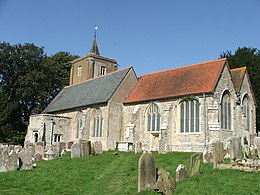
église Saint-Michel
| Pays |  Royaume-Uni Royaume-Uni |
|---|---|
| Région | Angleterre du Sud-Est |
| Comté cérémonial | Kent |
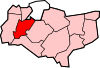
| Comté non métropolitain | Kent (d) |
| District non métropolitain | Tonbridge and Malling |
| Coordonnées | 51° 12′ 36″ N, 0° 22′ 48″ E |
| Statut | Paroisse civile |
|---|
| Indicatif téléphonique | 01622 |
|---|

modifier - modifier le code - modifier Wikidata
East Peckham est une localité du Kent, au Royaume-Uni.
East Peckham est jumelé par la ville de Chereng (France)
Notes et références

Cette section est vide, insuffisamment détaillée ou incomplète. Votre aide est la bienvenue ! Comment faire ?
- Ressource relative à la géographie
 :
: - Open Domesday
v · m Villes et villages de Tonbridge and Malling (district du Kent en Angleterre) | ||
|---|---|---|
|  | |
 Portail de l’Angleterre


