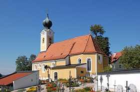
Sankt Gotthard im Mühlkreis

Cet article est une ébauche concernant une localité autrichienne.
Vous pouvez partager vos connaissances en l’améliorant (comment ?) selon les recommandations des projets correspondants.
| Sankt Gotthard im Mühlkreis | ||||
 Héraldique | ||||
 | ||||
| Administration | ||||
|---|---|---|---|---|
| Pays |  Autriche Autriche | |||
| Land |  Haute-Autriche Haute-Autriche | |||
| District (Bezirk) | Urfahr-Umgebung | |||
| Code postal | A- | |||
| Indicatif | 43+ | |||
| Démographie | ||||
| Population | 1 332 hab. ([1]) | |||
| Densité | 111 hab./km2 | |||
| Géographie | ||||
| Coordonnées | 48° 22′ 10″ nord, 14° 07′ 02″ est | |||
| Altitude | 473 m | |||
| Superficie | 1 199 ha = 11,99 km2 | |||
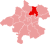
| Localisation | ||||
| Géolocalisation sur la carte : Autriche
Géolocalisation sur la carte : Autriche
Géolocalisation sur la carte : Haute-Autriche
| ||||
modifier  | ||||


Sankt Gotthard im Mühlkreis est une commune autrichienne du district d'Urfahr-Umgebung en Haute-Autriche.
Géographie

Cette section est vide, insuffisamment détaillée ou incomplète. Votre aide est la bienvenue ! Comment faire ?
Histoire
Cette section est vide, insuffisamment détaillée ou incomplète. Votre aide est la bienvenue ! Comment faire ?
v · m Communes dans le district d'Urfahr-Umgebung | ||
|---|---|---|
|  | |
 Portail de l'Autriche

- ↑ « Einwohnerzahl 1.1.2018 nach Gemeinden mit Status, Gebietsstand 1.1.2018 », Statistik Austria (en) (consulté le )


