Boston (district)
Niet-metropolitaans district in Engeland  | |||
|---|---|---|---|
  | |||
| Situering | |||
| Land | Engeland | ||
| County | Lincolnshire | ||
| Regio | East Midlands | ||
| Coördinaten | 52°58'30"NB, 0°1'33"WL | ||
| Algemeen | |||
| Oppervlakte | 364,89[1] km² | ||
| Inwoners (2018[2]) | 69.366 (190 inw./km²) | ||
| ONS-code | E07000136 | ||
| Website | Officiële website | ||
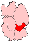
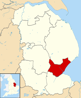
| Detailkaart | |||
 | |||
| |||

Boston (Nederlands, verouderd: Bolstoen) is een Engels district in het shire-graafschap (non-metropolitan county OF county) Lincolnshire en telt 69.000 inwoners. De oppervlakte bedraagt 365 km². Hoofdplaats is Boston.
Van de bevolking is 19,5% ouder dan 65 jaar. De werkloosheid bedraagt 2,8% van de beroepsbevolking (cijfers volkstelling 2001).
Civil parishes in district Boston
Algarkirk, Amber Hill, Benington, Bicker, Butterwick, Fishtoft, Fosdyke, Frampton, Freiston, Holland Fen with Brothertoft, Kirton, Leverton, Old Leake, Sutterton, Swineshead, Wigtoft, Wrangle, Wyberton.
Zie ook
Bronnen, noten en/of referenties
- ↑ Office for National Statistics → Download → SAM_for_Administrative_Areas_(2018).zip → SAM_LAD_DEC_2018_UK.xlsx. Gearchiveerd op 7 april 2023.
- ↑ https://www.ons.gov.uk/file?uri=/peoplepopulationandcommunity/populationandmigration/populationestimates/datasets/populationestimatesforukenglandandwalesscotlandandnorthernireland/mid20182019laboundaries/ukmidyearestimates20182019ladcodes.xls Schatting Office for National Statistics: knop MYE5 → kolom Estimated Population mid-2018]


