Wrexham (county borough)
Unitaire autoriteit in Wales  | |||
|---|---|---|---|
 | |||
| Coördinaten | 53°3'3"NB, 3°0'34"WL | ||
| Algemeen | |||
| Oppervlakte | 503,7739[1] km² | ||
| Inwoners | 136126 (2018)[2] (270 inw./km²) | ||
| Bestuurlijke status | county borough | ||
| Welsh sprekend | 22,9% | ||
| Overig | |||
| ISO 3166-2 | GB-WRX | ||
| ONS-code | W06000006 | ||
| Officiële website | wrexham.gov.uk | ||
| Website | Officiële website | ||
| |||

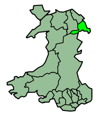
Wrexham (Welsh: Wrecsam) is een unitaire autoriteit in het noordoosten van Wales, gelegen in het ceremoniële behouden graafschap Clwyd en heeft 136.000 inwoners (2018).
De county borough bestaat hoofdzakelijk uit de gelijknamige stad Wrexham en het omringende stedelijke gebied. De huidige county borough ligt verspreid over de historische graafschappen Flintshire en Denbighshire en een belangrijk deel staat historisch bekend als het grensgebied genaamd de Maelor.
Bronnen, noten en/of referenties

Graafschappen: Anglesey · Carmarthenshire · Ceredigion · Denbighshire · Flintshire · Gwynedd · Monmouthshire · Pembrokeshire · Powys
County boroughs: Blaenau Gwent · Bridgend · Caerphilly · Conwy · Merthyr Tydfil · Neath Port Talbot · Rhondda Cynon Taf · Torfaen · Vale of Glamorgan · Wrexham
Steden: Cardiff · Newport · Swansea
Zie ook: behouden graafschappen (preserved counties) en de historische graafschappen


