Wellingborough (distrikt)
| Wellingborough | |||
|---|---|---|---|
| | |||
| Land |  Storbritannia Storbritannia | ||
| Konst. land |  England England | ||
| Region | Øst-Midlands | ||
| Adm. grevskap | Northamptonshire | ||
| Seremonielt grevskap | Northamptonshire | ||
| Status | Distrikt | ||
| Grunnlagt | 1. april 1974 | ||
| Opphørt | 1. april 2021 | ||
| Adm. senter | Wellingborough | ||
| Areal | 163,04 km² | ||
| Befolkning | 75 356 (2011) | ||
| Bef.tetthet | 462,19 innb./km² | ||
| ONS-kode | 34UH | ||
 Wellingborough (distrikt) 52°18′05″N 0°41′40″V | |||
Wellingborough på Commons | |||
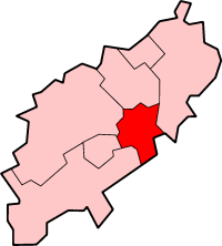
Wellingborough er et administrativt distrikt i Northamptonshire i England. Det har navn etter administrasjonssenteret Wellingborough.
Distriktet ble opprettet 1. april 1974 ved sammenslåing av Wellingborough og Wellingborough landdistrikt. Distriktet dekker et areal på 163,04 km² og hadde 75 356 innbyggere i 2011.[1]
Steder i distriktet
- Bozeat
- Earls Barton, Easton Maudit, Ecton
- Finedon
- Great Doddington, Great Harrowden, Grendon
- Hardwick
- Irchester, Isham
- Little Harrowden
- Mears Ashby
- Orlingbury
- Strixton, Sywell
- Wellingborough, Wilby, Wollaston
Referanser
- ^ «Census 2011: Usual resident population». Nomis. Office for National Statistics. Besøkt 5. juni 2018.
- v
- d
- r
Distrikter i Øst-Midlands

Amber Valley · Ashfield · Bassetlaw · Blaby · Bolsover · Boston · Broxtowe · Charnwood · Chesterfield · Corby · Daventry · Derby · Derbyshire Dales · East Lindsey · East Northamptonshire · Erewash · Gedling · Harborough · High Peak · Hinckley and Bosworth · Kettering · Leicester · Lincoln · Mansfield · Melton · Newark and Sherwood · Northampton · North East Derbyshire · North Kesteven · North West Leicestershire · Nottingham · Oadby and Wigston · Rushcliffe · Rutland · South Derbyshire · South Holland · South Kesteven · South Northamptonshire · Wellingborough · West Lindsey

Administrative grevskap med flere distrikter: Derbyshire - Leicestershire - Lincolnshire - Northamptonshire - Nottinghamshire


