London Borough of Hackney är en kommun (borough) i nordöstra London med cirka 260 000 invånare (2022). Den bildades 1965 när Borough of Hackney, Borough of Shoreditch och Borough of Stoke Newington slogs ihop.
Distrikt
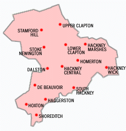
Distrikt som helt eller delvis ligger i Hackney:
Dalston
Hackney
Hackney Marshes
Hackney Wick
Haggerston
Hoxton
Homerton
Lea Bridge
Lower Clapton
Manor House
Stamford Hill
Stoke Newington
Shacklewell
Shoreditch
South Hackney
Upper Clapton
Källor
^”Estimates of the population for the UK, England, Wales, Scotland, and Northern Ireland (Mid-2022)” (på engelska) (xls). Landyta, avrundad till hela km². Office for National Statistics. 26 mars 2024. https://www.ons.gov.uk/peoplepopulationandcommunity/populationandmigration/populationestimates/datasets/populationestimatesforukenglandandwalesscotlandandnorthernireland. Läst 25 juni 2024.
^”Estimates of the population for the UK, England, Wales, Scotland, and Northern Ireland (Mid-2022)” (på engelska) (xls). Office for National Statistics. 26 mars 2024. https://www.ons.gov.uk/peoplepopulationandcommunity/populationandmigration/populationestimates/datasets/populationestimatesforukenglandandwalesscotlandandnorthernireland. Läst 25 juni 2024.
Externa länkar
Wikimedia Commons har media som rör London Borough of Hackney.

 Storbritannien
  England

 Wikimedia Commons har media som rör London Borough of Hackney.Bilder & media


