Albanella
You can help expand this article with text translated from the corresponding article in Italian. (January 2022) Click [show] for important translation instructions.
- Machine translation, like DeepL or Google Translate, is a useful starting point for translations, but translators must revise errors as necessary and confirm that the translation is accurate, rather than simply copy-pasting machine-translated text into the English Wikipedia.
- Do not translate text that appears unreliable or low-quality. If possible, verify the text with references provided in the foreign-language article.
- You must provide copyright attribution in the edit summary accompanying your translation by providing an interlanguage link to the source of your translation. A model attribution edit summary is
Content in this edit is translated from the existing Italian Wikipedia article at [[:it:Albanella (Italia)]]; see its history for attribution. - You may also add the template
{{Translated|it|Albanella (Italia)}}to the talk page. - For more guidance, see Wikipedia:Translation.
Comune in Campania, Italy

Coat of arms
La terra degli ulivi

Albanella within the Province of Salerno
Location of Albanella

40°29′N 15°7′E / 40.483°N 15.117°E / 40.483; 15.117
[1]
(28 February 2017)[2]
84044
21 September (Saint Matthew)
Albanella is a town and comune in the province of Salerno in the Campania region of south-western Italy. It is located 51 kilometers from the city of Salerno.
The town slogan is La terra degli ulivi, which translates to "the land of the olive trees" in English. Olive oil is one of the principal products of the town.
Geography
The town is located halfway between Monti Alburni and the Gulf of Salerno, on a hill commanding the plain of the Sele River. The rest of the municipal area is either flat or, between the Sele and Calore Lucano rivers to the north and Monte Soprano (1,082 m) to the south, hilly.
History
Lying on hills rich with olive trees, Albanella was founded in the 11th century by refugees from Paestum, seeking for a site which would be safe from Saracen raids. The most ancient settlement is in fact on the hill's side which is hidden from the sea.
Several archaeological findings are now in the National Archaeological Museum in Paestum and in the National Archaeological Museum of Naples.
Frazioni
The comune includes the following hamlets (frazioni):
| Frazione and localities | Inhabitants[3] | Altitude (metres) | Distance from main town |
|---|---|---|---|
| Albanella (capital) | 1.585 | 205 m | -------- |
| Matinella | 1.780 | 43 m | 6 km |
| Borgo San Cesareo | 265 | 26 m | 9 km |
| San Nicola | 188 | 55 m | 3 km |
| Tempa delle Guardie | 122 | 151 m | 1.5 km |
| Piano del Carpine | 82 | 100 m | 3 km |
| Bosco | 80 | 100 m | 3 km |
| Vuccolo Cappasanta | 73 | 29 m | 4 km |
| San Cesareo | 55 | 27 m | 9 km |
| Perelle | 53 | 86 m | 2.5 km |
| Bosco Camerine | 46 | 157 m | 3.5 km |
| Cerrina | 39 | 63 m | 3 km |
| Vallecentanni | 36 | 75 m | 5.5 km |
| Santa Croce | 28 | 180 m | 4 km |
| Forestelle | 25 | 85 m | 2 km |
| San Chirico | 22 | 51 m | 5 km |
| Raccoli | 14 | 36 m | 3.5 km |
Matinella
Matinella is the largest frazione in the comune of Albanella, located about 6 km from the center of the township at the intersection of roads from Eboli (via Persano) and Altavilla Silentina which leads to Capaccio-Paestum, and the Provincial Road No. 11 from Ponte Barizzo which leads to Albanella. Because of the low-lying country in recent decades the village has experienced significant population growth that has brought almost a third of the municipal population.

Borgo San Cesareo
In 1950, the government launched a series of legislative measures in Agrarian Reform. These measures, implemented in specific provinces (Campania, Lazio, Puglia, etc. ..) had the goal of expropriating the land of large landowners to local laborers and peasants. This led to the creation of the agricultural village and frazione of Borgo San Cesareo, a small village which is about 9 km from Albanella town.
San Nicola
The frazione of San Nicola is located halfway between Albanella town and the frazione Matinella along the Provincial Road 11. Its development is due to the important road junction that links to Albanella and which leads to Altavilla Silentina and Eboli.
Bosco
Bosco is an ancient frazione which takes its name from the vast forests on the slopes of the hills that once lay to the north-east of the village. After centuries of deforestation for timber and to create land for pasture or cultivation the ancient "Bosco" forest is only a small area today of about one hundred acres, bordering the territory of Castelcivita and Roccadaspide, saved through by the WWF.
Main sights
Church of Santa Sofia
Built in the 16th century.
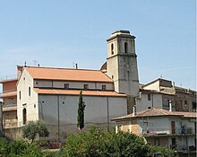
Church of St. Matthew (San Matteo)
Dating back to 1400, this church stands in the heart of the historic center on a small hill where there was previously an old Roman settlement. The church is characterized by two aisles and a bell tower in Romanesque style, and has a great organ.
Chapel of the Congregation of SS. Rosario
It is located in the old town opposite the Church of St. Matthew. It is the newest of the three Catholic churches in Albanella, dating back to the 19th century. The external façade has a majolica panel, realized in Vietri, depicting the Madonna del Rosario between St. Dominic and St. Catherine of Siena.
Church of San Gennaro
Better known as the Church of St. Anne (Chiesa di Sant'Anna) because of the statue of the saint, it is located in the frazione of Matinella.
Church of San Giuseppe Lavoratore
A modern church built in the 20th century located in the frazione of Borgo San Cesareo.
Wind farm

On the hill of San Chirico, a few kilometres west of Albanella town, are ten wind turbines, visible from the Amalfi Coast.
The plant, which was established in February 2004, features ten wind turbines (model V52) of 850 kW each producing more than 20 million kWh per year. The wind farm has been designed and developed by the IWT (Italian Wind Technology) headed the Danish multinational Vestas.
Twin towns

References
External links
Wikimedia Commons has media related to Albanella.
- (in Italian) Albanella official site
- v
- t
- e
- Acerno
- Agropoli
- Albanella
- Alfano
- Altavilla Silentina
- Amalfi
- Angri
- Aquara
- Ascea
- Atena Lucana
- Atrani
- Auletta
- Baronissi
- Battipaglia
- Bellizzi
- Bellosguardo
- Bracigliano
- Buccino
- Buonabitacolo
- Caggiano
- Calvanico
- Camerota
- Campagna
- Campora
- Cannalonga
- Capaccio
- Casal Velino
- Casalbuono
- Casaletto Spartano
- Caselle in Pittari
- Castel San Giorgio
- Castel San Lorenzo
- Castelcivita
- Castellabate
- Castelnuovo Cilento
- Castelnuovo di Conza
- Castiglione del Genovesi
- Cava de' Tirreni
- Celle di Bulgheria
- Centola
- Ceraso
- Cetara
- Cicerale
- Colliano
- Conca dei Marini
- Controne
- Contursi Terme
- Corbara
- Corleto Monforte
- Cuccaro Vetere
- Eboli
- Felitto
- Fisciano
- Furore
- Futani
- Giffoni Sei Casali
- Giffoni Valle Piana
- Gioi
- Giungano
- Ispani
- Laureana Cilento
- Laurino
- Laurito
- Laviano
- Lustra
- Magliano Vetere
- Maiori
- Mercato San Severino
- Minori
- Moio della Civitella
- Montano Antilia
- Monte San Giacomo
- Montecorice
- Montecorvino Pugliano
- Montecorvino Rovella
- Monteforte Cilento
- Montesano sulla Marcellana
- Morigerati
- Nocera Inferiore
- Nocera Superiore
- Novi Velia
- Ogliastro Cilento
- Olevano sul Tusciano
- Oliveto Citra
- Omignano
- Orria
- Ottati
- Padula
- Pagani
- Palomonte
- Pellezzano
- Perdifumo
- Perito
- Pertosa
- Petina
- Piaggine
- Pisciotta
- Polla
- Pollica
- Pontecagnano Faiano
- Positano
- Postiglione
- Praiano
- Prignano Cilento
- Ravello
- Ricigliano
- Roccadaspide
- Roccagloriosa
- Roccapiemonte
- Rofrano
- Romagnano al Monte
- Roscigno
- Rutino
- Sacco
- Sala Consilina
- Salento
- Salerno
- Salvitelle
- San Cipriano Picentino
- San Giovanni a Piro
- San Gregorio Magno
- San Mango Piemonte
- San Marzano sul Sarno
- San Mauro Cilento
- San Mauro la Bruca
- San Pietro al Tanagro
- San Rufo
- San Valentino Torio
- Sant'Angelo a Fasanella
- Sant'Arsenio
- Sant'Egidio del Monte Albino
- Santa Marina
- Santomenna
- Sanza
- Sapri
- Sarno
- Sassano
- Scafati
- Scala
- Serramezzana
- Serre
- Sessa Cilento
- Siano
- Sicignano degli Alburni
- Stella Cilento
- Stio
- Teggiano
- Torchiara
- Torraca
- Torre Orsaia
- Tortorella
- Tramonti
- Trentinara
- Valle dell'Angelo
- Vallo della Lucania
- Valva
- Vibonati
- Vietri sul Mare
Authority control databases | |
|---|---|
| International |
|
| Other |
|


