Drescher Inlet
Inlet of Antarctica
Drescher Inlet, also known as Dreschereisfrontkerbe, is an inlet or iceport in the front Riiser-Larsen Ice Shelf on the coast of Queen Maud Land, Antarctica. Some 25 km long and 3 km wide, it was named after Eberhard Drescher (1944–1983), a marine biologist at Germany's Alfred Wegener Institute for Polar and Marine Research.
Important Bird Area
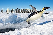
A 368 ha site on fast ice near the inlet has been designated an Important Bird Area (IBA) by BirdLife International because it supports a colony of about 6,600 emperor penguins, the number estimated from 2009 satellite imagery. Weddell seals are also known to breed in the vicinity.[1]
References
- ^ "Drescher Inlet (Dreschereisfrontkerbe)". BirdLife Data Zone. BirdLife International. 2015. Retrieved 2 November 2020.
72°49′57″S 19°13′07″W / 72.83250°S 19.21861°W / -72.83250; -19.21861
- v
- t
- e
Important Bird Areas of Antarctica
- Berkner Island
- Coalseam Cliffs
- Mount Faraway
- Stewart Buttress
- Dawson-Lambton Glacier
- Luitpold Coast
- Stancomb-Wills Glacier
- Amanda Bay
- Bluff Island
- Boyd Island
- Caro Island
- Donskiye Islands
- Filla Island
- Gardner Island
- Hop Island
- Kazak Island
- Lucas Island
- Lugg Island
- Magnetic Island
- Rookery Lake
- Tryne Islands
- Turner Island
- Warriner Island
- Waterhouse Island
- West Ice Shelf
- Zolotov Island
- Arthurson Ridge
- Kartografov Island
- Mount Archer
- Sturge Island
- Adélie Cove
- Blue Glacier to Cape Chocolate
- Cape Adare
- Cape Main
- Cape Roget
- Cape Wadworth
- Cape Washington
- Cotter Cliffs
- Dailey Islands
- Depot Island
- Downshire Cliffs
- Duke of York Island
- Dunlop Island
- Edmonson Point
- Foyn Island
- Gregory Island
- Inexpressible Island
- Mandible Cirque
- Possession Islands
- Seabee Hook
- Brownson Islands
- Edwards Islands
- Hummer Point
- Lindsey Islands
- Maher Island
- Mathewson Point
- Mount Paterson
- Thurston Glacier
- Worley Point
- Ambush Bay
- Apéndice Island
- Armstrong Reef
- Avian Island
- Bates Island
- Brash Island
- Brown Bluff
- Cape Evensen
- Cape Wollaston
- Cierva Point
- Cockburn Island
- Cormorant Island
- Cuverville Island
- D'Urville Monument
- Danger Islands
- Devil Island
- Dion Islands
- Dodman Island
- Dream Island
- Duroch Islands
- Earle Island
- Eden Rocks
- Emperor Island
- Gerlache Island
- Ginger Islands
- Gourdin Island
- Guépratte Island
- Hope Bay
- Joubin Islands
- Lagotellerie Island
- Litchfield Island
- Madder Cliffs
- Midas Island
- Moss Islands
- Murray Island
- Paulet Island
- Pearl Rocks
- Penguin Point
- Petermann Island
- Pursuit Point
- Rosenthal Islands
- Ryder Bay Islands
- Snow Hill Island
- Stonington Island
- Trinity Island
- Tupinier Islands
- Uruguay Island
- Admiralty Bay
- Ardley Island
- Aspland Island
- Baily Head
- Barnard Point
- Byers Peninsula
- Cape Bowles
- Cape Garry
- Cape Hooker
- Cape Lookout
- Cape Melville
- Cape Shirreff
- Cape Wallace
- Chinstrap Cove
- Eadie Island
- East of Nelly Point
- Eastern Litwin Bay
- Escarpada Point
- False Round Point
- Fur Seal Point
- Gibbs Island
- Half Moon Island
- Harmony Point
- Heywood Island
- Jameson Point
- Kellick Island
- Lions Rump
- Milosz Point
- Mount Elder
- North Foreland
- O'Brien Island
- Owen Island
- Penguin Island
- Point Hennequin
- Point Wordie
- Potter Peninsula
- Pottinger Point
- Saddleback Point
- Seal Islands
- Stinker Point
- Sugarloaf Island
- Tartar Island
- Vapour Col
- Walker Point
- Yankee Harbour
- Atriceps Island
- Buchanan Point
- Cape Davidson
- Cape Hansen
- Cape Robertson
- Cape Whitson
- Cheal Point
- Christoffersen Island
- Eillium Island
- Ferguslie Peninsula
- Ferrier Peninsula
- Fraser Point
- Fredriksen Island
- Gibbon Bay
- Gosling Islands
- Graptolite Island
- Grey Island
- Inaccessible Islands
- Larsen Islands
- Matthews Island
- Michelsen Island
- Moe Island
- Moreton Point
- Pirie Peninsula
- Point Martin
- Return Point
- Robertson Islands
- Shingle Cove
- Signy Island
- Skilling Island
- Southern Powell Island
- Watson Peninsula
- Weddell Islands
Portals:
 Birds
Birds Geography
 Earth sciences
 Weather


This Princess Martha Coast location article is a stub. You can help Wikipedia by expanding it. |
- v
- t
- e


