Thurston Glacier
Glacier of Antarctica


Thurston Glacier
class=notpageimage|
Location in Antarctica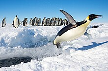
Thurston Glacier is a glacier about 28 km (17 mi) long which drains the south-eastern slopes of Mount Siple on Siple Island. The glacier trends eastward and then east-north-eastward to reach the northern shore of the island. It was mapped by the United States Geological Survey (USGS) from surveys and United States Navy aerial photography, 1959–65.
Discovery and naming
The glacier was named by the Advisory Committee on Antarctic Names (US-ACAN) for Thomas R. Thurston, a United States Antarctic Research Program (USARP) meteorologist at Byrd Station in 1965.[1]
Important Bird Area
A 293 ha site, comprising the marine area and fast ice that forms near the terminus of the glacier, has been designated an Important Bird Area (IBA) by BirdLife International because it supports a breeding colony of about 3,000 emperor penguins, estimated from 2009 satellite imagery.[2]
References
![]() This article incorporates public domain material from "Thurston Glacier". Geographic Names Information System. United States Geological Survey.
This article incorporates public domain material from "Thurston Glacier". Geographic Names Information System. United States Geological Survey. ![]()
73°18′S 125°18′W / 73.300°S 125.300°W / -73.300; -125.300
Portal:
 Geography

- v
- t
- e
- List of glaciers in the Antarctic: A–H
- List of glaciers in the Antarctic: I–Z
- Adélie Land
- Bouvet Island
- Coats Land
- Ellsworth Land
- Enderby Land
- Graham Land
- Heard Island and McDonald Islands
- James Ross Island and Graham Land
- Kaiser Wilhelm II Land
- Kemp Land
- Mac. Robertson Land
- Marie Byrd Land
- Oates Land
- Palmer Archipelago and Graham Land
- Palmer Land
- Princess Elizabeth Land
- Queen Elizabeth Land
- Queen Mary Land
- Queen Maud Land
- Ross Dependency
- South Georgia
- South Shetland Islands
- South Orkney Islands
- Trinity Peninsula and Graham Land
- Victoria Land
- Wilkes Land
 | This Marie Byrd Land location article is a stub. You can help Wikipedia by expanding it. |
- v
- t
- e


