Grade II* listed buildings in Hertsmere
Map all coordinates using OpenStreetMap
Download coordinates as:
- KML
- GPX (all coordinates)
- GPX (primary coordinates)
- GPX (secondary coordinates)
There are over 20,000 Grade II* listed buildings in England. This page is a list of these buildings in the district of Hertsmere in Hertfordshire.
Hertsmere
| Name | Location | Type | Completed [note 1] | Date designated | Grid ref.[note 2] Geo-coordinates | Entry number [note 3] | Image |
|---|---|---|---|---|---|---|---|
| Aldenham House and Stable Block | Elstree, Aldenham, Hertsmere | Country House | c. 1672 | 1 September 1953 | TQ1685196530 51°39′20″N 0°18′44″W / 51.655422°N 0.312217°W / 51.655422; -0.312217 (Aldenham House and Stable Block) | 1346891 |  More images |
| Batlers Green House | Batlers Green, Aldenham, Hertsmere | House | c. 1500 | 1 September 1953 | TQ1557798543 51°40′26″N 0°19′48″W / 51.673777°N 0.32996°W / 51.673777; -0.32996 (Batlers Green House) | 1296473 |  Upload Photo |
| Holly Bush Public House | Elstree, Elstree and Borehamwood, Hertsmere | House | 17th century | 30 April 1974 | TQ1786695461 51°38′44″N 0°17′52″W / 51.645603°N 0.297911°W / 51.645603; -0.297911 (Holly Bush Public House) | 1103589 |  More images |
| The Leys | Elstree and Borehamwood, Hertsmere | House | 1901 | 7 June 1995 | TQ1832694896 51°38′26″N 0°17′29″W / 51.640429°N 0.291457°W / 51.640429; -0.291457 (The Leys) | 1263392 | Upload Photo |
| Church of St Margaret | Ridge, Hertsmere | Parish Church | 14th century | 25 February 1952 | TL2136600462 51°41′23″N 0°14′44″W / 51.689803°N 0.245616°W / 51.689803; -0.245616 (Church of St Margaret) | 1103539 |  More images |
| Salisbury Hall | London Colney, Shenley, Hertsmere | Country House | 1668-79 | 25 February 1952 | TL1953502827 51°42′41″N 0°16′17″W / 51.71145°N 0.271282°W / 51.71145; -0.271282 (Salisbury Hall) | 1346960 | 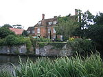 More images |
| St Botolphs | Shenley | House | 1970s | 25 February 1952 | TL1832501859 51°42′11″N 0°17′21″W / 51.703007°N 0.289115°W / 51.703007; -0.289115 (St Botolphs) | 1308251 |  More images |
| Knightsland Farm House | Barnet, South Mimms, Hertsmere | House | c. 1600 | 20 May 1949 | TQ2335998500 51°40′18″N 0°13′03″W / 51.671737°N 0.217491°W / 51.671737; -0.217491 (Knightsland Farm House) | 1346930 |  More images |
| Lodges and arched Gateway to Dyrham Park | Dyrham Park, South Mimms, Hertsmere | Gate Lodge | c1790-1800 | 20 May 1949 | TQ2324298924 51°40′32″N 0°13′09″W / 51.675573°N 0.219033°W / 51.675573; -0.219033 (Lodges and arched Gateway to Dyrham Park) | 1103565 |  More images |
| Church of St James | Bushey, Hertsmere | Parish Church | early/mid 13th century | 14 September 1949 | TQ1303195223 51°38′40″N 0°22′04″W / 51.644456°N 0.367835°W / 51.644456; -0.367835 (Church of St James) | 1103603 |  More images |
| Hilfield Castle | Patchetts Green, Hertsmere | Castle | 1798-99 | 1 June 1984 | TQ1529096295 51°39′13″N 0°20′05″W / 51.653632°N 0.334849°W / 51.653632; -0.334849 (Hilfield Castle) | 1103569 |  More images |
| Lululaund | Bushey, Hertsmere | House | 1886-1894 | 21 June 1978 | TQ1364695195 51°38′39″N 0°21′32″W / 51.64408°N 0.35896°W / 51.64408; -0.35896 (Lululaund) | 1103577 |  More images |
| Wrotham Park and Stable Block | Barnet, Hertsmere | Country House | 1754 | 20 May 1949 | TQ2479099155 51°40′38″N 0°11′48″W / 51.677308°N 0.196574°W / 51.677308; -0.196574 (Wrotham Park and Stable Block) | 1174715 | 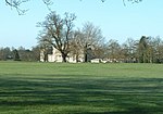 More images |
Notes
- ^ The date given is the date used by Historic England as significant for the initial building or that of an important part in the structure's description.
- ^ Sometimes known as OSGB36, the grid reference is based on the British national grid reference system used by the Ordnance Survey.
- ^ The "List Entry Number" is a unique number assigned to each listed building and scheduled monument by Historic England.
External links
- v
- t
- e
Listed buildings in Hertfordshire
| |||||||||||||||||||||
Grade II | |||||||||||||||||||||
|---|---|---|---|---|---|---|---|---|---|---|---|---|---|---|---|---|---|---|---|---|---|
| |||||||||||||||||||||


