Grade II* listed buildings in Stevenage
Map all coordinates using OpenStreetMap
Download coordinates as:
- KML
- GPX (all coordinates)
- GPX (primary coordinates)
- GPX (secondary coordinates)
There are over 20,000 Grade II* listed buildings in England. This page is a list of these buildings in the borough of Stevenage in Hertfordshire.
List
| Name | Location | Type | Completed [note 1] | Date designated | Grid ref.[note 2] Geo-coordinates | Entry number [note 3] | Image |
|---|---|---|---|---|---|---|---|
| The Grange, 5 High Street | High Street, Stevenage | Local Government Office, formerly a Georgian coaching inn[1] | c.1700 or earlier | 18 February 1948 | TL2328825491 51°54′52″N 0°12′32″W / 51.914311°N 0.208933°W / 51.914311; -0.208933 (The Grange, 5 High Street) | 1348064 |  More images |
| 94–98 High Street | High Street, Stevenage | Hall House | 16th century or earlier | 30 September 1976 | TL2337625044 51°54′37″N 0°12′28″W / 51.910275°N 0.207814°W / 51.910275; -0.207814 (94–98 High Street) | 1101179 |  |
| 131 High Street | High Street, Stevenage | Timber Framed House | c1500 or earlier | 18 February 1948 | TL2349724922 51°54′33″N 0°12′22″W / 51.909152°N 0.2061°W / 51.909152; -0.2061 (131 High Street) | 1176497 |  More images |
| 156, High Street | High Street, Stevenage | Timber Framed House | Early 16th century | 10 April 1975 | TL2345824745 51°54′27″N 0°12′24″W / 51.90757°N 0.20673°W / 51.90757; -0.20673 (156, High Street) | 1101140 |  More images |
| 2, Letchmore Road | Letchmore Road Stevenage | Timber Framed House | Late 15th century or early 16th century | 18 February 1948 | TL2353624849 51°54′31″N 0°12′20″W / 51.908487°N 0.205559°W / 51.908487; -0.205559 (2, Letchmore Road) | 1348095 |  More images |
| The Old Bury | Rectory Lane, Stevenage | House | Late 16th century | 18 February 1948 | TL2400826243 51°55′15″N 0°11′54″W / 51.920909°N 0.1982°W / 51.920909; -0.1982 (The Old Bury) | 1348098 |  |
| Chells Manor | Chells, Stevenage | House | Late 14th century or early 15th century | 24 November 1966 | TL2667025295 51°54′42″N 0°09′35″W / 51.911792°N 0.159861°W / 51.911792; -0.159861 (Chells Manor) | 1101434 |  |
| Church of Saint Mary | Shephall Green, Stevenage | Church | C14-Early 15th century | 18 February 1948 | TL2567022959 51°53′28″N 0°10′31″W / 51.891026°N 0.175242°W / 51.891026; -0.175242 (Church of Saint Mary) | 1101152 | 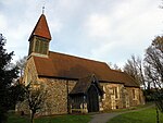 More images |
| The Roebuck Hotel | Hertford Road, Stevenage | House | 16th century | 18 February 1948 | TL2464222094 51°53′01″N 0°11′26″W / 51.883483°N 0.190485°W / 51.883483; -0.190485 (The Roebuck Hotel) | 1308083 |  More images |
| The Dairy, the Old Farmhouse and the Tudor House at Stebbing Farm | Fishers Green, Stevenage | Farmhouse | Late 15th century | 30 September 1976 | TL2232126215 51°55′16″N 0°13′22″W / 51.92103°N 0.222728°W / 51.92103; -0.222728 (The Dairy, the Old Farmhouse and the Tudor House at Stebbing Farm) | 1175952 |  |
Notes
- ^ The date given is the date used by Historic England as significant for the initial building or that of an important part in the structure's description.
- ^ Sometimes known as OSGB36, the grid reference is based on the British national grid reference system used by the Ordnance Survey.
- ^ The "List Entry Number" is a unique number assigned to each listed building and scheduled monument by Historic England.
External links
 Media related to Grade II* listed buildings in Stevenage at Wikimedia Commons
- Stevenage Borough Council list of Listed Buildings
- Listed Buildings in Stevenage at British Listed Buildings
- v
- t
- e
Listed buildings in Hertfordshire
| |||||||||||||||||||||
Grade II | |||||||||||||||||||||
|---|---|---|---|---|---|---|---|---|---|---|---|---|---|---|---|---|---|---|---|---|---|
| |||||||||||||||||||||
- ^ The Grange


